interkriti®
YOUR GATEWAY TO CRETE
HOME
CRETE FACTS
NAVIGATE
EXPLORE

Agia Galini
Triopetra
Kissamos
Chryssi Isl.
Agia Marina
Balos
Gavdos isl.
Georgioupolis
SAMARIA
IDA Mtn
Palaiochora
Agia Roumeli
Sfakaki
Bali
Kalamaki
Matala
Lassithi
Plateau Lendas
Tsoutsouros
Vianos
Myrtos
Sfakia
Plakias
Ierapetra
Makrygialos
ZAKROS
Vai
Sitia
Agios Nikolaos
Elounda
MALIA
Hersonissos
Gouves
Chania
Rethymnon
Heraklion
GORTYN
FESTOS
KNOSSOS
|
|
Crete
List Grid Map
Found
86
- Showing :
61 - 80
 North West Crete at 23.5km (NW) Hania (or Chania GR: Χανιά) is the capital of the Prefecture of the same name and the second biggest town in Crete, with a population of 60.000 inhabitants. It lies (Coordinates 35°31' N 24°1' E ) along the North coast of the island, about 55 km west of Rethymnon and 140 km west of Iraklion (Heraklion). Hania's old town (although it was heavily bombed by Germans in World War II) is considered as Crete's most beautiful urban district, especially the Venetian harbour with its 16th century lighthouse and the Mosque of the Janissaries ("Giali Tzamissi", built 17th century). Many of the old buildings have been restored as hotels, restaurants, shops and bars, making the old town a lively and colourful place, especially during the tourist period.
 Hania old town at 23.5km (NW) An institution of culture, that aims in the creation of necessary "space", where the various sectors of Art, Science and Literature can coexist, each seeking the contribution of the other, thus becoming feasible the materialization of visions that each one of these means of expression of the Human spirit, to be able offer to the community. Address: 98-102, Chalidon Street, 73 131 Chania, Crete, Greece Phone number: +30 28210 92294 / +30 28210 36190 E-Mail: info@pinakothiki-chania.gr Links: Dimodiki Pinakothiki Hanion  Hania at 23.6km (NW) The museum is housed in the katholikon of the Venetian monastery of St. Francis. During the period of the Turkish occupation it was the Muslim mosque of Yussuf Pasha, while in modern times it was used as a cinema or a storehouse for military equipment. Since 1963 it has been functioning as the Archaeological Museum of the city. Apart from the permanent exhibition, the museum houses temporary exhibitions in the frame of certain local events 25 Chalidon Str., tel. +30821 90334 It contains impressive finds from the excavations of the ancient city of Kydonia, from Idramia, Aptera, Polyrinia, Kissamos, Elyros, Irtakina, Syia, Lissos, Chania, Axos, and Lappa.  Sfakia, Hania, Crete at 23.6km (S) At the exit of the ravine of Imbros, near the south coast of Sfakia. It is located at an altitude of 200 m, 68 km from the city of Hania and 4,5 km from Hora Sfakion. The area is covered with olive trees and the view to the Libyan sea and the island of Gavdos in the horizon...
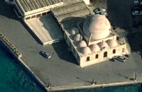 Venetian port, Chania at 23.7km (NW) The temple Kioutsouk (small) Hassan or Giali Tzamisi (seaside mosque), as it was commonly called, a brilliant sample of Islamic art of the Renaissance was a work of an Armenian architect, who had constructed another similar mosque in 'Spaniako', a village in the county of 'Selino'. The mosque, in the yard of which there were palm trees and graves of pashas and janissaries, stopped operating in 1923 and today it is restored without the small and picturesque minaret demolished in 1920.
 Chania at 23.7km (W) Thérisso (GR: Θέρισο) is a small village, built on the foot of the White mountains, at 580 m a.s.l, 20km south of the city of Hania. It has 156 inhabitants and it is famous for its physical beauty, its diary-farming and its glorious past. You can reach Therisso from Perivolia passing through the Canyon (good asphalt road), or from Drakona, crossing the 7km dirt road through the forest. From here starts the trekking path which leads to the highest peak of the White mountains, Pahnes (2452m) Due to its location Therisso played a significant role at the history of the island especially during the 19th Century. A mill's stone located at the entrance of the village reminds the death of a young woman (grinded alive), when she denied to surrender to Mustafa Pasha. Here were born the great Cretan revolutionaries (Hainis), Vassilis, Giannis and Stefanos Halis. Vassilis Halis, became a hainis very young, and participated to the most great battles against the Turks in Crete and Peloponnissos. He was lt General when he died at Nafplion (Peloponnissos) in 1846. But Therisso is mostly known for its relation with the Venizelos movement in March 1905. Venizelos, who dissented with prince George' policy and declared the Union of Crete with Greece, had his headquarters at Therisso. The house of Venizelos is today a museum. The visitor to Therisso will admire the natural beauty, learn a lot of the history of the place listening to various stories and looking at the historical monuments, and taste the local specialties at the lovely taverns of the village. 2,5 km north of Therisso, at the left bank of Kladissos river, there is a cave where signs of neolithic and Minoan habitation were discovered. It is believed that it was a worship place. 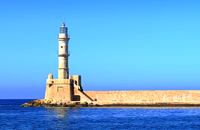 Hania harbour at 23.9km (NW) Chania lighthouse, the jewel of the city, is one of the oldest light houses, not only in Greece and the Mediterranean, but also in the world. The lighthouse (Faros GR: Φάρος) is a major attraction in the old port of Chania especially at night when it's lit up. The tower is 21m high and is built on a stone base, located at the end of the old harbour's pier opposite to the fortress of "Firkas". Visitors are not allowed to enter the tower. Chania lighthouse was first constructed by the Venetians around 1595 - 1601, and it took its final form, in the shape of a minaret, during the Egyptian Period (1831 - 1841) in around 1839. After the latest restoration, completed in 2006, it was given the formation of the Venetian period. The minaret look is still evident however. 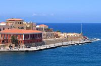 Hania harbour at 23.9km (NW) The fortress on the northwest side of the port was constructed to protect the entrance of the port and maintains its Turkish name "Firká" (Firka=barracks). A chain from "Firka" to the lighthouse blocked the entrance to the port in case of intrusion. The fortress was the headquarters of the Army Commander of the city. 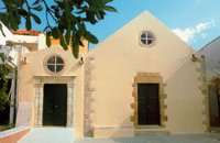 Hania, old town at 23.9km (NW) The Franciscan monastery of San Salvatore, that houses the Byzantine and Post-Byzantine Collection of Chania, was built on the west side of the fortress of Chania, in three phases from the 15th century until the late Venetian period (middle of 17th century). The extensive restoration of the church made it possible to identify more clearly the various building phases of the monument, unify the space, and display its austere, uncluttered architectural features to good effect. The original church, which probably dates from the 15th century, was the small domed section on the east side.  Hania, Venetian port at 23.9km (NW) A two storey house, located at the old port of Hania, with a total area of 840 m2. The exhibition includes about 2,500 exhibits, such as models of ships, different kinds of naval instruments and devices, paintings, heirlooms, gleanings from the sea bottom, shells, photographs etc., which are divided in 13 units, covering chronologically all the periods. 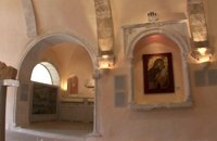 Hania, old town at 24km (NW) The wealth of archaeological material yielded by excavations conducted over many years by the 13th Ephorate of Byzantine Antiquities in the county of Chania, and also by retrieval of material and donations, forms a Collection that records, with great clarity, the history of the westernmost county in Crete from Early Christian times to the period of Turkish rule. Representative examples of this Collection are displayed in the church of San Salvatore.  Rethymno south at 24.1km (S) Two small villages, Epano & Kato (Upper & Lower) Rodakino halfway from Plakias to Frangokastelo, overlooking the bay of Korakas. Rodakino is 42 kms from Rethimnon, 27 kms from Hora Sfakion and 13 kms from Fragokastello. Rodakino is surrounded by small beaches some of them accessible only by foot, were visitors can isolate themselves from any trace of civilization. There are some small hotels and rooms to rent available and a couple of tavernas. The road to Rodakino is asphalt paved and there is a bus service to Rodakino from Rethimnon twice a day. In the village the visitor can find a taxi station, and a gasoline station. A doctor is available for medical emergencies on the village of Plakias approximately 15 kms from Rodakino. Rodakino played its own part during the eons, in the fighting of the Cretans against all the invaders. The village was totally destroyed during the Venetian occupation, with only one resident escaping to Peloponnese in Greece . Years after the destruction he returned to the site of the village, and he rebuilt it. In Kourkoylo one of the quarters of the village the first rising of the flag of the revolution against the Turks was raised on May 24th 1821. During the second World War the kidnapped German general Craipe was sent away from the bay of Korakas to the Middle East. Image Library
 Frangokastello at 24.7km (S) Vatalos is the long beach to the west of the main beach of Frangokastello. It is a stretch of fine sand interrupted by pebbles and rocks that create small coves. There are no umbrellas and sun beds available for rent and the only shadow can be found under the little tamarisks. It is by far less crowded than the main beach. It is frequented mostly by the guests of the hotels that stand above the beach as it is peaceful, and, quite safe for the kids.
Image Library
 Sfakia at 25.2km (SW) Sfakia are centred around the White Mountains mountain range, Madares, as they are called in Crete with 110 peaks and the most and biggest gorges. Sfakia remain the most wild and unspoiled landscape in all Crete. Hora Sfakion, the seaside capital of the county, is a coastal village located on the Southwestern coast of Crete, 70 km from the city of Hania and 150 km from Iraklion. In its picturesque, enclosed harbor, the small boats from Agia Roumeli dock in the summer, bringing the hikers from the Samaria Gorge. Visitors can enjoy the quiet and calm of the village , on the seaside cafes and tavernas...
 Sfakia, South Hania at 25.4km (S) On the south coast of Crete, on a magnificent white sandy beach, stands one of the most beautiful Venetian fortresses, Fragokastello, built in 1371. It is located approximately 170 km from Iraklion, 70 km from Rethimnon, and 70 Km from Hania. Today, Fragokastello is a small, but developing, community, with nice beaches covered in sand dunes, and limited, but increasing, tourist facilities.The Villages Patsianos and Kalikratis, the castle, the history of the place and the fenomenon of Drossoulites...
 Rodakino, South Rethymno at 25.6km (S) At the end of the canyon that traverses the area of Rodakino lies the beach of Korakas at the bay of the same name. It is a nice, wide and 400m long beach, with clear waters and small grayish sand and pebbles. There are a few accommodation options in family run apartment complexes and a few taverns on the beach front. Umbrellas and sun beds are also available at the eastern part. The headland to the east separate Korakas Beach from another lovely beach named "Klimata". At the east side of that headland there is a small fishing harbour and along its coast there are sharp rocks in the shape of a crow's beak (Kórakas GR: Κόρακας, means crow) thus giving the name to the bay. Image Library
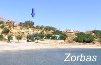 Lakkoi Skalotis, Frangokastelo at 25.7km (S) "Zorbas Rent Rooms and Taverna" run by the family of George GliniadakisThere are five double rooms with private bathroom - hot water 24hrs/day, air conditioning, refrigerator and large verandas with nice view to the sea. The beach is only 80 meters away.The tavern serves breakfast and meals from the morning till late in the night. The traditional Cretan specialities are all made with extra virgin organic olive oil and other products from the owner's farm.
 Cretan hero born in Anopolis, Sfakia at 25.8km (SW) Daskalogiannis (GR: Δασκαλογιάννης) - born in Anopolis, Sfakia - started planning a revolutionary liberation movement in Crete in 1769 and completed the preparations for the revolution in Sfakia in the spring of 1770. In 1770, the revolution that had already broken out in other parts of Greece broke out in Crete too. Daskalogiannis, revolt was the first step towards freedom from the Turkish occupation in Crete and kept people, hopes from freedom alive. The international airport of Chania is named after this hero.
 Sfakia, South Hania at 25.8km (SW) Anopolis is a small village, built on a small but fertile plateau, 12 km west from Sfakia at 600 m above sea level. There are still traces of the ruins of the ancient city that prospered around the 3rd century BC, who's port was Phoenix (Loutro). Ancient Anopolis was one of the thirty city - states that signed the peace decree with Eumenes B’ in 183 BC. and thus was able to mint its own coins. During both the Venetian and the Turkish occupations, Anopolis was a center for revolutionary activities. It is the birth place of the freedom fighter Ioannis Daskalogiannis who's statue stands at the center of the village.There are three more small settlements, Limnia, Vigle and Pavliana on the same plateau. The mountainous landscape is of outstanding wild beauty. In the village there are rooms for rent and a tavern.The village is worth visiting not only for its natural beauty but also for the opportunity to explore the White Mountains. One of the best hikes is to descent to the shore through the ravine of Aradena, a five hour walk through an imposing ravine that ends up to the wonderful beach of Marmara.  Sfakia, South Hania at 27.8km (SW) Loutro is a small village halfway from Agia Roumeli, where the Samarian gorge ends, to Hora Sfakion, accessible only by boat. The majestic scenery, the calm, the crystal clear water and the hospitality of the local people gave Loutro numerous friends and ardent visitors. No cars, no bikes... nothing to spoil the peace of this historical place. Some small hotels, apartments and rooms as well as a few lovely taverns offer their guests a friendly atmosphere that makes Loutro an ideal place for vacation and relax.
|
||
|
| ||


)
C
O
N
T
E
N
T
S
O
N
T
E
N
T
S