interkriti®
YOUR GATEWAY TO CRETE
HOME
CRETE FACTS
NAVIGATE
EXPLORE

Agia Galini
Triopetra
Kissamos
Chryssi Isl.
Agia Marina
Balos
Gavdos isl.
Georgioupolis
SAMARIA
IDA Mtn
Palaiochora
Agia Roumeli
Sfakaki
Bali
Kalamaki
Matala
Lassithi
Plateau Lendas
Tsoutsouros
Vianos
Myrtos
Sfakia
Plakias
Ierapetra
Makrygialos
ZAKROS
Vai
Sitia
Agios Nikolaos
Elounda
MALIA
Hersonissos
Gouves
Chania
Rethymnon
Heraklion
GORTYN
FESTOS
KNOSSOS
|
|
Crete
: Culture
List Grid Map
Found
44
- Showing :
1 - 20
 Agios Vassilios, Rethymnon south at 4.1km (SE) It stands 37 km south of Rethimnon, in an imposing landscape which is mentioned at the mid-19th century diary of Th. Spratt (admiral of the British Royal Navy), as "one of the happiest places to withdraw from trials and responsibilities of life".There are lots of legends concerning the foundation of the monastery, which is believed that started during the Venetian occupation of the island. A number of its monks activities made the monastery one of the richest of western Crete and due to its isolated position it played important role in Cretan revolts against the occupying forces. A substantial number of icons and other items is kept in the Museum of the Monastery of Preveli amongst them the miracle - working Eulogistic Cross of Efraim Prevelis.
Image Library
 Armenoi, Rethymnon at 16.5km (N) The site was first discovered by a teacher who noticed that two pupils were playing football using a minoan vase as a ball!. He mentioned the fact to the authorities and the excavations that followed unearthed about 300 tombs of the Late Minoan III period (1450-1100 BC). As the tombs had not been yet looted, the archaeologists found significant treasures like vases, weapons, statuettes, jewels etc. It is obvious that such a big cemetery should belong to a big city which, despite the extended investigations of the archaeologists, has not been discovered yet. Image Library
 Gonia, Rethymno at 19.5km (N) The Municipality of Nikiforos Fokas is located in the north of Rethymnon Prefecture. The area is known for its outstanding natural beauty and its historical tradition and architecture. All of the municipality's settlements are steeped in history and contain fine examples of architecture, featuring stone buildings with vaulted entrances (known as "diavatika") and magnificent thresholds. The municipality's jurisdiction extends over the fourteen former community wards of Agios Konstantinos, Ano Valsamonero, Atsipopoulo, Gerani, Gonia (Athanatos), Zouridi, Kalonyktis, Kato Valsamonero, Malaki, Mountros, Prines, Roustika, Saitoures and Frantzeskiana Metochia, which comprise a total of 21 villages.  Rethymnon city at 22km (N) In winter the town of Rethymno lives in the rhythm of Carnival. Here, the grandest carnival on the island of Crete is organised. Apart from the great parade on Shrove Sunday, a large number of activities complete the framework of the Carnival festivities. The locals devotedly and cheerfully prepare for this season with creativity, they sacrifice their spare time and become young again while rejoicing and celebrating parties almost on a daily basis. More than 4,000 people have worked feverishly for months in order to present their masks and carriages on the great Carnival parade…The following day, on Shrove Monday people from the countryside play a leading part in the festivities. Unique traditions are revived in the villages and everybody is invited to participate in games, street performances and satires as for example “the kidnapping of the bride”, the “Cadi”, the “smudging of people”. These performances in combination with good wine and the music of the lyre are a successful formula for a unique experience. Links: www.carnivalrethymno.com  Rethymnon Old Town at 22.1km (N) The Mosque took its name from the Turkish commander of the marine operations to conquer Rethymno, in 1646. During the Venetian Period, the Mosque became a monastery dedicated to St. Barbara. West from the central building, there is the deserted minaret of the mosque. The fountain of the Mosque is attached to the roofed entrance of the Mosque's garden, where believers washed before entering the Mosque and provided the area with fresh spring water. Image Library
 Rethymnon Old Town at 22.2km (N) It is housed in the church of Agios Frangiskos in the center of the old town. It exhibits objects from the Neolithic to the Roman period, found at the prefecture of Rethymno (mainly Eleftherna, Monastiraki and Armeni). Clay figurines, funerary coffers, grave offerings, statues, grave steles, red-figure vases, bronze vessels, jewellery and glass vases, are some of the objects on display. St. Francis Church - 4 Agiou Fragiskou str., Telephone: +30 28310 27506 Email: efareth@culture.gr Open Winter: 08:00 - 15:00 November 1 - March 31 Summer: 10:00 - 18:00 April 1 - October 31, except Tuesday. 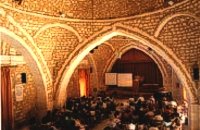 Rethymnon old town at 22.2km (N) During Venetian occupation the mosque Neratzes, which today is used as a conservatory, was the Augustinian church of the Holy Virgin. In 1657 the Turks transformed it into the mosque 'Gazi Housein' or 'Neratze', and in 1890 they added a large minaret with two galleries, which was built from the famous stones from the village of Alfa. The chapel of the Holy Virgin, situated at its west side and dedicated to the Body of Christ, was also transformed into a seminary. Outstanding elements of this building are the doorframe and the three domes.
Image Library
 Rethymnon old town at 22.2km (N) The Historical and Folklore Museum of Rethymno is located next to the Neratze Mosque. It is an institution of public benefit, founded in 1973 by the President of the Historical and Folklore Institution, Christoforos Stavroulakis, and Fali Vogiatzaki. The museum is housed in a restored Venetian building with an interior courtyard. The building is a wonderful piece of urban residence of the last phase of the Venetian occupation of Crete, built in the renaissance style by traditional craftsmen. Image Library
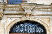 Rethymnon Old Town at 22.2km (N) The church of Saint Francis is one of the most important monuments of Rethymno. It was the main temple of the Monastery of the Franciscan Order. The architecture of the building - a single aisle Basilica type with wooden roof - and its ornaments are very interesting. Next to the east side of the temple two deserted chapels are preserved. Its Corinthian style main doorway is impressive, with capitals of composite order. During recent excavations around the church valuable archeological findings have been discovered, including two tombs of Venetian nobles. During the Turkish occupation the temple was turned into an "Imaret" (a shelter for the poor). It was also used as a cultural center until 1996. It was recently renovated to accommodate the Byzantine and Post-Byzantine Collection of the Prefecture of Rethymno. 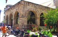 Rethymnon Old Town at 22.3km (N) Loggia has been built during the 16th century and was designed by the famous architect Michel Sanmicheli. Loggia was an eminent building of the city centre and has been a meeting point for the nobles to discuss political and economical issues. The building is very well preserved; it is square and has arches on its three sides (besides its west side). The consoles of its eaves are spectacular. During the Turkish occupation the loggia became a mosque and a minaret was constructed, which was later demolished in 1930. The past 40 decades the building of Loggia hosted the archaeological museum of the city, which has now moved to a building next to Fortezza. Today loggia hosts a market of archaeological art copies.
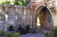 Rethymnon Old Town at 22.3km (N) A. Rimondi, the Rector of the city, built the famous Rimondi Fountain, which is situated at present day Platanos Square, formerly the centre of Venetian city life, in 1626. The water runs from three spouts in the shape of a lion's head into three sinks. Three small, fluted columns, ornamented with Corinthian capitals are "standing" on the sinks. Above the capitals an entablature can be observed, the middle part of which displays four projections in the shape of the leaves of the acanthus exactly above the columns. Furthermore in this section the words LIBERALITATIS and FONTES are inscribed.
Image Library
 Rethymnon Old Town at 22.4km (N) The Contemporary Art Museum of Crete was founded in 1992 as Municipal Gallery ‘L. Kanakakis'. It is housed in a Venetian building at the old city of Rethymno, below the Fortezza fortress and the Archaeological Museum. It houses a permanent exhibition of the work of Lefteris Kanakakis (oil paintings, sketches and aquarelles), thus representing all the stages of his achievements, as well as works of contemporary Greek artists, which cover a broad spectrum of modern Greek art as it has been accomplished from 1950 until today. Address: 5, Heimaras Str. 741 00 Rethymno Tel: +30 28310 52530 Website :www.rca.gr  Rethymnon city at 22.4km (N) The Institute for Mediterranean Studies (IMS) based in Rethymno, Crete, was founded in 1985 and belongs to the research units of the Foundation for Research and Technology, Hellas (FORTH). The IMS is the only FORTH centre which deals with the human and social sciences. The purpose of IMS is to support and invigorate research in the field of the human and social sciences, as well as to promote the application of advanced technologies in the field. The IMS possesses a fully equipped Laboratory of Geophysical-Satellite Remote Sensing (GIS) & Archaeo-environment, specialized in archaeological research. The Library of the Institute is focused on Turkish Studies and Art History. In the Library archival material, as well as collections of Greek and foreign newspapers in digital form and microfilms are kept. The objective of the IMS's research programs is to study the geographical space, the history and culture of Greece and the other Mediterranean countries in various historical periods, from prehistory to modern times. In order to achieve these objectives, the research projects of the Institute are organized along the following axes: Turkish Studies History Studies Art History History of the Theatre - Ethnomusicology The Laboratory of Geophysical-Satellite Remote Sensing & Archaeo-environment Its activities concern the field of geophysical research, the satellite remote sensing, the Geo-information technologies and the archaeo-environment, with emphasis on the Mediterranean region. The Laboratory is a member of international organisations such as EPOCH, EARSel. and AGILE and participates in a number of joint research and technology programs in Greece and abroad (e-Content, INTERREG, ARCHIMED, ETPA, PEWNED, EPEAEK, INSTAP, LIFE, Region of Crete). The research programs of the Institute are carried out by its permanent researchers and collaborating faculty members. In the frame of these research programs are prepared PhD Thesis and other diplomas which are submitted to the higher educational institutions with which IMS collaborates and, particularly, to the University of Crete, the Technical University of Crete and the Technological Educational Institute of Crete. The IMS supports education at post-graduate and post-doctoral level with a considerable number of annual scholarships, thus contributing to attract a steady flow of young researchers and to promote research in the field of humanities at the periphery. The IMS maintains close academic links with various international research foundations (Cyprus, Turkey, Bulgaria, Italy, France, Spain, England, Belgium, Tunesia, Egypt, China, USA, a.o.). The IMS is administered by a director and a five member academic council (A.C.). It is housed in wholly-owned premises comprising of two listed buildings in the old town of Rethymno. The core of one edifice dates back to the Venetian period (13th - 17th century). Links: www.ims.forth.gr/  Rethymnon town at 22.5km (N) The Fortezza castle, at the top of a low hill named "Palaiokastro" dominates the town. It was built in 1590 to protect the city from the pirates raids and the Turks. The name "Palaiokastro which means 'The old Castle' was in use even by the Venetians which demonstrates the existance of an even older castle at this place. - Probably the acropolis of the ancient town of Rithymna. The interior of Fortezza accommodated the following basic buildings: the storeroom of the artillery, where canons and weapons were kept, the residence of the Councilors, where one of the city's two Venetian councilors lived, the residence of the Rector, which represented a luxurious, magnificent building in the central square of the fortress. Today parts of those buildings, as well as of some others built later, can be seen. The view from up there is magnificent, especially at night. The municipal theatre "Erofili" stands also at Fortezza's premises. It is an outdoor theatre that hosts almost all the performances during the Renaissance Festival. Image Library
 Amari, Rethymnon at 22.6km (NE) Sivritos (GR: Σίβρυτος) was an important and autonomous city of the ancient Crete. The city was built in the location that today is the village of Thronos. It was located on a hill dominating the valley of Amari. The name Sivritos is derived from the words si, that in the ancient eastern languages meant water, and the word vriti, that is of prehistoric origin and meant sweet. Therefore, Sivritos in the Minoan period meant sweet water. The derivation is also verified by the fact that near the hill where the city was located there are numerous sweet water springs. Monastiraki (The archaeological site) Amari at 24km (E) Monastiraki lies in the valley of Amari, on the natural route leading from northern Crete to the Messara plain. Excavations have brought to light a centre of the Old Palace period (1950-1700 B.C.). which was destroyed by fire following an earthquake. The large number of storerooms and the existence of two archive rooms with many clay sealings indicate a palatial character for the site. Other finds on the top of a neighbouring hill suggest there must have been a religious centre in the area, as well. Image Library
 Rethymno at 24.5km (NE) The Monastery of Arkádi (GR:Αρκάδι) built during the last Venetian period, it consists of a large set of fortress-like buildings. The main building included the cells, the warehouses where the agricultural products were treated and stored, the stables. In a word, it was a well-equipped little fortress where people could find refuge in times of trouble. There is an impressive church, with two naves dedicated to Saint Constantine and Saint Helen, and to Our Lord. Due to the holocaust it suffered in 1866, Arkadi has become the island's most famous monastery.
Image Library
 Messara Bay, Iraklion at 25km (SE) Two small dry and uninhabited islets off the bay of Messara, ~7.5 naut. miles to the west of Matala. Due to their close proximity to one another the two islands appear as one from a distance. They are also called "elephantaki" as from north they look like a baby elephant that is lying down. In mythology it is believed that the goddess Lito gave birth to the god Apollon and the goddess Artemis on these islands. In antiquity they were called Dionissioi after the god Dionissos. During the summertime there are small cruising boats that bring tourists here from Agia Galini and Kokkinos Pyrgos. There is only a small beach with fine pebble and rich seabed at the south side of the easternmost islet.  Sfakia at 25.4km (W) Sfakia are centred around the White Mountains mountain range, Madares, as they are called in Crete with 110 peaks and the most and biggest gorges. Sfakia remain the most wild and unspoiled landscape in all Crete. Hora Sfakion, the seaside capital of the county, is a coastal village located on the Southwestern coast of Crete, 70 km from the city of Hania and 150 km from Iraklion. In its picturesque, enclosed harbor, the small boats from Agia Roumeli dock in the summer, bringing the hikers from the Samaria Gorge. Visitors can enjoy the quiet and calm of the village , on the seaside cafes and tavernas...
 Amari, Rethymnon at 29.1km (E) The village of Apodoulou is located 55 km from Rethimno at an altitude of 450m. Remains of an extensive centre of the Old Palace period (1950-1700 B.C.) have been uncovered.at the site called Gournes, near the village of Apodoulou, at the west foot of Psiloreitis. The site dominates the Amari valley and controls the main route to the Messara plain. Excavations have brought to light three building complexes while tholos tombs of the Postpalatial period (1380-1200 B.C.) have also been located in the adjacent area. The first excavations on the site were carried out by S. Marinatos in the 1930's. During World War II it was excavated by the German Archaeological Institute, under the direction of E. Kirsten. Since 1985, systematic excavations have been carried out by the Greek Ministry of Culture in collaboration with the University of Naples. The most important monuments on the site are: Building A. It lies on the east side of the hill, to the south of the massive retaining wall. It had two storeys, as is indicated by the two preserved steps of a staircase. Decades of pithoi and other vases found on the ground floor suggest that it was used for storage. The house was destroyed by fire which followed an earthquake. Building B, located to the north of the retaining wall. It is a complex of rooms which originally communicated with Building A. Building C. It lies to the east of house A and belongs to a later phase of the settlement. Tholos tomb at Sopatakia. Tholos tomb with dromos, lying to the east of the road that leads from Apodoulou to Nithavris. The dromos is 7 m. long and the chamber has a diameter of 3.10 m. Three larnakes were found inside the burial chamber. Dated to 1380-1200 B.C. Source: The Hellenic Ministry of Culture |
||
|
| ||


C
O
N
T
E
N
T
S
O
N
T
E
N
T
S