interkriti®
YOUR GATEWAY TO CRETE
HOME
CRETE FACTS
NAVIGATE
EXPLORE

Agia Galini
Triopetra
Kissamos
Chryssi Isl.
Agia Marina
Balos
Gavdos isl.
Georgioupolis
SAMARIA
IDA Mtn
Palaiochora
Agia Roumeli
Sfakaki
Bali
Kalamaki
Matala
Lassithi
Plateau Lendas
Tsoutsouros
Vianos
Myrtos
Sfakia
Plakias
Ierapetra
Makrygialos
ZAKROS
Vai
Sitia
Agios Nikolaos
Elounda
MALIA
Hersonissos
Gouves
Chania
Rethymnon
Heraklion
GORTYN
FESTOS
KNOSSOS
|
|
Crete
List Grid Map
Found
247
- Showing :
201 - 220
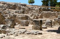 Phaistos Palace at 39.2km (SW) The complex of four rooms on the northeast edge of the Palace does not belong to the Old Palace, although it directly adjoins it. In the westernmost building is an elongated rectangular room with partitions of vertical clay slabs. Similar "cists" in the Palaces of Knossos and Zakros were used to store valuable ritual vessels. Here they were found empty. Next door, in the narrow rectangular room to the southeast, was found a clay tablet inscribed in Linear A and the famous "Phaistos Disc" bearing hieroglyphic writing. The building was therefore named the Palace "Archive" The building east of the Archive is thought to be a shrine or the archivist's residence, while the easternmost building is known as the "Potter's Workshop" because a large number of unfinished pots were found there. The intermediate building has an impressive peristyle of alternating pillars and columns. A staircase on the south side of the peristyle building connects the whole complex to the NE entrance to the Palace, which stood in this spot. Image Library
 Phaistos Palace at 39.2km (SW) The east part of the North Wing forms the workshop area of the Palace. It consists of the East Court and a complex of small rooms which are believed to be the workshops of the New Palace (1700-1450 BC). Approximately in the centre of the court are the ruins of a horseshoe-shaped kiln. The elongated rectangular building with 6 rooms on the west side of the court appears to have been used for the workshops of the kiln craftsmen. The square room on the north side of the court was the gatehouse of the northeast entrance to the Palace. It has gypsum slab flooring and benches around the walls. Behind it is a long corridor leading to the inner courtyard of the North Wing and thence to the "Royal Apartments" Image Library
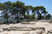
 Palace and Archaeological Site at 39.3km (SW) The archaeological site, the palace, the findings - The Festos Disc. According to mythology, Phaistos (or Festos) was the seat of king Radamanthis, brother of king Minos. It was also the city that gave birth to the great wise man and soothsayer Epimenidis, one of the seven wise men of the ancient world.Excavations by archaeologists have unearthed ruins of the Neolithic times (3.000 B.C.).
Image Library
 Found at Phaistos Palace at 39.3km (SW) The disc of Phaistos is the most important example of hieroglyphic inscription from Crete and was discovered around 1903-05 in a small room near the depositories of the "archive chamber", in the north - east apartments of the palace, together with a Linear A tablet and pottery dated to the beginning of the Neo-palatial period (1700- 1600 B.C.). The disc of Phaistos can be seen at the Archaeological Museum of Heraklion. Image Library
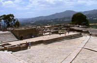
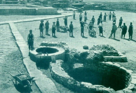
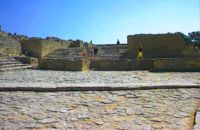 Phaistos Palace at 39.3km (SW) The large paved West Court, in front of the facade and the central entrance to the Palace complex, dates from the time of the Old Palace (1900 - 1700 BC) and played an important part in the lives of its inhabitants. On the north it is bounded by a high which also supports the Upper Court, which is on a higher level. At the foot of the wall are eight wide steps which formed the seats of what may be called a theatral area. As with the corresponding "Theatre" of Knossos, from here spectators would have watched the religious events and festivals taking place in the court. The West Court is crossed by a raised "Processional Causeway" similar to that of the Upper Court, which continues up the steps of the Theatral Area. During the time of New Palate the West Court was widened and raised to a higher level, so only 4 of its 8 steps remained visible. After the reduction of the Theatral Area, the great staircase must have been used as an additional theatral area for the events and ceremonies held in the West Court. 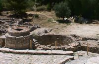 Phaistos Palace at 39.3km (SW) The south end of the West Court is occupied by four large stone-built structures known as "Kouloures" (rings) ,belonging to the Old Palace complex. The workmen on Evans' excavation gave them their name when they were first discovered at Knossos. Similar pits were also later discovered at the Palace of Malia. Their exact use is unknoun, although today they are generally regarded as depositories for offerings from the Palace shrines, or granaries. In front of the Phaistos "Kouloures" passes a "Processional Causeway" which starts in the West Court. One of the "Kouloures" is cut across by a cobbled road built in later years. The well next to them belongs to the Hellenistic period (323 - 67 BC).
 Phaistos Palace at 39.3km (SW) The main facade of both the Old and the New Palace looked onto the West Court, off which the official entrances to the Palace opened. The facade which can be seen on a lower level belongs to the Old Palace(1900- 1700 BC). It is indented according to the rules of Minoan architecture. The lower part of the walls is constructed of massive limestone blocks (orthostats). The entrance is set into a recess in the SW corner of the court. lt consisted of a monumental porch with a large central column from which a splendid corridor, paved with gypsum slabs, led to the Central Court. This old entrance is now interrupted by the buildings of the New Palace. Higher up and 7 metres further back is the facade of the New Palace (1700-1450 BC). It is constructed of large ashlars and also has deep indentations and protrusions. There are two entrances leading to the interior of the Palace. The main entrance is on the north and consists of a monumental staircase leading to the Propylaea. The other is deeply recesed and leads via a wide corridor to the Oentral Court, crossing the West Wing of the Palace 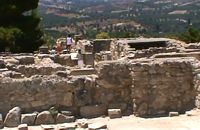 Phaistos Palace at 39.3km (SW) Almost the whole south part of the West Wing was dedicated to the shrines of the New Palace. The main architectural types of shrine are the "Bench Shrine" and the "Lustral Basin". The first type consists of small, rectangular rooms with low benches running round the walls, perhaps to support cult objects and figurines of the deity. On some of them were found female figurines, ritual vessels and "Offering Tables" (small altars). On the walls of some rooms are incised sacred symbols, such as the double Axe and the star. The "lustral Basin" type consists of rooms which are set somewhat lower than the surrounding structures, with a few steps leading down into them. The were usually lined with slabs of gypsum, giving them a highly - finished appearance. Although it is doubtful that these structures contained water, it is thought that they were used for purification rituals. There is a third type of Minoan shrine in the S-E part of the shrine wing. Its is a room with central pillars (Square, stone - built columns) thought to be a cult area, similar to the "Pillar Crypts" of the Palace of Knossos, where the sacred pillar was worshiped by pouring libations.  Psychro, Lassithi Plateau at 39.4km (SE) The cave of Psychro is one of the most important cult places of Minoan Crete. The excavators and several scholars identify the cave as the famous "Diktaian Cave", where Zeus was born and brought up with the aid of Amaltheia and the Kouretes, and which is connected with myths as this of the seer Epimenides who "slept" here, or the coupling of Zeus with Europa.
 Amari, Rethymnon at 39.5km (W) Sivritos (GR: Σίβρυτος) was an important and autonomous city of the ancient Crete. The city was built in the location that today is the village of Thronos. It was located on a hill dominating the valley of Amari. The name Sivritos is derived from the words si, that in the ancient eastern languages meant water, and the word vriti, that is of prehistoric origin and meant sweet. Therefore, Sivritos in the Minoan period meant sweet water. The derivation is also verified by the fact that near the hill where the city was located there are numerous sweet water springs.  Phaistos Palace at 39.5km (SW) The church of Agios Georgios (St. George GR: Αγιος Γεώργιος) Phalandras stands a little to the south from the Palace of Phaistos on the road to Agios Ioannis village. The church was the monastery church of the Orthodox male monastery of the same name, dated to the early Venetian period (16th century), which operated normally until its dissolution in 1821. The ruins of the fortified building complex around the church were still visible until the first decades of the 20th century. Image Library
 Archaeological Site in Messara, S-W Iraklion at 39.7km (SW) The "Royal Villa" at Ayia Triada which is situated very close to Phaistos, was built in about 1550 BC. i.e. just before the new palace at Phaistos, and was destroyed by fire in l450 BC, like all other important Minoan centres. It succeeded the first palace at Phaistos as the economic and administrative centre of the regions depriving the new palace there of this role, and appears to have had connections with Knossos. The two wings, with an open-air space between them, consisted of groups of interconnecting rooms (polythyra), storerooms and stairways. On the site of the ruins, a Mycenaean megaron, the so-called "Agora" and an open - air shrine were subsequently built. In the villa's disaster layer from the fire in 1450 BC, excavation revealed a valuable group of exceptional works of art, precious materials, records in Minoan script and seals. The famous black serpentine vessels, the "Harvesters' Vase", the "Boxers' Vase" and the "Chieftain ‘ s Cup", the wall paintings depicting the natural landscape, the sarcophagus, the bronze and clay figurines of worshipers and the copper ingots from the Treasury are among the most noteworthy findings.  Rethymno at 39.8km (W) The Monastery of Arkádi (GR:Αρκάδι) built during the last Venetian period, it consists of a large set of fortress-like buildings. The main building included the cells, the warehouses where the agricultural products were treated and stored, the stables. In a word, it was a well-equipped little fortress where people could find refuge in times of trouble. There is an impressive church, with two naves dedicated to Saint Constantine and Saint Helen, and to Our Lord. Due to the holocaust it suffered in 1866, Arkadi has become the island's most famous monastery.
Image Library
 Messara, Iraklion South at 40.1km (SW) The town of Timpaki (GR: Τυμπάκι) is located in the west edge of the plain of Messara, 65.3km away from the city of Iraklion. It is a rich and busy town with significant economic activity especially due to the early vegetables production in the wider area. There are banks, a post office, medical centers, stores, schools, hotels, restaurants, ect to cover both the needs of the locals and visitors.
 Mirabello, Lassithi at 41km (E) The village of Sissi, a picturesque village 40 km east of Heraklion and 25 km west of Ag. Nikolaos. Sissi is a beautiful fishing village with strange nature. On one side of the village the nature is wild, with a small river flowing into the sea, a number of palm trees on its banks, ducks and geese swimming peacefully. On the other side there are sandy and gravel beaches, caverns in the rocks and deep clear water, full of many kinds of fish. A place that gathers the nature of different places of Crete.
 Messara bay, Iraklion South at 41.2km (SW) Kokkinos Pirgos (GR: Κόκκινος Πύργος) is a small coastal community, 2km away from Timbaki with a nice, long sandy beach, one of the longest in Crete, and a clear transparent sea. The part of the beach to the north west of the harbour is called Makrimaliana (or Kakoskalo) and the south east part of it is called Katalyki . The harbour in front of the village of Kokkinos Pirgos, offers docking facilities for sailing and fishing boats. There are hotels, restaurants, bars, etc. across the harbour and along the beach. You can always find good fresh fish in the taverns of the village. Kokkinos Pirgos (meaning red tower) , took its name from a castle that use to be there during the Middle Ages, which was built by red clay earth.
Image Library
 Lassithi, Dikti Mountains at 41.6km (SE) The Lassithi Plateau (GR: Οροπέδιο Λασιθίου, Oropedio Lasithiou), is a high endorheic plateau, located in eastern Crete, Greece on the mountain range of Dikti at an average altitude of 840 m, and in a distance of around 55km from Heraklion and 50km from Agios Nikolaos. The plateau is elliptical in shape with an E-W axis of 11km and the N-S of 7km. The plateau of Lassithi is renowned for its exceptional agricultural produce, the thousands (almost 15000) windmills that used to be there in the past, its significant historical role and for the unique cave of Psychro also known as "Diktaion Andron". Image Library
 Messara, Iraklion South at 42km (SW) Kamilari is a quiet, traditional village, with a panoramic view to the endless olive groves of the Messara valley on the one side, and to the Libyan sea on the other side. It has been inhabited since the Minoan period. One of the seven wise men of the ancient world, Epimenidis, a great wise man and a soothsayer, lived in a small community outside Kamilari, called Metohi.
 by Richard Ellis at 42.2km (SE) This was another delightful start to a day’s walking. Rather than tramping round the perimeter which is more or less where the E4 is supposed to go, it is quite possible to take a diagonal line from the south east corner to the north west corner by taking a right, then a left, then a right etc so you end up close to Kato Metochi. This way, you get to see close up the extent of the agricultural activity going on around the plateau in the morning sunshine. You also get to see the newly formed baby frogs – fresh from tadpole status – hopping happily in the sunshine in front of my big boots. Distance: 23.5 km Time: 7 hrs. Mov av 4.7 km/hr Height overnight: 335m.(max 824m.)  Messara, Iraklion South at 42.6km (SW) Its 1000 years history comes to life for the visitor, who has the chance to admire its monuments, and old houses, perfectly preserved through the centuries. In the village square , you can sit and enjoy your coffee in the traditional coffee shop, while children can play in the playground next to the school. You can also visit the church of Agios Ioannis in the same square. There are quite few rooms for rent in the village and tavernas serving traditional Cretan dishes.
|
|||
|
| |||


C
O
N
T
E
N
T
S
O
N
T
E
N
T
S