interkriti®
YOUR GATEWAY TO CRETE
HOME
CRETE FACTS
NAVIGATE
EXPLORE

Agia Galini
Triopetra
Kissamos
Chryssi Isl.
Agia Marina
Balos
Gavdos isl.
Georgioupolis
SAMARIA
IDA Mtn
Palaiochora
Agia Roumeli
Sfakaki
Bali
Kalamaki
Matala
Lassithi
Plateau Lendas
Tsoutsouros
Vianos
Myrtos
Sfakia
Plakias
Ierapetra
Makrygialos
ZAKROS
Vai
Sitia
Agios Nikolaos
Elounda
MALIA
Hersonissos
Gouves
Chania
Rethymnon
Heraklion
GORTYN
FESTOS
KNOSSOS
|
|
Crete
List Grid Map
Found
246
- Showing :
221 - 240
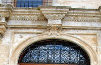 Rethymnon Old Town at 43.2km (W) The church of Saint Francis is one of the most important monuments of Rethymno. It was the main temple of the Monastery of the Franciscan Order. The architecture of the building - a single aisle Basilica type with wooden roof - and its ornaments are very interesting. Next to the east side of the temple two deserted chapels are preserved. Its Corinthian style main doorway is impressive, with capitals of composite order. During recent excavations around the church valuable archeological findings have been discovered, including two tombs of Venetian nobles. During the Turkish occupation the temple was turned into an "Imaret" (a shelter for the poor). It was also used as a cultural center until 1996. It was recently renovated to accommodate the Byzantine and Post-Byzantine Collection of the Prefecture of Rethymno. 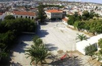 Rethymnon Old Town at 43.2km (W) The square of Mikrasiaton (GR: Πλατεία Μικρασιατών) formerly the 1st primary school square, in Rethymnon town, covers an area of 7,500 square meters, right at the heart of the city's historical center. It is surrounded by valuable monuments and beautiful buildings, mainly used as cultural centers. There, visitors have the opportunity to rest in a peaceful environment and at the same time visit the various monuments and cultural centers located in the area. Image Library
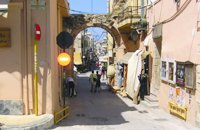 Rethymnon Old Town at 43.2km (W) The Guora Gate (Porta Guora or Grand Gate)) is the main entrance of the Venetian city walls that protected the city of Rethymno. The gate was built in the years of Rector Rettore Jocopo Guoro (1566-1568). Part of the gate is preserved at the beginning of the street "Ethnikis Antistaseos". It is 2,60 m. wide, built with carved stones with skew acnes, creating a semicircular arc on the top. According to traveler J. Gerola, the initial shape of the gate was formed by stepped cornice and pediment where a relief the lion of St. Marcos (the Venetian emblem) existed. Today the relief is preserved in two pieces and is stored at Loggia's courtyard. Old drawings of Guora Gate: inside the walls - outside the walls Image Library
 Rethymnon Old Town at 43.2km (W) The Museum of Submarine Life is situated at Arapatzoglou street, at the center of Rethymno's old city. It was founded by the "Moshaki" family, in memory of their lost child, who drowned in the sea. The largest part of the exhibits are made up of shells, while a few vertebrates, sponges and fish are also on display.
 Messara bay, Iraklion South at 43.3km (SW) A small coastal village with a long sandy beach is becoming very popular with tourists due both its natural beauty and its proximity to Phaistos, Gortys and other important sites. There are quite few hotels, apartments etc and taverns, cafes by the beach.
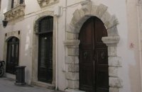
 Rethymnon old town at 43.3km (W) The Historical and Folklore Museum of Rethymno is located next to the Neratze Mosque. It is an institution of public benefit, founded in 1973 by the President of the Historical and Folklore Institution, Christoforos Stavroulakis, and Fali Vogiatzaki. The museum is housed in a restored Venetian building with an interior courtyard. The building is a wonderful piece of urban residence of the last phase of the Venetian occupation of Crete, built in the renaissance style by traditional craftsmen. Image Library
 Rethymnon city at 43.4km (W) The Institute for Mediterranean Studies (IMS) based in Rethymno, Crete, was founded in 1985 and belongs to the research units of the Foundation for Research and Technology, Hellas (FORTH). The IMS is the only FORTH centre which deals with the human and social sciences. The purpose of IMS is to support and invigorate research in the field of the human and social sciences, as well as to promote the application of advanced technologies in the field. The IMS possesses a fully equipped Laboratory of Geophysical-Satellite Remote Sensing (GIS) & Archaeo-environment, specialized in archaeological research. The Library of the Institute is focused on Turkish Studies and Art History. In the Library archival material, as well as collections of Greek and foreign newspapers in digital form and microfilms are kept. The objective of the IMS's research programs is to study the geographical space, the history and culture of Greece and the other Mediterranean countries in various historical periods, from prehistory to modern times. In order to achieve these objectives, the research projects of the Institute are organized along the following axes: Turkish Studies History Studies Art History History of the Theatre - Ethnomusicology The Laboratory of Geophysical-Satellite Remote Sensing & Archaeo-environment Its activities concern the field of geophysical research, the satellite remote sensing, the Geo-information technologies and the archaeo-environment, with emphasis on the Mediterranean region. The Laboratory is a member of international organisations such as EPOCH, EARSel. and AGILE and participates in a number of joint research and technology programs in Greece and abroad (e-Content, INTERREG, ARCHIMED, ETPA, PEWNED, EPEAEK, INSTAP, LIFE, Region of Crete). The research programs of the Institute are carried out by its permanent researchers and collaborating faculty members. In the frame of these research programs are prepared PhD Thesis and other diplomas which are submitted to the higher educational institutions with which IMS collaborates and, particularly, to the University of Crete, the Technical University of Crete and the Technological Educational Institute of Crete. The IMS supports education at post-graduate and post-doctoral level with a considerable number of annual scholarships, thus contributing to attract a steady flow of young researchers and to promote research in the field of humanities at the periphery. The IMS maintains close academic links with various international research foundations (Cyprus, Turkey, Bulgaria, Italy, France, Spain, England, Belgium, Tunesia, Egypt, China, USA, a.o.). The IMS is administered by a director and a five member academic council (A.C.). It is housed in wholly-owned premises comprising of two listed buildings in the old town of Rethymno. The core of one edifice dates back to the Venetian period (13th - 17th century). Links: www.ims.forth.gr/  Rethymnon town at 43.5km (W) The Fortezza castle, at the top of a low hill named "Palaiokastro" dominates the town. It was built in 1590 to protect the city from the pirates raids and the Turks. The name "Palaiokastro which means 'The old Castle' was in use even by the Venetians which demonstrates the existance of an even older castle at this place. - Probably the acropolis of the ancient town of Rithymna. The interior of Fortezza accommodated the following basic buildings: the storeroom of the artillery, where canons and weapons were kept, the residence of the Councilors, where one of the city's two Venetian councilors lived, the residence of the Rector, which represented a luxurious, magnificent building in the central square of the fortress. Today parts of those buildings, as well as of some others built later, can be seen. The view from up there is magnificent, especially at night. The municipal theatre "Erofili" stands also at Fortezza's premises. It is an outdoor theatre that hosts almost all the performances during the Renaissance Festival. Image Library
 Rethymnon city at 43.5km (W) Rethymnon General Hospital is situated at 17, Trandalidou Str., close to the municipal gardens. The hospital has all major clinical specialties, outpatient clinics, intensive care unit and generally offers sufficient medical services throughout the prefecture of Rethymnon.  Pediada, Iraklion at 43.6km (SE) Askoi (GR: Ασκοί) is small village in the municipality of Kasteli has 315 inhabitants. It lies in the foothills of the Dikti mountain, 11 km to the east of Kasteli and 8 km from Lyttos. Fr. Barozzi mentions it as Ascus, in the Pediada district, in 1577. Recently a ritual clay figurine of the Mid-Minoan period was fortuitously unearthed on a peak close to the village. The remains of a large building belonging to a peak sanctuary have been excavated at Amygdalokefalo to the NE of the village. A reference in a contract of 1271, mentions how Petri Comarii from the village (casali) Maski owes Ruggerino Temisano, resident in Chandax, 25 «mistata» of good Cretan wine from his vineyards in Maski. Among other natural beauties, the ravine at Aski is well worth seeing. On December 4th the village has a typical Cretan feast to honour Agia Varvara. And as in every Cretan village, raki and ‘mezedes’ are always available at the kafeneions. Image Library
 Messara, Iraklion South at 43.8km (S) The village of Pitsidia is located 65 km southwest of Iraklion at an altitude of 80 m a.s.l, just before the magnificent bay of Messara. The village with aproximately 700 inhabitants is the oldest village of the area and is refered (by S. Spanakis) that it was the place where the soldiers of Nikiforos Fokas, commander of the Byzantine army, settled. The army, famous for its bravery, came from Pisidia of the south Asia Minor, and this is probably the origin of the name Pitsidia.
Image Library
 Pediada, Iraklion at 43.8km (SE) Armacha (GR: Αρμάχα) lies at 490 m above sea level, at a distance of 7km from Kastelli, with 110 residents (census 2001) and is first referred to by Barozzi in 1577. Armacha is rich in the production of agricultural and livestock products. The Metropolitan Bishop, Tirnovos Voulgaria Ilarionas Kabanaris Sinitis was born, and is also buried here. A man of advanced learning, he wanted to translate the Bible to Demotic Greek.  Pediada, Iraklion at 44.1km (SE) Amariano, a charming small village of 321 inhabitants, (census 2001), lies in the western foothills of Afendi mountain, at an altitude of 530m. It is located at 7, 2 km east of Kastelli and can be found on the road axis; Kasteli -Xidas- Kastamonitsa-Amariano. With the traditional, century old plane tree in the middle of the village square, with the fountain, surrounded by kafeneions (traditional cafes) serving refreshments; raki (or tsikoudia, the traditional Cretan spirit) and mezedes (tit-bits), Amariano is a typical Cretan village, well worth a look. Until recently, the leather tannery was a main activity among the villagers. The main produce today are olive oil, raisins and grapes, although there is also livestock. Close by is the church of Agios Giorgos Kefaliotis with good quality wall paintings. The cultural centre of Amariano organises a great feast on August 15th, the Dormition of Theotokos and on September 20th, day of the patron saint, Aghios Eustathios. This can be a great occasion for any visitor to live an authentic cultural experience, to meet the people and taste the traditional Cretan cuisine. The first mention of the village -Amariano and Mariano- is to be found in inscriptions dating back to 1394-1399. Fr. Barozzi also mentions it in the region of Pediada in 1577. The name is significant: Amari is an area close to the town of Rethymnon, therefore the first inhabitants were originally from the Amari region. During the second Byzantine period, this region was known as Apano Syvritos and the name Amari is first mention in Venetian times. This would imply that the village was first founded during the Venetian conquest of the island. The first spelling, Amarianos, is the correct one and the family names Amarianos, Amargianitakis and Amariotis first appear in the 16th century, in the 1583 cencus. Image Library
 Pediada, Iraklion at 44.3km (SE) Kastamonitsa (GR: Κασταμονίτσα) is 7 km away from Kasteli, has 356 inhabitants and lies at 520 m above sea level, in the foothills of the Afendi mountain (1578 m), with the Dikti mountain in the background. The village is not mentioned in the Venetian registers of the 16th and 17th centuries, nor in the Turkish census of 1671. It is possible that the name is related to that of Kastamoni in Asia Minor: refugees, driven out of their land by the Turks, may well have come and settled here, giving their new home the same name as their old one. But it is impossible to establish a precise date. The Church of the Koimisi tis Theotokou (Dormition of Our Lady), located in the cemetery of the village, has wall paintings of the 14th century and points to a settlement here during the Venetian period. However, as we said before, the village is not mentioned in any Venetian census. The first reference is to be found in an Egyptian census conducted in 1834, where the village of Kastamonitsa is said to have 35 Christian families. And again in 1881, the village is said to have 320 Christian residents; no Turkish families are mentioned. The location of the village on the way to the natural fortress of the Lassithi plateau which protects all of Eastern Crete, turned the area into a battlefield during the last century. The Egyptian Pasha Hassan tried to invade the Lassithi plateau in 1822. The rebels cut him off between Krassi and Kastamonitsa, fighting him so well that he was forced to change his strategy and invade the plateau through its south side (Viannos and Ierapetra). Other fierce battles took place in and around Kastamonitsa during the 1866-67 rebellions. Finally Omer Pasha, known as the Attila of Lassithi, found a way up through the glen at Geraki where an betrayer showed him the way. A clay cast has been found in Mesarmi. It is elliptical in shape and has a width of about 0.25 m, and has a plaited decoration. A round glass vessel was also found at Xidiano Seli. 4 km out of the village you get to a lovely spot known as Mesada, where traditional celebrations take place on Easter Tuesday.The village boasts of several kapheneions and a taverna in the main square. There is an active cultural centre, that organizes events especially in the summer. The most important and traditional feast is held on July 7th in honour of Aghia Kyriaki. Image Library
 Pediada, Iraklion at 44.3km (SE) Mathia is 11 km to the SE of Kasteli, has 215 inhabitants and lies at 590 m above sea level, in the foothills of the Afendi mountain (1578 m), with the Dikti mountain in the background. The earliest reference to the village can be found in several contracts of 1271 where the notary of Chandax P. Scardon mentions commercial exchanges of grain and wine with residents of the village ‘Mithie’, possibly a misspelling for Mathia. The name derives from the common first name for girls, ‘Mattia’, which in Crete is pronounced ‘Mathia’. Burials in jars of the middle Minoan period were discovered in 1957 close to the village, in a place known as Stavroplaka. To the NW of the village, at Katalimata, a Late Minoan site with important finds and, 200 m further off, a settlement with large walls still in place were also found.There are wonderful Byzantine wall paintings in the two churches of this traditional village, the church of Koimisi tis Panagias (Dormition of Our Lady) and the church of Agios Giorgos. At Metochi, in beautiful surroundings where the historical holm-oak of Ismail Pasha stands among plane trees and running water, there are camping facilities. You can also visit an old factory and several ruined mills. The village boasts of several kapheneions where they serve raki and ‘mezedes’ (tit-bits). There is an active cultural centre, that organizes events especially in the summer, with evenings of Cretan music and theatre plays. The most important and traditional feast is held on the Sunday of Agioi Pantes, 50 days after Easter. Image Library
 Pediada, Iraklion at 44.7km (SE) Geraki (GR: Γεράκι). This lovely village of 375 inhabitants is located on the western slopes of the Lassithi mountains between the peaks of Afendi (1578 m) and Sarakinos (1588 m) in a beautiful glen, 520m above sea level and only 9km SE of Kastelli. It features an interesting Byzantine church, dedicated to the Archangel Michael (Archangelos Michail) with wall paintings that have not been maintained and some interesting (movable) icons by the local painter, Sepis. The active cultural centre of Geraki organizes many events during the summer season. Twice a year the village has a typical Cretan feast in honour of its patron saints: Agia Paraskevi on July 26th and Michail Archangelos on 8th November. The village produces agricultural products and great cheese that led to a specific cheese celebration. From Geraki you can also reach the lovely chapel of Agia Anna, driving through a particularly beautiful landscape with a spectacular view over the Geraki glen and fresh running water, a place ideal for a picnic. Image Library
 Armenoi, Rethymnon at 44.8km (W) The site was first discovered by a teacher who noticed that two pupils were playing football using a minoan vase as a ball!. He mentioned the fact to the authorities and the excavations that followed unearthed about 300 tombs of the Late Minoan III period (1450-1100 BC). As the tombs had not been yet looted, the archaeologists found significant treasures like vases, weapons, statuettes, jewels etc. It is obvious that such a big cemetery should belong to a big city which, despite the extended investigations of the archaeologists, has not been discovered yet. Image Library
 Messara Bay, Iraklion at 44.9km (SW) One of the most beautiful sandy beaches of Crete, extends from a clump of rocks riveted in the shallow waters in the south to the Kalamaki settlement in the North. In Minoan times there used to be the ancient port of Phaistos. The antiquities lie just a few meters away from the sea.
Image Library
 South Rethymnon at 46.9km (SW) The beach of Agios Pavlos is about 60 km from Rethymno and can be easily reached through an asphalt road. In fact, Agios Pavlos is a small settlement on a beautiful, picturesque cove. Around and close to the beach there are some small hotels and taverns and right on the beach a beautiful cafe / bar. West of the small settlement at a place known as Alatsogremni (Cliffs of salt) are the famous dunes of Agios Pavlos. Although dunes are not rare in the south coast of Crete, those are very impressive. High dunes that end in crystal clear, turquoise waters. A landscape of unique natural beauty that is worth seeing. The scenery is even more imposing late in the afternoon, when the sun is setting and the sand gets a golden hue. It looks like an image coming from another world. Between the small beach at Agios Pavlos and the Dunes we find the area of Apoplystra with the unique rock formations. From the beach of Agios Pavlos climb a wooden staircase and you are in front of a unique spectacle. Rocks sculpted by salt water, in various shapes and wonderful colors.  Gonia, Rethymno at 47.1km (W) The Municipality of Nikiforos Fokas is located in the north of Rethymnon Prefecture. The area is known for its outstanding natural beauty and its historical tradition and architecture. All of the municipality's settlements are steeped in history and contain fine examples of architecture, featuring stone buildings with vaulted entrances (known as "diavatika") and magnificent thresholds. The municipality's jurisdiction extends over the fourteen former community wards of Agios Konstantinos, Ano Valsamonero, Atsipopoulo, Gerani, Gonia (Athanatos), Zouridi, Kalonyktis, Kato Valsamonero, Malaki, Mountros, Prines, Roustika, Saitoures and Frantzeskiana Metochia, which comprise a total of 21 villages. |
||
|
| ||


C
O
N
T
E
N
T
S
O
N
T
E
N
T
S