interkriti®
YOUR GATEWAY TO CRETE
HOME
CRETE FACTS
NAVIGATE
EXPLORE

Agia Galini
Triopetra
Kissamos
Chryssi Isl.
Agia Marina
Balos
Gavdos isl.
Georgioupolis
SAMARIA
IDA Mtn
Palaiochora
Agia Roumeli
Sfakaki
Bali
Kalamaki
Matala
Lassithi
Plateau Lendas
Tsoutsouros
Vianos
Myrtos
Sfakia
Plakias
Ierapetra
Makrygialos
ZAKROS
Vai
Sitia
Agios Nikolaos
Elounda
MALIA
Hersonissos
Gouves
Chania
Rethymnon
Heraklion
GORTYN
FESTOS
KNOSSOS
|
|
Crete
List Grid Map
Found
120
- Showing :
41 - 60
 Gonia, Rethymno at 26.3km (NE) The Municipality of Nikiforos Fokas is located in the north of Rethymnon Prefecture. The area is known for its outstanding natural beauty and its historical tradition and architecture. All of the municipality's settlements are steeped in history and contain fine examples of architecture, featuring stone buildings with vaulted entrances (known as "diavatika") and magnificent thresholds. The municipality's jurisdiction extends over the fourteen former community wards of Agios Konstantinos, Ano Valsamonero, Atsipopoulo, Gerani, Gonia (Athanatos), Zouridi, Kalonyktis, Kato Valsamonero, Malaki, Mountros, Prines, Roustika, Saitoures and Frantzeskiana Metochia, which comprise a total of 21 villages.  Sfakia, South Hania at 27.3km (NW) The Samaria Gorge is one of the longest ravines in Europe (with a total length of 16 km) and offers one of the most spectacular hiking routes in Europe. Its width ranges from 150 m (widest part) to 3 m (narrowest part). The walk from Xyloskalo in the plateau of Omalos to the shores of Libyan sea at Agia Roumeli, takes 6 to 8 hours. The Samaria Gorge has been designated as a national park in order to protect its flora and fauna. It is one of the last shelters of the mountain goat of Crete (Cretan Ibex, common name : kri-kri). The flora is extensive, ranging from high cypress trees to flowers and herbs. The walking path follows the river which flows to small lakes and waterfalls. The Gorge is open to visitors from May to October. Image Library
 Spili, Rethymno at 28.7km (E) Spili (GR:Σπήλι) is 30 km away from Rethymnon, along the road that goes from Rethymnon to Armenoi and then Spili. The town has about 800 inhabitants and it lies at a height of 430 m above sea level, at the foothills of Mount Vorizi, which belongs to the Kedros chain. The landmark of the town is the square at Kefalovrissi with the 25 fountains each one in the shape of a lion's head. The square is named after Thanassis Skordalos (1920-1998), a popular lyra player and composer born in Spili. Spili is a modern town, with all the facilities and services required by the locals and by the large number of visitors. Image Library
 Apokoronas at 28.9km (N) A beautiful small sea side village with long sandy beach where wind surf, canoes, paddle boats, umbrellas and sun beds can be rented. The place provides all the facilities for the visitors with small hotels, rooms, apartments and many taverns with traditional food and fresh fish. Recent years it became very popular with expatriates and there is a significant development in the real estate sector.
Image Library
 by Richard Ellis at 28.9km (E) 27th August - I set off from Spili at 0740 under a rather cloudy sky and with a cooling breeze to keep me feeling fresh. Today was always going to be a bit of a road slog and the first few kms to Mixourama was on the main road with cars flashing by. The GPS suggested that there was a road link between Koxare and Agouseliana even though there was nothing on the paper map so, after 6 or 7 kms, I cut across to Koxare. Distance: 32 km Time: 8 hrs. 25mins. Mov av 4.8 km/hr Height overnight: 272m.  Apokoronas, Hania at 29.2km (N) Pláka (GR: Πλάκα) is a lovely village in the Apokoronas area, less than one kilometer away from Almyrida, with interesting architectural style, which is unfortunately changing due to intense building mainly for tourist purposes. Its ~300 permanent inhabitants, occupying mostly with farming, stock-breeding, fishing and lately with tourism. It has all the basic amenities, including excellent tavernas, bars, a grocery store and a kafeneion. Plaka is built on the slope of a hill at 70 m above sea, with a panoramic view of the bay of Souda. The surrounding environment has maintained its character well and is ideal for walks either inland or along the coast. Visitors can also admire a magical sunset from here. Every summer -at about the end of July- a two days traditional feast - The Plakiana - is organized to honour the memory of the great local lyra player Mihalis Papadakis or else Plakianos. During the feast guests enjoy Cretan dances and can visit the textile and ceramics exhibitions. The custom of Klidonas is celebrated at the end of June and the Carnival usually takes place in March.  Apokoronas, Hania at 29.3km (N) Kókino Horio (GR: Κόκκινο Χωρίο), which is located at a higher altitude, has maintained its traditional architectural style even more so than the other villages with its narrow roads, beautiful gates and tiled roofs. A group of cisterns, built in a sloping field, gather the rainwater, an interesting example of local architecture, dealing with the permanent problem of lack of water. Above Kokino Horio one can see the strangely shaped hill Drapanokefala or Calapodha (so named during the venetian occupation). The coastline northwest of the village is an extremely interesting place for a stroll due to the ground formation and the caves, such as the cave of Petsi (or Karavotopos). Another cave called Katalimata, located at the centre of the village, is also an interesting site. At cape Drapano, approximately 10 metres under water, is the impressive Elephant cave, an area 60mx60m full of stalactites and stalagmites of various shapes and colours. Video - The Elephants' Cave  Apokoronas at 29.7km (N) A flourishing traditional seaside town on the Apokoronas Peninsula 17km east of Hania. Kalýves (or Kalives GR: Καλύβες) with its old tiled stone houses, mixed with the latest buildings form two separate districts, with typical island style. Most of it is literally built on the sea and has 1289 residents. Xydás (GR: Ξυδάς) river that runs through the town, is giving it a unique character and a cool climate that prevents the heat of summer. In the square, you will see a traditional water mill built in the early 20th century, one of the oldest in the area. Kalives is tastefully developed for tourism, and welcomes many visitors during the summer season to its safe sandy beach. With comprehensive amenities, there are many shops, taverns and kafeneion, in addition to banking, post office and petrol station facilities.
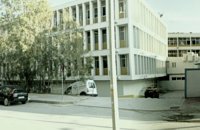 Rethymnon city at 30km (NE) Rethymnon General Hospital is situated at 17, Trandalidou Str., close to the municipal gardens. The hospital has all major clinical specialties, outpatient clinics, intensive care unit and generally offers sufficient medical services throughout the prefecture of Rethymnon.  Lefka Ori, Hania at 30km (NW) Kallérgi Mountain Refuge is located on the western region of Crete, above the plateau of Omalos, in the White Mountains (Lefka Ori) mountain range at an altitude of 1680 metres. The site is of unique natural beauty and commands great views to the surrounding peaks and the gorge of Samaria. It can be accessed by car or on foot (1 1/2 hour) via the 5km long dirt road from Omalos. The refuge can accommodate up to 50 people. It features a fully equipped kitchen, a lodge with fire place and wood burning stoves, toilets (indoors and outdoors) and a camping area. Electricity is supplied by a generator. Kalergi refuge operates throughout the year (from November to March only on weekends) For more information please visit:Mountaineering Club of Hania  by Richard Ellis at 30km (NW) 1st September - The last two days of the walk were rather low key after the drama of the White Mountains. I left Kallerghi at 0800 after a proper Austrian mountain breakfast served up by my new Bulgarian friend Daniel. It is about an hour down the dirt road to the Omalos plateau and half way down I realised I had left my beloved katsouna (shepherd's crook) at the hut. I couldn't bear the prospect of going all the way back up so I rang Joseph to say that I would collect it the following week. I have learnt that it is now forbidden to cut sticks from the wood of the rare ambelitsia tree so mine is now a museum piece (with the distinction of having walked 450 kms across Crete). Distance: 28.4 km Time: 8 hrs. 20 mins. Mov av 4.2 km/hr Height: 405m.  North West Crete at 30.3km (NE) Rethymnon (GR: Ρέθυμνον) is the capital of the Prefecture of the same name and it is built between the two other large cities of Crete. The town still maintains its old aristocratic appearance, with its buildings dating from the 16th century, arched doorways, fountains etc. The Fortezza castle, at the top of a low hill named "Palaiokastro" dominates the town. It was built in 1590 to protect the city from the pirates raids and the Turks.
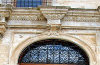
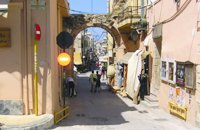 Rethymnon Old Town at 30.4km (NE) The Guora Gate (Porta Guora or Grand Gate)) is the main entrance of the Venetian city walls that protected the city of Rethymno. The gate was built in the years of Rector Rettore Jocopo Guoro (1566-1568). Part of the gate is preserved at the beginning of the street "Ethnikis Antistaseos". It is 2,60 m. wide, built with carved stones with skew acnes, creating a semicircular arc on the top. According to traveler J. Gerola, the initial shape of the gate was formed by stepped cornice and pediment where a relief the lion of St. Marcos (the Venetian emblem) existed. Today the relief is preserved in two pieces and is stored at Loggia's courtyard. Old drawings of Guora Gate: inside the walls - outside the walls Image Library
 Omalos, Hania at 30.4km (NW) Xylóskalo (Ksyloskalo GR: Ξυλόσκαλο) is the point where the Samarian gorge starts. It is located on the Lefka Ori (White Mountains) in the plateau of Omalos, 43 km from the city of Hania at 1250m above sea level. It is also the entrance to the gorge. There are two tourist lodges where visitors can rest and have food or coffee and take panoramic pictures of the gorge and the White Mountains. There is also the information center of the National Park and a parking area. Xyloskalo means the "wooden stair" and refers to a wooden staircase built by the locals in order to facilitate the entrance to the gorge as at this point the cliffs are very steep. Today this part of the path is made of stones and it has a wooden handrail. About 1km before Xyloskalo a dirt road leads, after 5 km, to the Kallergis mountain lodge at 1680m a.s.l.  Rethymnon town at 30.5km (NE) The Fortezza castle, at the top of a low hill named "Palaiokastro" dominates the town. It was built in 1590 to protect the city from the pirates raids and the Turks. The name "Palaiokastro which means 'The old Castle' was in use even by the Venetians which demonstrates the existance of an even older castle at this place. - Probably the acropolis of the ancient town of Rithymna. The interior of Fortezza accommodated the following basic buildings: the storeroom of the artillery, where canons and weapons were kept, the residence of the Councilors, where one of the city's two Venetian councilors lived, the residence of the Rector, which represented a luxurious, magnificent building in the central square of the fortress. Today parts of those buildings, as well as of some others built later, can be seen. The view from up there is magnificent, especially at night. The municipal theatre "Erofili" stands also at Fortezza's premises. It is an outdoor theatre that hosts almost all the performances during the Renaissance Festival. Image Library
 Rethymnon Old Town at 30.5km (NE) It is housed in the church of Agios Frangiskos in the center of the old town. It exhibits objects from the Neolithic to the Roman period, found at the prefecture of Rethymno (mainly Eleftherna, Monastiraki and Armeni). Clay figurines, funerary coffers, grave offerings, statues, grave steles, red-figure vases, bronze vessels, jewellery and glass vases, are some of the objects on display. St. Francis Church - 4 Agiou Fragiskou str., Telephone: +30 28310 27506 Email: efareth@culture.gr Open Winter: 08:00 - 15:00 November 1 - March 31 Summer: 10:00 - 18:00 April 1 - October 31, except Tuesday. 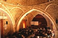 Rethymnon old town at 30.5km (NE) During Venetian occupation the mosque Neratzes, which today is used as a conservatory, was the Augustinian church of the Holy Virgin. In 1657 the Turks transformed it into the mosque 'Gazi Housein' or 'Neratze', and in 1890 they added a large minaret with two galleries, which was built from the famous stones from the village of Alfa. The chapel of the Holy Virgin, situated at its west side and dedicated to the Body of Christ, was also transformed into a seminary. Outstanding elements of this building are the doorframe and the three domes.
Image Library
 Rethymnon old town at 30.5km (NE) The Historical and Folklore Museum of Rethymno is located next to the Neratze Mosque. It is an institution of public benefit, founded in 1973 by the President of the Historical and Folklore Institution, Christoforos Stavroulakis, and Fali Vogiatzaki. The museum is housed in a restored Venetian building with an interior courtyard. The building is a wonderful piece of urban residence of the last phase of the Venetian occupation of Crete, built in the renaissance style by traditional craftsmen. Image Library
 Rethymnon Old Town at 30.5km (NE) The church of Saint Francis is one of the most important monuments of Rethymno. It was the main temple of the Monastery of the Franciscan Order. The architecture of the building - a single aisle Basilica type with wooden roof - and its ornaments are very interesting. Next to the east side of the temple two deserted chapels are preserved. Its Corinthian style main doorway is impressive, with capitals of composite order. During recent excavations around the church valuable archeological findings have been discovered, including two tombs of Venetian nobles. During the Turkish occupation the temple was turned into an "Imaret" (a shelter for the poor). It was also used as a cultural center until 1996. It was recently renovated to accommodate the Byzantine and Post-Byzantine Collection of the Prefecture of Rethymno. 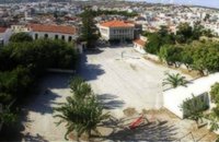 Rethymnon Old Town at 30.5km (NE) The square of Mikrasiaton (GR: Πλατεία Μικρασιατών) formerly the 1st primary school square, in Rethymnon town, covers an area of 7,500 square meters, right at the heart of the city's historical center. It is surrounded by valuable monuments and beautiful buildings, mainly used as cultural centers. There, visitors have the opportunity to rest in a peaceful environment and at the same time visit the various monuments and cultural centers located in the area. Image Library
|
||
|
| ||


;)
;)
;)
C
O
N
T
E
N
T
S
O
N
T
E
N
T
S