interkriti®
YOUR GATEWAY TO CRETE
HOME
CRETE FACTS
NAVIGATE
EXPLORE

Agia Galini
Triopetra
Kissamos
Chryssi Isl.
Agia Marina
Balos
Gavdos isl.
Georgioupolis
SAMARIA
IDA Mtn
Palaiochora
Agia Roumeli
Sfakaki
Bali
Kalamaki
Matala
Lassithi
Plateau Lendas
Tsoutsouros
Vianos
Myrtos
Sfakia
Plakias
Ierapetra
Makrygialos
ZAKROS
Vai
Sitia
Agios Nikolaos
Elounda
MALIA
Hersonissos
Gouves
Chania
Rethymnon
Heraklion
GORTYN
FESTOS
KNOSSOS
|
|
Crete
List Grid Map
Found
246
- Showing :
101 - 120
 Central Iraklion at 30.4km (E) The town of Arkalochori (GR: Αρκαλοχώρι) with a population of 2.881 is located 33km away from Heraklion, on the provincial road linking Heraklion and Viannos, at 395m above sea level. Its inhabitants are mostly involved in agriculture, but in commerce and arts as well. Arkalochori is one of the most developing towns in the prefecture of Iraklion both in economic and cultural sectors and is the administrative center of the area. Events such as the Pancretan Agricultural and Commercial Exhibition, that takes place here are of great significance and interest for the whole island. The town offers a full range of modern facilities to its residents and visitors.
Image Library
 Myrtia. Iraklion at 30.5km (NE) The Nikos Kazantzakis Museum is dedicated to the great Greek writer, poet and philosopher Nikos Kazantzakis. It was founded in 1983 and it is located at the village Myrtia in Iraklion, next to his father's house. The museum contains some of his personal belongings (pipes, glasses, pens, etc.) and a rich collection of his manuscripts and letters, first Greek editions of his books, documents from theatrical productions of his works, copies of TV series and movies based on his novels, portraits of Nikos Kazantzakis, copies of press releases and articles on his life and work.  Arkalohori at 30.8km (E) A modern exhibition and congressional centre offering 8000 square meters of total space, 1500 of them being indoors. Among many events that take place in this centre is the Pancretan Agricultural and Commercial Exhibition of Arkalochori held every two years at the end of August. The exhibition attracts a large number of enterprises, manufacturers and services participating and is being visited by over 30,000 visitors from all over Crete. It is considered to contribute essentially in the rapid commercial and cultural development of the wider area. Photo The Municipal Open Theatre Located in the area of the exhibition centre the theatre is of semicircular shape with a capacity of approximately 1000 seats. The facility offers also a canteen, toilets, dressing-rooms for the actors, store room of scene and backstage.The cultural events that the Municipality organises every summer, attract visitors not only from the wider area but also from Iraklion city. Photo Photo Monastiraki (The archaeological site) Amari at 31.2km (NW) Monastiraki lies in the valley of Amari, on the natural route leading from northern Crete to the Messara plain. Excavations have brought to light a centre of the Old Palace period (1950-1700 B.C.). which was destroyed by fire following an earthquake. The large number of storerooms and the existence of two archive rooms with many clay sealings indicate a palatial character for the site. Other finds on the top of a neighbouring hill suggest there must have been a religious centre in the area, as well. Image Library
 Monofatsi, South Iraklion at 31.2km (E) Maridaki (GR: Μαριδάκι) is a small coastal hamlet in the bay of Tsoutsouros on the southern coast of Iraklion prefecture. It is built at the end of the gorge of Ahendrias.
Image Library
 Iraklion at 31.6km (NE) The TEI, located on the beautiful island of Crete, was founded in 1983 in order to provide Higher Technical Education to the students of Greece. Since then it has expanded and developed considerably, and now comprises the Schools of Applied Technology (also in Chania and Rethimno) Health & Welfare Services Management & Economics (also in Agio Nikolao and Ierapetra) and Agricultural Technology assisted by he Departments of General Sciences, Foreign Languages and Physical Education. Students at the TEI follow courses for 4 years including lectures and practical work in laboratories. In addition, they complete a work placement and dissertation before graduating. Education at the TEI offers up to date training in technological subjects and prepares students to develop into skilled, responsible and qualified members of society. With a permanent teaching staff of 200 and approximately 10.000 students the TEI of Heraklion is a thriving academic community with an extensive library, student halls of residence, sport facilities and a health center. P.O. Box 1939 IRAKLIO, Crete, Greece, GR 710 04 Tel: Fax: +30 281 0379328 http://www.teicrete.gr  Malevizi, Iraklion at 31.6km (N) Dóxa (GR: Δόξα) is a pretty village built on a height of 400 metres above sea-level and 20 kilometres to the west of Heraklion on the road to the mountainous Milopotamos. The historical cave of Dóxa (GR: Δόξα) is located in a short distance from the village of Marathos on the road to Heraklion. It is at a height of 490 metres above sea-level, near a well-known taverna also called DOXA. The cave has a total length of 50 metres and impressive stalactites and stalagmites.  Messara Bay, Iraklion at 31.8km (W) Two small dry and uninhabited islets off the bay of Messara, ~7.5 naut. miles to the west of Matala. Due to their close proximity to one another the two islands appear as one from a distance. They are also called "elephantaki" as from north they look like a baby elephant that is lying down. In mythology it is believed that the goddess Lito gave birth to the god Apollon and the goddess Artemis on these islands. In antiquity they were called Dionissioi after the god Dionissos. During the summertime there are small cruising boats that bring tourists here from Agia Galini and Kokkinos Pyrgos. There is only a small beach with fine pebble and rich seabed at the south side of the easternmost islet.  Monofatsi, South Iraklion at 32km (E) Tsoutsouros (GR: Τσούτσουρος) is a small village on the southern coast of Iraklion prefecture, with lovely beaches and a small harbour. The ancient city of Inatos, used to stand were Tsoutsouros is now. Inatos served as a port to Priansos a renowned city - state of the Hellenistic time, located near the village of Kasteliana. Tsoutsouros is a popular tourist resort especially with Greek families. There are many taverns and cafes most of them around the small harbour, and a good choice of apartments and hotels along the beach. Image Library
Petra & Fos pizzeria - cafe bar Tsoutsouros at 32.1km (E) Delicious pizza in the wood heated oven, wonderful surroundings, ice cold beer, just by the libyan sea.
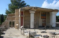
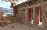
 Palace and Archaeological site at 32.6km (NE) The famous Palace of king Minos and the centre of the Minoan civilisation 5km south of Iraklion. The Great Palace covered an area of 20.000 sq. meters and had 1.400 rooms. Every section of the Palace had a specific use. In the west side of the Palace were the chambers of the ceremonies, of the administration and of the public storehouse...
Image Library
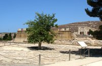 Knossos Palace at 32.6km (S) The court is crossed by the so-called "Processional Causeways", which stand out from the rest of the paving and intersect each other. One idea is that processions paraded along them during ceremonies. The West Facade of the Palace rises up along one side. The facade is constructed of massive gypsum blocks (orthostats) set on a plinth. The facade is indented or protrudes corresponding to the interior arrangement of space. In front of the West Façade, two bases can be seen, thought to belong to stone-built altars. Settlement remains of the Neolithic (6700 - 3200 B.C.) and pre-palatial (3200 - 1900 B.C.) periods have been found beneath the level of the "West Court". Image Library
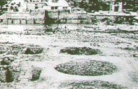 Knossos Palace at 32.6km (S) Three large pits, known as "kouloures" (rings), with stone-lined walls were built in the West Court during the Old Palace period (1900-1700B.C.). The excavation workmen gave them their name and A. Evans kept it. The function of the circular pits is not clear. They have been interpreted as rubbish dumps either for all the refuse from the Palace or just the left-overs from sacred offerings. Support has also been given to the idea that they were storing grain. In two of them, it is possible to see the remains of houses of the Pre Palatial period (3200-1900 B.C.). In the New Palace period (1700-1450 B.C.),the "kouloures" were covered over and out of use. Image Library
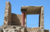
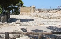 Knossos Palace at 32.6km (S) The "West Porch" was a roofed area opening onto the Court, supported by one column of which part of the gypsum base remains. The east wall was decorated with a bull-leaping fresco. There was a small "guard-room" at the back. The porch was closed off by a double door and from here began the long "Corridor of the Procession". Image Library
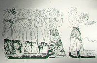 Knossos Palace at 32.6km (S) The Corridor of the Procession is named from the wall painting decorating its east wall and depicting a procession of musicians and other people holding gifts. The floor was very fine. The "Corridor of the Procession", according to Evans, initially led to the "South Propylaeum" and continued on to the Central Court. Today a causeway made of wood, with handrail, stands in its place, so the visitors can follow the same route. Image Library
 Knossos Palace at 32.6km (S) The "South Propylaeum", as we see it today, is a result of the restoration of Evans who put up a copy of the "Cup-Bearer" fresco here. The wall painting depicted a man holding a libation vase (rhyton). Its theme is connected with the "Procession Fresco" which, according to Evans, reached here, the "South Propylaeum". The pithoi (large storage jars) on the east side of the Propylaeum belong to the Postpalatial Period (1450-1100 B.C.), and indicate that the area was later used for storage.
Image Library
 Knossos Palace at 32.6km (S) The south part and south facade of the palace is very eroded. Today one can only see foundations on tiered levels. At the bottom, a tower-like projection is all that remains of the south entrance to the Palace. An asceding corridor led to the Central Court. The section of the corridor closest to the Central Court was reconstructed by Evans who put here a copy of a relief wall painting, of which only few fragments were found. On these fragments, it was possible to make out a figure wearing jewellery in the shape of lilies. The reconstruction we see here is uncertain. In Evans's opinion, it represented the "Priest-King". Other scholars think that it is a prince, whilst others believe it depicts a female figure. Anyway the original fresco which is known as the "Prince of Lilies" is one of the masterpieces in the collection of the Heraklion Museum. Image Library
 Knossos Palace at 32.6km (S) North of the South Propylaeum, at a lower level there is the start of the corridor that joins eighteen long and narrow storerooms, covering an area of 1300 sq.m. In the floor of both the storerooms and corridor, there are ninety three rectangular cists, the so called "Kasellas". From the finds it appears they were used for keeping safe precious equipment and vases. There are also even larger cists in the corridor, internally lined, perhaps to hold liquids. The pithoi (large storage jars) of the "West Magazines" bear witness to the wealth of the palace. The remains of some 150 pithoi were found, although there is room for about 400. Their contents are unknown, although they could have oil, wine, pulses, etc. At different points of the magazine, clay tablets came to light in the Linear B script with records of an economic character. At the north end of the corridor, a large number of older clay seal impressions and clay tablets in the Cretan Hieroglyphic script were discovered. Image Library
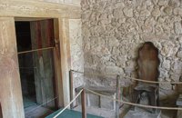 Knossos Palace at 32.6km (S) The antechamber of a complex of rooms that Evans named the "Throne Room". Its name comes from the stone seat found in the room behind the antechamber, and between them were discovered traces of a burnt wooden construction. Today, a wooden seat has been placed here which is a copy of the stone one in the neighbouring chamber. After the antechamber is the central room of the complex. Right and left of the stone seat are yet more stone benches. Pieces of fresco depicting plants and griffins, mythical beasts with a lion's body and bird's head were found in the same room. The restored fresco is in Heraklion Museum. Evans put a copy in its place. Stone vases for oil, often connected with rituals, were found on the floor. The stone basin you see was actually found in a neighbouring corridor and placed here. To the left, a low partition wall with a purification ceremonies and therefore called them "Lustral Basins". The central room connects at the back with a series of small, dark rooms which were lit by lamps, as the finds illustrate. The function of the complex is difficult to determine. Evans believed that the rooms were used for ceremonies with the main figure being the king of Knossos in his religious capacity. However, it seems unlikely to have been a Throne Room in the modern sense of the word. Image Library
 Knossos Palace at 32.6km (S) To the south of the Throne Room and the stairs, lies the area that has been identified as a shrine, called by Evans the "Tripartite Shrine" (Evans's restoration drawing). Its facade had columns and was divided into three parts, the central element being the highest. There is a depiction of a comparable shrine on a wall painting now on display in Heraklion Museum. Inside the shrine were found clay tablets in the Linear B script and clay seal impressions which were possibly connected with the archive of a shrine. The remaining areas behind the "Tripartite Shrine" are thought to have been connected with the sanctuaries of the palace. At the back, two small dark rooms with pillars are known as the "Pillar Crypts". The depresions in their floor are said to indicate that these rooms were used for libations. In another room, two large, rectangular, stone-built repositories were found, sunk into the floor. They were full of clay vases and valuable objects, amongst which were the statuettes representing the "Shake Goddess". The repositories have been interpreted as the "Temlple Repositories". The stairs on the right lead from the Central court to the upper floor of the West wing. This is largely reconstructed by Evans. Image Library
|
||
|
| ||


)
)
)
)
C
O
N
T
E
N
T
S
O
N
T
E
N
T
S