interkriti®
YOUR GATEWAY TO CRETE
HOME
CRETE FACTS
NAVIGATE
EXPLORE

Agia Galini
Triopetra
Kissamos
Chryssi Isl.
Agia Marina
Balos
Gavdos isl.
Georgioupolis
SAMARIA
IDA Mtn
Palaiochora
Agia Roumeli
Sfakaki
Bali
Kalamaki
Matala
Lassithi
Plateau Lendas
Tsoutsouros
Vianos
Myrtos
Sfakia
Plakias
Ierapetra
Makrygialos
ZAKROS
Vai
Sitia
Agios Nikolaos
Elounda
MALIA
Hersonissos
Gouves
Chania
Rethymnon
Heraklion
GORTYN
FESTOS
KNOSSOS
|
|
Crete
List Grid Map
Found
246
- Showing :
141 - 160
 Iraklion at 32.9km (NE) The monastery of Agaráthou (GR: Μονή Αγκαράθου), dedicated to the Virgin, stands at an altitude of 538m, on "Soros Panteli", a rocky hill between the villages of Sgourokefali and Sabas, 23 km from Heraklion. During the period of Venetian rule it was a centre of learning, producing many famous churchmen including the Patriarchs Cyril Lucaris, Meletius Pegas and Sylvester the Cretan. The church was rebuilt in 1894 and flourished once more after the end of the Turkish occupation. Young, educated monks with university degrees have recently settled in the monastery, restoring it to its former glory.  Krassas, Tsoutsouros at 33.3km (E) Palm House is a beautiful stone-built house on the south coast of Ceete. It is built on a tree-lined plot with panoramic sea views ,ideal for comfortable accommodation for 4 people. Its distance from the sea is only 300 meters.
 Krasas, Tsoutsouros at 33.4km (E) Seaside Houses located an hour drive (60kms) from Heraklion's airport at Tsoutsouros village. The houses are on the top of a headland separating two bays with magnificent beaches - the one almost private! - constituting a majestic scenery of virgin Crete with both sea and mountain view. Unique place for those who seek privacy, peace and romantic mood. The houses are fully equipped and have large shaded verandas. Prices from € 160/ night (2people)  North - Central Crete at 33.5km (NE) Iraklion (Heraklion or Herakleion GR: Ηράκλειον) is the largest urban centre in Crete, the capital of the region and the economic centre of the island. The first European civilisation, the Minoan civilisation, flourished on this land 5000 years ago. Currently the population of Iraklion is approximately 150.000 people. It is a very dynamic and cosmopolitan town, particularly during the summer period when thousands of visitors can be seen shopping in the market or visiting the museums and other places of interest. Today Heraklion is the top choice for tourist destinations in the Mediterranean. The city is also the commercial and scientific centre of the island. During the last 20 years the city has made remarkable progress in the academic and technological fields...
Image Library
 Iraklion at 33.7km (NE) Capacity: 26,240 (seated)- Location: The stadium is located in Heraklion (also: Iraklio) 3 km west of the city centre (at Lido beach)... The building began 15 years ago and the 2004 Olympic Games proved to be the golden opportunity for the Pancretan, as the Athens Organising Committee named it as one of the venues of the football tournament. It was inaugurated on 31 March 2004, when it hosted an international friendly match between the National teams of Greece and Switzerland. The stadium is currently the second largest stadium of the country. The stadium is actually part of a sports complex. A training ground with an 8-lane athletics track, Lido Indoor Hall, and a swimming pool are located right next to the Pancretan Stadium. Image Library
 Iraklion at 33.7km (NE) Established in 1927, AGRUNION is one of the largest agricultural cooperative unions of Greece, with 167 members of 1st degree and over 47.000 members (farmers). Its range of products include olive oil, wines, vinegar and table grapes, sold into the Greek and foreign markets. They are produced in new-built factories equipped with foremost technological equipment, totally owned by AGRUNION. 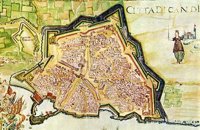 Iraklion at 34.3km (NE) The fortified enclosure of the Venetian Chandakas of the 15th century, which is still preserved today, is one of the most significant monuments of its kind in the whole Mediterranean basin. Triangular in shape, with its base at the sea, the mighty enceinte has a perimeter of about 5.5 kilometres. The hallmark of the defensive layout are the bastions, linked by curtain walls decorated at many points by escutcheons and the lion of St. Mark, symbol of Venetian omnipotence. The gates in the enceinte, which served to link the town to the countryside, still stand as important architectural monuments. To this day, the walls that withstood the Ottoman siege in the mid-17th century mark out the boundary of the old town.  Iraklion at 34.3km (NE) The bastion heart shaped in plan with an acute angle, has two "piazza bassa" and one cavalier. It defines the southeast and the highest part of the fortification. Its name is due to Gabriele Tadini Martinego (1520) who started the construction of a circular tower at the place of the later bastion. It was one of the strongest bastions (the others were that of Pantocratora and that of Vittouri) which also suffered the main attack and most of the bombardment from the Turks. On the top of the bastion itself there was made a cavalier (which looks like a smaller bastion), whose main purpose was the better defense and control of the area around the bastion. The grave of Nikos Kazantzakis, the famous Cretan writer, is situated on the highest point of the Venetian fortification at the Martinego cavalier. The inscription by the wooden cross reads: " I hope for nothing. I fear nothing. I am free ", a phrase taken from "The Odyssey" which Kazantzakis considered as one of his most significant works. The playgrounds of the Academy of the local football team "Ergotelis" are located today on the main bastion and in the ditch around the bastion are the botanical gardens of the city. Image Library
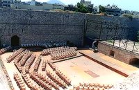 Iraklion at 34.4km (NE) Behind the "N.Kazantzakis open theatre", in the low square of the Gate of Jesus, was made after the proposal of Manos Hatzidakis and the design of Dionysis Fotopoulos, the Small Open Theatre, that recently named after the famous composer. It is constructed in a way so that is not caused damage in the Venetian Walls, that have been characterized as preservable monuments. In the "Manos Hatzidakis open theatre" (400 - 450 seats), as in "N.Kazantzakis open theatre" a lot of important events took place during the Heraklion Summer Festival.  Mylopotamos, Rethymno at 34.4km (N) Apladianá (GR: Απλαδιανά) is a small village built at the foot of the two Kouloukona heights. The settlement stretches out along the old national road, where it developed after the opening of the new national road. It comprises cafes, tavernas, and accommodation facilities included in the Countryside Tourism programs. It is worth your while, however, to visit the old village, climbing there on foot or by car. Picturesque, narrow streets, wonderful old houses with interesting architectural elements, old cisterns and churches will reward your efforts. The old village built on a height of 260 m above sea-level has 175 inhabitants and the settlement along the old national road, known as "Kampos ton Apladianon", has 78 inhabitants. It is 40 kilometres away from Rethymnon and is located at the foot of the highest peak of the Kouloukona mountain in the Tallaios range. Historical background Already as far back as 1368 we find a mention of the Aplada family, the founders of the present village and in the topographical maps of the Civil Engineering Services of Rethymnon it figures as Pladiana. The settlement is not mentioned in the 16th and 17th cent. documents. In the 1881 census, Apladiana is attributed to the commune of Garazo, with 57 inhabitants and in 1900 it is referred to as the Apladiana Commune which, together with the Cheliana settlement, had 153 inhabitants. 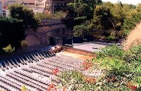 Iraklion at 34.4km (NE) Oasis is the part of the ditch of the new Venetian fortification that corresponds to the Rampant of Jesus. East of the entry of Oasis is the Cyprus square, roughly 600m from the centre of the city. For the first time, Oasis functioned as a small theatre during the 2nd world war when enough pines were cut. Then, up to 1963, a lot of assemblies took place here, mainly political. In 1963, the first serious effort of exploitation of Oasis as summer theatre, which was maintained up to 1976. In 1976 the theatre was created with the form that it has today. It became a modern open theatrical space of 1200 seats with all the necessary comforts.
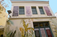 Iraklion city, Heraklion at 34.7km (NE) In the heart of the city center of Heraklion, opposite the church of Agios Minas, is the Museum of traditional music, instruments, research & documentation with the characteristic title 'Thirathen'. The Museum was founded in 2012 with its headquarters in the historic village of Krousonas, in the Municipality of Malevizi. In December 2023, it opened its doors to the public, in its new space in the center of the city of Heraklion.  Iraklion Old Town at 34.7km (NE) The Cathedral of St. Minas:The small church of St. Minas did not meet the religious needs of the constantly growing Christian community, so the demand arose for the erection of a new cathedral. The plot for the new church used to be a garden that belonged to a Turk from whom it was bought. The architect was Athanasios Moussis and in 1862 the foundation stone of one of the most magnificent and impressive Greek churches was laid. The outbreak of the Cretan revolution of 1866 demanded the stopping of the building work which will continue in 1883 in order to be completed in 1895, when the inauguration of the exquisite temple took place. The church is of the cruciform type with a dome based on a high spandrel, while internally there are also elements of a three aisle basilica. It has two bell towers, one in the northeastern corner and the other in the southeastern one. The right aisle is dedicated to Apostle Titos and the left one to St. Ten Martyrs of Crete. The inside of the church has gone through many changes with new additions. With plans of the architect Anastasios Orlandos the woodcut icon screen was replaced by another one made of marble, the same happened with the bishop's seat. The religious painting of the church was assigned to St. Kartakis who followed faithfully the principles and the models of the Byzantine icon painting. The hundredth anniversary from the inauguration of the Cathedral Church of St. Minas (1995) was celebrated with every solemnity that is suited in an equal occasion and more specifically to one of the most glorious and imposing Greek churches. Image Library
 South Rethymnon at 34.8km (W) The beach of Agios Pavlos is about 60 km from Rethymno and can be easily reached through an asphalt road. In fact, Agios Pavlos is a small settlement on a beautiful, picturesque cove. Around and close to the beach there are some small hotels and taverns and right on the beach a beautiful cafe / bar. West of the small settlement at a place known as Alatsogremni (Cliffs of salt) are the famous dunes of Agios Pavlos. Although dunes are not rare in the south coast of Crete, those are very impressive. High dunes that end in crystal clear, turquoise waters. A landscape of unique natural beauty that is worth seeing. The scenery is even more imposing late in the afternoon, when the sun is setting and the sand gets a golden hue. It looks like an image coming from another world. Between the small beach at Agios Pavlos and the Dunes we find the area of Apoplystra with the unique rock formations. From the beach of Agios Pavlos climb a wooden staircase and you are in front of a unique spectacle. Rocks sculpted by salt water, in various shapes and wonderful colors.  Iraklion at 34.8km (NE) Agia Ekaterini church and Exhibition of Byzantine Art and Ecclesiastical objects. A small sinaitic church of St. Catherine with a Basilica design, houses an exhibition with works of art from the Cretan renaissance. Among the exhibits are some of the most important icons of the Cretan School, ecclesiastical books and manuscripts, vestments, ecclesiastical vessels and relics, wall-paintings, wood-carvings and sculpture. 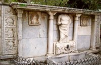 Iraklion at 34.8km (NE) It was made by "capitano" Gianmatteo Bembo between 1552-1554, it dominates in today's Kornarou square, next to a later Turkish philanthropic fountain. It is decorated with coats of arms and other elements of the renaissance and of gothic type, while in the middle a big headless statue stands out of the roman period. The spring is ornated with floral and embossed elements.
Image Library
 Kornarou square, Iraklion City at 34.8km (NE) It was built in 1776 by Hadji Ibrahim aga. In order to keep it working, he dedicated almost all his property. It is unique in its kind that is still preserved today. It is of a circular type building with a "tholos" and around the walls there are semi-circular windows with rails, in front of each one of them there exist a tap with a stone basin for the water to be collected. Today it is used as a coffeehouse.
Image Library
 Iraklion at 34.9km (NE) The Emmetropia Mediterranean Lasik Eye Clinic, a private-sector ophthalmic surgery clinic, offers advanced vision correction in a patient-centered environment. Access to conventional and cutting-edge refractive surgery technologies such us Lasik, Lasek and more, for a wide range of vision problems, enable our physicians to optimize results by meeting each patient´s individual needs. 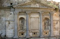 Iraklion at 34.9km (NE) The «General Provisioner» Antonio Priuli made it in 1666 and it is situated today behind the "Bodosakeio" Primary School (in the area of the Venetian Dermata Gate). He decorated it with round and square columns with Corinthian type capitals, while a triangular pediment crowns the whole construction. From both sides of the columns there are niches with their metopes elaborately decorated. In the middle of the fountain there is a Turkish inscription where there is a reference to the name of the Turkish pasha who managed to bring water again in the fountain.
 by Richard Ellis at 34.9km (NW) 26th August - You get to see Kedros close up and enjoy fabulous views back over the Amari Valley to Psiloritis and forwards over the high, little-visited plain above Spili. Once off dirt roads, the path is generally pretty clear on the ground but as ever the GPS helped me not to stray too far. As you come up out of Yerakari on the Spili road (a tempting ten kms) you take a left just after a fresh water fountain and immediately by a large cistern. There are many distracting side roads along here but you stay with the main dirt track as it winds close under Kedros before turning west. Distance:20km Mov av 4.6 km/hr Height overnight: 402m. Max. height:1,050 m Start at 680m |
||
|
| ||

C
O
N
T
E
N
T
S
O
N
T
E
N
T
S