interkriti®
YOUR GATEWAY TO CRETE
HOME
CRETE FACTS
NAVIGATE
EXPLORE

Agia Galini
Triopetra
Kissamos
Chryssi Isl.
Agia Marina
Balos
Gavdos isl.
Georgioupolis
SAMARIA
IDA Mtn
Palaiochora
Agia Roumeli
Sfakaki
Bali
Kalamaki
Matala
Lassithi
Plateau Lendas
Tsoutsouros
Vianos
Myrtos
Sfakia
Plakias
Ierapetra
Makrygialos
ZAKROS
Vai
Sitia
Agios Nikolaos
Elounda
MALIA
Hersonissos
Gouves
Chania
Rethymnon
Heraklion
GORTYN
FESTOS
KNOSSOS
|
|
Crete
List Grid Map
Found
243
- Showing :
141 - 160
 Apokoronas, Hania at 37.6km (W) Crete's only freshwater lake, Lake Kournás (GR: Λίμνη Κουρνά), is relatively large, with a perimeter of 3.5 km. Although almost all touristic leaflets say that it is possible to walk around the lake, that is not true. At least not at the end of the rain season (winter). There is a nature preserve on the Southwest of the lake. But there is a rustic road from the North of the lake to the Hills on the West of the lake too. Image Library
 Sfakia, South Hania at 37.6km (W) Kalikratis is a small mountainous village at the foot of the White Mountains (Lefka Ori) at an altitude of 750m above sea level. It is a traditional village with many well preserved stone houses. A German army of two thousand soldiers, invaded the village during the October of 1943 , burned it down and executed twenty men and nine women who did not manage to leave on time. A little to the south of the village starts the gorge of the same name which is part of the European hiking footpath (E4) and after some 4km walking ends at the village of Patsianos.  by Richard Ellis at 38.1km (E) 10th June- I packed up the tent early after a noisy night of competing dogs and was on the road by 0615. After 3 or 4 kilometres on a mix of dirt roads and tarmac roads, I managed to find the concrete road which is the official E4 (marked with paint on a concrete watertank) up from Pirgos and a couple of hours later I was in Venerato having a frappe in the café by the turn to Kerasia.. Distance:35.8km Time: 13.75 hrs. Mov av 3.9 km/hr Height overnight: 945m. Max. height: 1600m  Voutes Iraklion & Rethymno at 38.2km (E) The University of Crete, is multi-disciplinary, research- oriented Institution, situated in the cities of Rethymnon and Heraklion. It is a University with a well-known reputation both nationally and internationally, with state-of-the art curricula and graduate programmes, considerable research activity and initiatives that reflect its dynamic character. It was established in 1973 and operated during the academic year 1977-1978. Today, approximately 10628 students attend the University. The University's staff consists of 580 Teaching and Research Staff members. Its' operation is supported by more than 400 administrative staff.  Stavrakia, Iraklion at 38.2km (E) The University Hospital of Heraklion (Pa.G.N.I.) is the largest hospital facility in Crete and one of the largest public hospitals in the country. The Pa.G.N.I. provides secondary and tertiary health care in a wide range of clinical specialties, diagnostic and laboratory tests. It is located 8km away from the city of Heraklion in the area of Stavrakia, next to the School of Medicine of the University of Crete Telephone: +30 2813 402111 & 2810 392111 Website: www.pagnh.gr/  Iraklion at 38.5km (E) Ammoudara (GR: Αμμουδάρα) is four kilometre long sandy beach that stretches from the west end of Heraklion to Linoperamata near the village of Gazi. The sand is fine and blond and extends several metres to the land and the sea is clear and safe. The predominant winds during the summertime are N, N-W usually "meltemi" that get more fresh at the western end of the beach, where the windsurf school is located. Along the shore there are hotels, some of them very large complexes, taverns, restaurants, bars, cafes etc that offer umbrellas and sun-beds on the beach. There are also lifeguards in some spots. The area in general is touristic and offers a full range of facilities, among them the modern multiplex "Technopolis" with cinema and an open-air theater. Image Library
 Iraklion at 39.1km (E) The town of Profitis Ilias (GR: Προφήτης Ηλίας), or Roka for the locals, is found 20km south of Heraklion It is built on the top of two hills offering an unforgettable view to the surrounding areas. A natural fortification, due to its position, it has been suggested that ancient Lycastos was built here. It is also known as Kandli Kasteli due to the castle located at the summit of a rock southeast of the town. Nikiforos Fokas built the Byzantine castle of Temenos in the same location in 961 when he freed the island from the Saracens. His objective was to bring the city of Hantaka (Heraklion) into the castle of Temenos. However, this did not materialize and the city remained were it was. In the thirteenth century the castle of Temenos was occupied by the Genoese Pescatore, and later by the Venetians. The name Kanli Kastelli in Turkish means blood-painted castle, and took its name from a massacre of Turks by the Venetians and Greeks that took place here in 1647.  Apokoronas, Hania at 39.9km (W) Georgioupolis lies at the northern coast of Crete, about 35km away from Hania and 20 km from Rethimno. It is a nice coastal village situated at the bay of Almiros, in a lovely green scenery. It has a sandy beach and attracts quite a few visitors in the summer time. It provides all the necessary facilities to the tourists.
 Sfakia, South Hania at 40km (W) On the south coast of Crete, on a magnificent white sandy beach, stands one of the most beautiful Venetian fortresses, Fragokastello, built in 1371. It is located approximately 170 km from Iraklion, 70 km from Rethimnon, and 70 Km from Hania. Today, Fragokastello is a small, but developing, community, with nice beaches covered in sand dunes, and limited, but increasing, tourist facilities.The Villages Patsianos and Kalikratis, the castle, the history of the place and the fenomenon of Drossoulites...
 Iraklion South at 40.1km (SE) A long beach west of Lendas on the south shores of Iraklion. The name is probably a corruption of Dysikos (GR: Δυσικός) which is the one to the west. There is a small settlement with taverns and accommodation complexes, mostly rooms and apartments for rent. Dyskos used to be popular with nudists and nature lovers in the past and even in present days nudism is tolerated in the western part of the beach. The beach has small pebbles and sand. Those who chose Dyskos for their holidays will have, among other things, the chance to explore the area by small walking tours and enjoy the magnificent sunset.
Image Library
 Iraklion at 40.3km (E) The TEI, located on the beautiful island of Crete, was founded in 1983 in order to provide Higher Technical Education to the students of Greece. Since then it has expanded and developed considerably, and now comprises the Schools of Applied Technology (also in Chania and Rethimno) Health & Welfare Services Management & Economics (also in Agio Nikolao and Ierapetra) and Agricultural Technology assisted by he Departments of General Sciences, Foreign Languages and Physical Education. Students at the TEI follow courses for 4 years including lectures and practical work in laboratories. In addition, they complete a work placement and dissertation before graduating. Education at the TEI offers up to date training in technological subjects and prepares students to develop into skilled, responsible and qualified members of society. With a permanent teaching staff of 200 and approximately 10.000 students the TEI of Heraklion is a thriving academic community with an extensive library, student halls of residence, sport facilities and a health center. P.O. Box 1939 IRAKLIO, Crete, Greece, GR 710 04 Tel: Fax: +30 281 0379328 http://www.teicrete.gr  Lentas, South Iraklion at 40.3km (SE) The first habitation of the site dates from the Neolithic and Early Minoan period (3rd millenium B.C.). In the late Classical period (beginning of the 4th century B.C.) the Gortynians established the sanctuary of Asklepios at the harbour. During the tremendous earthquake of 46 B.C. the city was destroyed and subsequently rebuilt. In the Early Christian and Byzantine periods, a small settlement developed and the basilica was erected. The most important monuments of the site are: The Temple of Asklepios., the "Treasury"., the Fountain, a large, three-aisled basilica, an Early Minoan settlement (2600-2000 B.C.), the West Stoa, the North Stoa, the Nymphaion and two large, mud-brick cisterns.  Iraklion South at 40.4km (SE) Léndas or Léntas (GR: Λέντας), positioned almost in the centre of Cretes' south coast, clusters around a pretty bay that's dominated by an enormous rock resembling a lion's head that juts into the sea on one side of the resort. The village offers most facilities you might need during your stay; a choice of tavernas, three or four directly on the beach, two or three bars, mini-markets and even an Internet café. There is a sand/shingle beach and the sea is crystal clear and perfect for snorkeling.
Image Library
 Iraklion at 41.2km (E) Capacity: 26,240 (seated)- Location: The stadium is located in Heraklion (also: Iraklio) 3 km west of the city centre (at Lido beach)... The building began 15 years ago and the 2004 Olympic Games proved to be the golden opportunity for the Pancretan, as the Athens Organising Committee named it as one of the venues of the football tournament. It was inaugurated on 31 March 2004, when it hosted an international friendly match between the National teams of Greece and Switzerland. The stadium is currently the second largest stadium of the country. The stadium is actually part of a sports complex. A training ground with an 8-lane athletics track, Lido Indoor Hall, and a swimming pool are located right next to the Pancretan Stadium. Image Library
 Frangokastello at 41.2km (W) Vatalos is the long beach to the west of the main beach of Frangokastello. It is a stretch of fine sand interrupted by pebbles and rocks that create small coves. There are no umbrellas and sun beds available for rent and the only shadow can be found under the little tamarisks. It is by far less crowded than the main beach. It is frequented mostly by the guests of the hotels that stand above the beach as it is peaceful, and, quite safe for the kids.
Image Library
 Iraklion at 41.9km (E) Established in 1927, AGRUNION is one of the largest agricultural cooperative unions of Greece, with 167 members of 1st degree and over 47.000 members (farmers). Its range of products include olive oil, wines, vinegar and table grapes, sold into the Greek and foreign markets. They are produced in new-built factories equipped with foremost technological equipment, totally owned by AGRUNION.  South Iraklion at 42.7km (SE) Tráfoulas is a secluded beach, nested in a cove open to the south, at the small promontory of the same name, located between Lendas and Trypiti. You can reach Trafoulas only by boat or on foot via a small canyon. The starting point is around 700m away, to the north, just above the small harbour of Loutras, around 5km east from Lendas, where there is a place for parking. You then follow the hiking path, descending for a while to meet the canyon that leads directly to the beach. The walk takes around 20 minutes and its very nice as there are plenty of oleander and the rocky walls are very spectacular continuing until the sea. Image Library
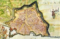 Iraklion at 42.9km (E) The fortified enclosure of the Venetian Chandakas of the 15th century, which is still preserved today, is one of the most significant monuments of its kind in the whole Mediterranean basin. Triangular in shape, with its base at the sea, the mighty enceinte has a perimeter of about 5.5 kilometres. The hallmark of the defensive layout are the bastions, linked by curtain walls decorated at many points by escutcheons and the lion of St. Mark, symbol of Venetian omnipotence. The gates in the enceinte, which served to link the town to the countryside, still stand as important architectural monuments. To this day, the walls that withstood the Ottoman siege in the mid-17th century mark out the boundary of the old town.  Archanes at 43km (E) Anemóspilia (GR: Aνεμόσπηλια). Anemospilia is an archeological site at the northern foot of Mount Yuchtas, in the prefecture of Heraklion in Crete. A rectangular building has been found which dates from the Minoan era and was destroyed by an earthquake in the 17th century BC. The building with three narrow chambers, each opening into a long corridor to the north, which extends along the whole width of the building. The area is enclosed with a stone wall and the whole structure has been interpreted as a shrine; in the central room was found a "xoanon" (statue) of the deity worshiped here. In the west room, where the altar stood, was uncovered, according to the excavator, the first human sacrifice to have ever taken place in Minoan times. (although this view has been challenged). The building at Anemospelia was used for only half a century, as it was suddenly destroyed by an earthquake in the middle of the 17th century B.C. The site was excavated in the summer of 1979 by John Sakellarakis.   Aerial view  Shrine model Links: Minoan Religion (Foundation of the Hellenic World) 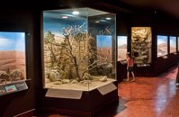 Iraklion, Dermatas Gate at 43.1km (E) The Natural History Museum of Crete is housed in the renovated former premises of the Heraklion Public Power Corporation, on Dermatas’ Bay. With an area of 3,500 m2, it is the largest exhibition of its kind in the Mediterranean, showcasing the natural environment of Crete and the wider Mediterranean area in an innovative, original way. |
||
|
| ||


C
O
N
T
E
N
T
S
O
N
T
E
N
T
S