interkriti®
YOUR GATEWAY TO CRETE
HOME
CRETE FACTS
NAVIGATE
EXPLORE

Agia Galini
Triopetra
Kissamos
Chryssi Isl.
Agia Marina
Balos
Gavdos isl.
Georgioupolis
SAMARIA
IDA Mtn
Palaiochora
Agia Roumeli
Sfakaki
Bali
Kalamaki
Matala
Lassithi
Plateau Lendas
Tsoutsouros
Vianos
Myrtos
Sfakia
Plakias
Ierapetra
Makrygialos
ZAKROS
Vai
Sitia
Agios Nikolaos
Elounda
MALIA
Hersonissos
Gouves
Chania
Rethymnon
Heraklion
GORTYN
FESTOS
KNOSSOS
|
|
Crete
List Grid Map
Found
231
- Showing :
141 - 160
 Knossos Palace at 36.3km (S) The Royal Gaming Board was found here, a kind of board game made of ivory, rock crystal, Egyptian blue, silver and gold, now in Heraklion Museum. To the right of the corridor are the "Royal Pottery Stores", where Kamares pottery of the Old Palace period (1900-1700 B.C.) was uncovered, and to thee left, storage and workshop areas. Image Library
 Archanes at 36.4km (SE) Anemóspilia (GR: Aνεμόσπηλια). Anemospilia is an archeological site at the northern foot of Mount Yuchtas, in the prefecture of Heraklion in Crete. A rectangular building has been found which dates from the Minoan era and was destroyed by an earthquake in the 17th century BC. The building with three narrow chambers, each opening into a long corridor to the north, which extends along the whole width of the building. The area is enclosed with a stone wall and the whole structure has been interpreted as a shrine; in the central room was found a "xoanon" (statue) of the deity worshiped here. In the west room, where the altar stood, was uncovered, according to the excavator, the first human sacrifice to have ever taken place in Minoan times. (although this view has been challenged). The building at Anemospelia was used for only half a century, as it was suddenly destroyed by an earthquake in the middle of the 17th century B.C. The site was excavated in the summer of 1979 by John Sakellarakis.   Aerial view  Shrine model Links: Minoan Religion (Foundation of the Hellenic World)  Messara, Iraklion South at 36.5km (S) Gallia is one of the oldest villages of the area. It is mentioned as a location in the Venetian records as early as 1577, and as a village with 120 residents since 1583. The renaissance tower in the village (still imposing although rundown) and the water fountains in the Kapeloniana area are proof of the passing of the Venetians. Part of the village, called Monohoro, is mentioned as early as 800 A.D.  Kenouriou, Iraklion at 36.5km (SE) Megali Vrissi (GR: Μεγάλη Βρύση) lies 32km south of Heraklion, at 620 m above sea level. In the Barozzi document of 1577, it is mentioned as forming part of the province of Monofatsi and, in the Archives of Megalo Kastro (Heraklion), it is quoted in 1583 as having 71 inhabitants; there is also a reference to the village in the Basilicata document of 1630. The Turkish census records it with 47 families in 1671, and in the Egyptian one in 1834, it figures with 27 families. In the censi of 1881 and 1900 it is mentioned as a municipality in its own right with, respectively, 240 inhabitants and 307 inhabitants. As of 1928, it becomes a commune and today it counts over 900 inhabitants. Saint Constantine is the patron saint of the village. The churches of Aghia Anna and of the Panagia Almiri are worth visiting. The Aeolian Park, one of the islands pioneering projects, has been installed in Megali Vrisi and produces electricity of 5MW.  Voroi, Messara, Iraklion at 36.7km (S) The exhibited objects in the Museum come from all over Crete. These objects show that the folk culture of Crete is characterized by an amalgam of influences in which Minoan (2000-1000 BC), Archaic (1000-500 BC) and Byzantine models prevail, especially in agriculture, stock breeding, pottery and basketry.
 Kenourgiou, Iraklion at 36.9km (SE) Moúlia (GR: Μούλια) is a village in Kenouriou county, located three and a half kilometers away from Agia Varvara town and 32 km from Iraklion at an altitude of 640 m above sea level. Moulia is an old village as we come across a reference to it in a document dated in 1248, where the settlement is recorded as belonging to the archbishopric of Crete. Another reference is found in a legal agreement established in 1411. The name figures in all the Venetian censi of the 16th and 17th centuries, as well as in the Turkish and Egyptian censi. In 1881, it forms part of the municipality of Zaros with about 180 inhabitants, and again in 1900. As of 1920 it is a commune in its own right, and today with the lower village of Kato Moulia it counts over 550 inhabitants. The main church of the village, with wall paintings, is that of the patron saints, Saints Peter and Paul, and there is a village feast on the 29th June, in their honour. The lovely chapel of Zoodochos Pigis is also well worth a visit.
 Messara, Iraklion South at 37km (S) Vori is a beautiful, traditional village of the county of Pirgiotissas in the Messara Valley. It is located 60 km south of Iraklion and in the western part of the Messara Valley. The village stretches in a slope, by the side of a small river. The archaeological site of Phaistos is 2 km to the south and the coast of Messara 4 km to the west.
 Mires, Messara Valley at 37.4km (S) It is located north of Mires close to a small gorge, with springs and covered with trees. There are many churches in the village the most important one being the church of Agios Nikolaos, a domed church dated to the 13th century. The walls of the temple are hand painted with biblical scenes and pictures of saints
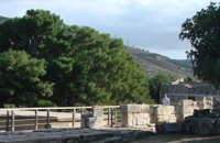
 Archaeological Site in Messara, S-W Iraklion at 37.7km (S) The "Royal Villa" at Ayia Triada which is situated very close to Phaistos, was built in about 1550 BC. i.e. just before the new palace at Phaistos, and was destroyed by fire in l450 BC, like all other important Minoan centres. It succeeded the first palace at Phaistos as the economic and administrative centre of the regions depriving the new palace there of this role, and appears to have had connections with Knossos. The two wings, with an open-air space between them, consisted of groups of interconnecting rooms (polythyra), storerooms and stairways. On the site of the ruins, a Mycenaean megaron, the so-called "Agora" and an open - air shrine were subsequently built. In the villa's disaster layer from the fire in 1450 BC, excavation revealed a valuable group of exceptional works of art, precious materials, records in Minoan script and seals. The famous black serpentine vessels, the "Harvesters' Vase", the "Boxers' Vase" and the "Chieftain ‘ s Cup", the wall paintings depicting the natural landscape, the sarcophagus, the bronze and clay figurines of worshipers and the copper ingots from the Treasury are among the most noteworthy findings.  Kenouriou, Iraklion at 37.9km (SE) Doúli (GR: Δούλι) is a village in Kenouriou county, located 38 km from Iraklion at an altitude of 440 m above sea level. The earliest reference to it, is to be found in the Duke's Archives of 1372, where it is mentioned as the feudal property of Nic. Venerio. The name figures in all the Venetian censi of the 16th and 17th centuries, as well as in the Turkish (1671) and Egyptian (1834) censi. In 1881, Douli forms part of the municipality of Megali Vrisi with about 170 inhabitants, and again in 1900 with only 21 inhabitants. As of 1920, Douli is a commune in its own right, and today Douli has about 240 residents. The patron saint of the village is Aghios Panteleimonas and the feast of the Saint is celebrated on July 27th.A visit to the old church of Aghios Nikolaos is also a must. For those interested in paleontology, there are fossils to be found at the location 'Pirgos'.  Archanes at 38.1km (SE) Excavations at Phourni have brought to light 26 buildings, most of which had funerary use. The cemetery was used from 2400 B.C. until 1200 B.C. and each complex had more than one architectural phase. Most of the funerary buildings were used for many decades and contain successive burials. Excavations were begun in 1964 by Efi and John Sakellarakis and have been continued until today (1995) with short interruptions. Most of the buildings are preserved in good condition.  South Rethymnon at 38.2km (SW) The beach of Agios Pavlos is about 60 km from Rethymno and can be easily reached through an asphalt road. In fact, Agios Pavlos is a small settlement on a beautiful, picturesque cove. Around and close to the beach there are some small hotels and taverns and right on the beach a beautiful cafe / bar. West of the small settlement at a place known as Alatsogremni (Cliffs of salt) are the famous dunes of Agios Pavlos. Although dunes are not rare in the south coast of Crete, those are very impressive. High dunes that end in crystal clear, turquoise waters. A landscape of unique natural beauty that is worth seeing. The scenery is even more imposing late in the afternoon, when the sun is setting and the sand gets a golden hue. It looks like an image coming from another world. Between the small beach at Agios Pavlos and the Dunes we find the area of Apoplystra with the unique rock formations. From the beach of Agios Pavlos climb a wooden staircase and you are in front of a unique spectacle. Rocks sculpted by salt water, in various shapes and wonderful colors.  Iraklion at 38.4km (E) This 2 km long sandy beach was for years and still is the favorite beach of the people of Heraklion town. It is named after the river "Karteros" which outflows at the west end of it near the airport. The water is clean, the seabed is sandy with smoothly shelving and swimming is safe. The access is free in most parts except for some areas that are reserved for military personnel and the municipal beach "Akti" where visitors should pay an entrance fee in order to use the facilities. At the east end there are some very good taverns offering fresh fish among their specialties and are very popular with locals and tourists alike.
Image Library
 Archanes at 38.5km (SE) An excellent specimen of a specialized building, one of the first structures erected during the period of the Cretan State. It was designed by the architect Salivero, one of Prince George's officials. The plans were completed in 1901 and the construction was accomplished thanks to donations of rich Archanians living in the U.S.A. The building is Pi-shaped in plan, has two storeys and a basement, it is built of stone and its roof is partially wooden and covered with tiles. It is a monumental but well balanced structure with many harmonic and elegant Neoclassical features. Since its construction, the building has been used as a school. During the German occupation it housed General Muller's division. Source: The Hellenic Ministry of Culture  Found at Phaistos Palace at 38.6km (S) The disc of Phaistos is the most important example of hieroglyphic inscription from Crete and was discovered around 1903-05 in a small room near the depositories of the "archive chamber", in the north - east apartments of the palace, together with a Linear A tablet and pottery dated to the beginning of the Neo-palatial period (1700- 1600 B.C.). The disc of Phaistos can be seen at the Archaeological Museum of Heraklion. Image Library
 Archane, Iraklion at 38.6km (SE) The Archaeological Museum of Archanes opened in 1993. It occupies an area of 570 square meters and it is located at the Tzami quarter in the center of the settlement. There, for the first time in Crete, the archaeological finds from a single site are exhibited. While the exterior spaces of the building were adapted to a tasteful ensemble, in resemblance with the impressive modesty of the environment and the traditional ochre and rosy colour tonations of Archanes. The interior was thus arranged as to accommodate the most modern mode of exhibition, especially attractive for the visitor. 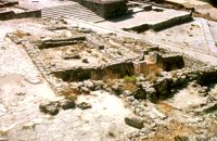 Phaistos Palace at 38.6km (S) The Upper Court is the first of the three courts in the West Wing of the Palace. Its south side is supported by a strong retaining wall separating it from the West Court. On the west side, the 17 circular recesses in the ground indicate the presence of an equal number of wooden columns which probably supported a covered colonnade. The court is crossed from north to south by a raised "Processional Causeway", which, like those of the other palaces, would have been used for sacred processions and other rituals. The Upper Court also functioned as a kind of balcony from which one could watch the events taking place in the West Court, which is just to the south and on a lower level. The two courts are linked by a majestic staircase starting in the southeast part of the Court. The buildings on the south side of the court were built much later, in Hellenistic times (323-67 BC), when the palaces had already beendestroyed. The most important of these contains a room with two columns, a central hearth and stone benches around the walls. It isbelieved to be a public building, probably a Prytaneion or Andreion.Early Christian tombs (330-600 AD) can be seen east of the "Processional Causeway" Image Library
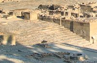 Phaistos Palace at 38.6km (S) The impressive staircase starting in the west Court led to the monumental Propylaea, the principal and most impressive entrance to the New Palace (1700-M50 BC). The portico consists of a central column - only the base is preserved today - flanked by pilasters. There followed a solid wall with a double opening and a colonnade of three columns. The floors of the Propylaea complex were paved with gypsum slabs which gave it a sumptuous appearance. The colonnade opens onto a large open-air light-well through which rainwater drained away. There are two accesses from the Propylaea to different parts of the Palace. The first access, in the hall with the colonnade, led via a staircase and corridors to the Peristyle and thence to the "Royal Apartments". The second, in the SE corner of the light-well, led to an inner staircase which ended in the Antechamber of the Magazines and the Central Court of the Palace. Image Library
North Wing Phaistos Palace at 38.6km (S) The North Wing is one of the most important wings of the Palace, as it is believed to have housed the "Royal Apartments". lt also contained sets of rooms, inner courtyards, corridors and staircases leading to the upper floor. The splendid gateway on the north side of the Central Court led to the complex of the "Royal Apartments". It is framed by two magnificent wooden half-columns, now reconstructed. On either side of the gateway are two niches decorated with wall paintings, in which the gate guards may have stood. Behind the gateway is a wide corridor with a drainage duct, which led to an inner courtyard, which in turn led to the "Royal Apartments" complex. The term "Royal Apartments" was established by the excavators, who followed the terminology applied by Evans to similar areas at Knossos. They are undoubtedly official apartments with particular architectural features, such as open balconies and colonnades, polythyra (pier-and-door partitions), lightwells and "Lustral Basins". The gypsum slab flooring and colourful wall paintings gave these apartments a particularly luxurious appearance. 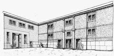 Image Library
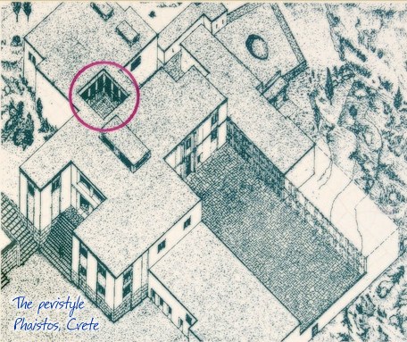
Peristyle
Phaistos Palace at 38.6km (S) The open peristyle court was one of the most elegant inner courtyards of the New Palace. It consisted of an impressive peristyle with four columns on each side supporting the corresponding colonnades, while the central area remained open. The same construction appears to have continued on the upper floor, with a second row of columns. The peristyle court was a focal point of the Palace with access routes leading from here to the "Royal Apartments", the Propylaea and the Central Court. The ruins visible on a lower level in the centre of the peristyle belong to a house of the Prepalatial settlement (3200-1900 BC).
|
|||
|
| |||


)
)
)
)
)
C
O
N
T
E
N
T
S
O
N
T
E
N
T
S