interkriti®
YOUR GATEWAY TO CRETE
HOME
CRETE FACTS
NAVIGATE
EXPLORE

Agia Galini
Triopetra
Kissamos
Chryssi Isl.
Agia Marina
Balos
Gavdos isl.
Georgioupolis
SAMARIA
IDA Mtn
Palaiochora
Agia Roumeli
Sfakaki
Bali
Kalamaki
Matala
Lassithi
Plateau Lendas
Tsoutsouros
Vianos
Myrtos
Sfakia
Plakias
Ierapetra
Makrygialos
ZAKROS
Vai
Sitia
Agios Nikolaos
Elounda
MALIA
Hersonissos
Gouves
Chania
Rethymnon
Heraklion
GORTYN
FESTOS
KNOSSOS
|
|
Crete
: Regional Interest
List Grid Map
Found
284
- Showing :
261 - 280
 Kenourgiou, Iraklion Moúlia (GR: Μούλια) is a village in Kenouriou county, located three and a half kilometers away from Agia Varvara town and 32 km from Iraklion at an altitude of 640 m above sea level. Moulia is an old village as we come across a reference to it in a document dated in 1248, where the settlement is recorded as belonging to the archbishopric of Crete. Another reference is found in a legal agreement established in 1411. The name figures in all the Venetian censi of the 16th and 17th centuries, as well as in the Turkish and Egyptian censi. In 1881, it forms part of the municipality of Zaros with about 180 inhabitants, and again in 1900. As of 1920 it is a commune in its own right, and today with the lower village of Kato Moulia it counts over 550 inhabitants. The main church of the village, with wall paintings, is that of the patron saints, Saints Peter and Paul, and there is a village feast on the 29th June, in their honour. The lovely chapel of Zoodochos Pigis is also well worth a visit.
The area of Plakias Agios Vassilios, Rethymno The villages: Agios Vassilios, Agios Ioannis, Armenoi, Kali Sikia, Kanevos, Selia, Mirthios, Mariou, Asomatos, Atsipades, Koxare, Lefkpgia, Agousseliana. The beaches: Plakias, Damnoni, Ammoudi, Shinaria, Souda, Gavdolimano and the Palm Beach near the monastery of Preveli 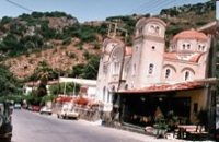 Spili, Rethymno The villages Spili, Agia Galini, Akoumia, Ardaktos, Drimiskos, Karines, Kentrohori, Kerames, Kissos, Krya Vrissi, Lampini, Melampes, Mournes, Mixorouma, Orne, Saktouria The beaches of Agios Pavlos, Triopetra, Drimiskiano Ammoudi  Kissamos The village of Polyrinia is built on the foot of the hill that ancient Polyrinia used to be. It is a small village located 6.5km away from Kastelli Kissamou, built at an altitude of 300 m. and has approximately 100 permanent residents. Its old name was Apano Paleokastro and was renamed to Polyrinia due to its proximity to the archaeological site. Important sights are: the aqueduct of Andrianos, the temple of the Assumption of the Holly-Mother and an old olive mill.
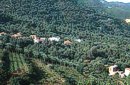 Kissamos, Hania Vlatos is located at 380m a.s.l., 54 km away from Hania and 18 km from Kastelli Kissamou. It is built in a tree covered valley, with olive trees, chestnut trees and wild vegetation. There are some very nice trekking paths around and in the forest of "Peace" which has been characterized as a natural park. The "Park of Peace" was founded in 1970 by the Cultural Association of Vlatos with the cooparation of Goethe Institute and the support of the Bavarian Department of Forests. It is an experimental park with 150 species of plants, covers an area of 1,000,000 sq.m. and is part of an extended area of 20 sq.km. which have been reforested. The area of Mournies Kydonia The villages of Mournies, Souda, Therisso, Drakona, Tsikalaria, Vamvakopoulo, Varipetro, Nerokouros, Perivolia, Plativola...
The Municipality of Nea Kydonia Nea Kydonia Hrissi Akti, Makris Tihos, Agii Apostoloi, Glaros, Daratso, Galatas, Stalos
 Malevizi, North - West Iraklion Ahláda (GR: Αχλάδα) is a small village located 24 kms west of Iraklion at an altitude of 300 meters a.s.l. It is close to the tourist resorts of Agia Pelagia and Ligaria, and it has approximately 500 inhabitants, most of them farmers and stock breeders. The name of the village meaning wild pear tree is given probably due to the huge wild pear tree that used to be at the village. The Cave of Arkalohori Arkalohori It was supported by Spiros Marinatos, that the cave had been a worship centre since 2500 BC, in favour of a war god possibly, as most of the votive were weapons.
The Municipality of Asterousia South Iraklion The mountain range of Asterousia (Eastern part), the beaches, the facilities, the sightseeing and the villages: AGIA FOTIA, AMYGDALOS, APOSELEMI, AHENTRIAS, VORIAS, DORAKI, ETHIA, KALIVIA, KEFALADO, LIGORTINOS, MADES, MESOHORIO, MOURNIA, NEOHORI, PARANIFI, PLAKIOTISA, PRINIAS, PROTORIA, PIRATHI, PIRGOS, ROTASI, TEFELI, HARAKAS, HARAKI, TREIS EKLISIES, PERA TSOUTSOUROS, MARIDAKI, AGIOS NIKITAS MONASTERY... The Municipality of Kofinas The municipality of Kofina covers an area of great natural beauty that will enchant all visitors. The villages Asimi, Akria, Atsipades, Morias, Kasteli (Tsifout), Loures, Dionysi, Panaghia, Sternes, Stoloi, Inia, Sokaras, Apoini, Stavies, Fournofarango, Kapetaniana, the monastery of KOUDOUMAS...
The village of Vrahassi Vrahassi Vrahasi is an old Cretan village, built amphitheatrically at the slope of the mountain Anavlohos (alt. 625m) with an excellent view towards the Lasithiotika mountains and the gorge of Selinari.
The Municipality of Gorgolaini Agios Myron The villages:Agios Myron, Ano Asites, Kato Asites, Pentamodi, Petrokefalo and Pyrgou. The historical monastery of Gorgolaini. Electricity in Crete Voltage :220 - 240V,Frequency: 50 Hz, Sockets/Outlets: 2 pin + earth/ground "Shuko" or 2 pin (round) lighting type. 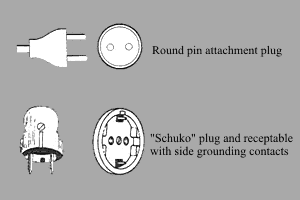
 Gonia, Rethymno The Municipality of Nikiforos Fokas is located in the north of Rethymnon Prefecture. The area is known for its outstanding natural beauty and its historical tradition and architecture. All of the municipality's settlements are steeped in history and contain fine examples of architecture, featuring stone buildings with vaulted entrances (known as "diavatika") and magnificent thresholds. The municipality's jurisdiction extends over the fourteen former community wards of Agios Konstantinos, Ano Valsamonero, Atsipopoulo, Gerani, Gonia (Athanatos), Zouridi, Kalonyktis, Kato Valsamonero, Malaki, Mountros, Prines, Roustika, Saitoures and Frantzeskiana Metochia, which comprise a total of 21 villages.  Amari, Rethymnon The village of Apodoulou is located 55 km from Rethimno at an altitude of 450m. Remains of an extensive centre of the Old Palace period (1950-1700 B.C.) have been uncovered.at the site called Gournes, near the village of Apodoulou, at the west foot of Psiloreitis. The site dominates the Amari valley and controls the main route to the Messara plain. Excavations have brought to light three building complexes while tholos tombs of the Postpalatial period (1380-1200 B.C.) have also been located in the adjacent area. The first excavations on the site were carried out by S. Marinatos in the 1930's. During World War II it was excavated by the German Archaeological Institute, under the direction of E. Kirsten. Since 1985, systematic excavations have been carried out by the Greek Ministry of Culture in collaboration with the University of Naples. The most important monuments on the site are: Building A. It lies on the east side of the hill, to the south of the massive retaining wall. It had two storeys, as is indicated by the two preserved steps of a staircase. Decades of pithoi and other vases found on the ground floor suggest that it was used for storage. The house was destroyed by fire which followed an earthquake. Building B, located to the north of the retaining wall. It is a complex of rooms which originally communicated with Building A. Building C. It lies to the east of house A and belongs to a later phase of the settlement. Tholos tomb at Sopatakia. Tholos tomb with dromos, lying to the east of the road that leads from Apodoulou to Nithavris. The dromos is 7 m. long and the chamber has a diameter of 3.10 m. Three larnakes were found inside the burial chamber. Dated to 1380-1200 B.C. Source: The Hellenic Ministry of Culture  Archanes, Iraklion A small traditional town (~4000 people) 15 km south of Iraklion on the foot of the sacred mountain Yiouhtas. Renowned for its excellent wine (from the varieties: vilana, kotsifali and madilari) and the archaeolocical sites and caves. In 1912, Xanthoudides noted the importance of Archanes, but Sir Arthur Evans was the first to characterize the site as palatial, declaring that Archanes was likely a Summer Palace for the Knossos kings. Spyridon Marinatos and N. Platon excavated minor areas in the region, but nothing supported Evans' theory. In 1964, J. Sakellarakis dug trial trenches at the Tourkoyeitonia site and uncovered the first evidence of a palace site. Since 1966, Archanes has been excavated by the Greek Archaeaological Society under the supervision of John Sakellarakis and Efi Sapouna-Sakellarakis. The small town of Epano Archanes, one of the most famous places of the Cretan land, with its colorful courtyards, teaches culture, taste, tradition, colors, aromas and life itself. The silvery grays of the olive groves, the red, pink, salmon and tiled walls, the blue and green shutters, the colorful bougainvillea boldly climbing the walls of the houses, the manicured flower beds, but also the elaborate, colorful signs in coffee shops and grocery stores. All this makes Archanes the most colorful village of Crete, but also of Greece. The town is full of atmospheric neighborhoods with well-maintained houses, painted in cheerful colors. At each step the visitor learns more and more about it. That's why the locals have taken care of it: the Folklore Museum, the Archaeological Museum, the sculpture workshop, the Museum of Cretan History and Tradition just outside. Image Library
|
||
|
| ||


)
C
O
N
T
E
N
T
S
O
N
T
E
N
T
S