interkriti®
YOUR GATEWAY TO CRETE
HOME
CRETE FACTS
NAVIGATE
EXPLORE

Agia Galini
Triopetra
Kissamos
Chryssi Isl.
Agia Marina
Balos
Gavdos isl.
Georgioupolis
SAMARIA
IDA Mtn
Palaiochora
Agia Roumeli
Sfakaki
Bali
Kalamaki
Matala
Lassithi
Plateau Lendas
Tsoutsouros
Vianos
Myrtos
Sfakia
Plakias
Ierapetra
Makrygialos
ZAKROS
Vai
Sitia
Agios Nikolaos
Elounda
MALIA
Hersonissos
Gouves
Chania
Rethymnon
Heraklion
GORTYN
FESTOS
KNOSSOS
|
|
Crete
List Grid Map
Found
158
- Showing :
141 - 158
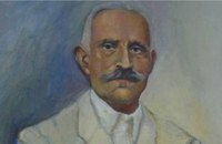 born in Viannos at 24.1km (SE) Author and journalist(1862-1920). He was born in the village Ano Viannos in 1862. In his childhood he moved with his family in Piraeus. Quite soon though, only 3 years later, they got back at their special homeland and there, he finished the elementary school. Though he'd started attending high school in Iraklion, he finished it in Varvakeio School, in Athens. His first novel was published in the newspaper 'Estia', in 1884. He was enrolled in the Philosophy School, but he never graduated. In 1885 he got back in Crete, where he took a job as a teacher in Modi, Kydonias. His revolutionary character motivated him into writing patriotic articles in the local paper, an act that infuriated the Turkish occupants to such an extent that he had to flee in Athens, only this time he stayed permanently. In Athens he worked for several newspapers like 'Estia', 'Asty' and 'Embros'. For more than 20 years he kept writing chronicles, which helped him win respect among the intellectuals. He used to use the pseudonym 'Diavatis' (Passer-by). During his long literary career he wrote: 'Gramvoussa, i epanastasis en Kriti' (Gramvoussa, the revolution in Crete), 'I olokaftossis tou Arkadiou' (The Holocaust of Arkadi), 'Otan imoun daskalos' (When I was a teacher), 'Proti Agapi' (First Love), 'Eno diavaina' (When I was passing by), 'O Patouchas', 'Zampeliou Kai Kritovoulidou, Istoria Kritikon Epanastaseon' (Zampeliou and Kritovoulidou, Cretan Revolutions History), 'Imere kindynon kai fovou' (Days in danger and terror). Kondylakis’ entire work is collected in his 'Apanta' (Collected works).Ioannis Kondylakis died in Irakleion, in 1920.  Kenourgiou, Iraklion at 24.3km (W) Priniás (GR: Πρινιάς) is a small village located 35km southwest of Iraklion town and 4km from Agia Varvara, at a height of 610 m above sea level. The village of Prinias lies on the border of three regions: Malevizi, Kenouriou and Monofatsi, and is recorded as forming part of all three regions in the censi.  Kenourgiou, Iraklion at 24.4km (SW) Agia Varvára (GR: Αγία Βαρβάρα) is a town built along the road between the Messara plain and the Malevizi region at the highest point (580 m). The town enjoys a unique location with a splendid view into the Malevizi region, and a cool climate, particularly pleasant during the hot summer months. It produces first-rate fruit and vegetables. Because of its strategic location on the main north-south axis, the town was often exposed to fierce battles. A famous warrior, Mathiou Kapitakis or Mathioudakis was born here: he fought side to side with Karaiskakis and was killed at Faliro. His comrade-in-arms, Logios, was the hero of Aghios Thomas. As you reach the village, on the north side there is a rock with a chapel dedicated to Profitis Ilias. On this rock -which used to be twice as large but part of it fell off at the beginning of the 19th century- there used to be an ancient temple. Nowadays, the visitor can find every kind of commodity and facility on hand at the modern town of Aghia Varvara. In summer a special 'tsikoudia' feast, and in early spring a carnival feast are organized by the Cultural Association of the town. At the centre of the town, there are two churches - one old and one new - both dedicated to the patron saint, Aghia Varvara. Three Byzantine churches are also well worth a visit: Profitis Ilias, Aghios Giorgos and Aghios Ioannis, and of course the old monastery of Aghia Pelagia by the cemetery.  Iraklion north at 24.5km (N) Dia (GR: Δία & Ντία) is an uninhabited island approximately 7 nautical miles north of Heraklion. It is surrounded by small rocky inlets and its maximum length is 5kms while its maximum width 3kms. Dia is one of NATURA's protected areas due to its status as a biotope for endemic plants and for plants with low dispersal within the Southern Aegean. Image Library
 East Ida mountain, Iraklion at 25.8km (W) Prinos refuge at Prinos on Psiloritis mountain (Ida), is at 1100 metres. It can sleep 25 people, it has cooking facilities, two wood burning stoves for heating and a rainwater tank. Access is through the village of Ano Assites in Malevizi around 22km from Iraklion. From there a two kilometres of dirt road leads to a place called Melisses and then a one-and-a-half hour walk along a footpath signed with red marks, to the refuge. Prinos hut was built in 1962 and was renovated around 1992. It is run by the mountaineering club of Heraklion. The view from Prinos to the north and east is great.   Mirabello, Lassithi at 26.1km (E) The village of Sissi, a picturesque village 40 km east of Heraklion and 25 km west of Ag. Nikolaos. Sissi is a beautiful fishing village with strange nature. On one side of the village the nature is wild, with a small river flowing into the sea, a number of palm trees on its banks, ducks and geese swimming peacefully. On the other side there are sandy and gravel beaches, caverns in the rocks and deep clear water, full of many kinds of fish. A place that gathers the nature of different places of Crete.
 Kenourgiou, Iraklion at 26.3km (SW) Moúlia (GR: Μούλια) is a village in Kenouriou county, located three and a half kilometers away from Agia Varvara town and 32 km from Iraklion at an altitude of 640 m above sea level. Moulia is an old village as we come across a reference to it in a document dated in 1248, where the settlement is recorded as belonging to the archbishopric of Crete. Another reference is found in a legal agreement established in 1411. The name figures in all the Venetian censi of the 16th and 17th centuries, as well as in the Turkish and Egyptian censi. In 1881, it forms part of the municipality of Zaros with about 180 inhabitants, and again in 1900. As of 1920 it is a commune in its own right, and today with the lower village of Kato Moulia it counts over 550 inhabitants. The main church of the village, with wall paintings, is that of the patron saints, Saints Peter and Paul, and there is a village feast on the 29th June, in their honour. The lovely chapel of Zoodochos Pigis is also well worth a visit.
Petra & Fos pizzeria - cafe bar Tsoutsouros at 27km (S) Delicious pizza in the wood heated oven, wonderful surroundings, ice cold beer, just by the libyan sea.
 Krassas, Tsoutsouros at 27.1km (S) Palm House is a beautiful stone-built house on the south coast of Ceete. It is built on a tree-lined plot with panoramic sea views ,ideal for comfortable accommodation for 4 people. Its distance from the sea is only 300 meters.
 Monofatsi, South Iraklion at 27.1km (S) Tsoutsouros (GR: Τσούτσουρος) is a small village on the southern coast of Iraklion prefecture, with lovely beaches and a small harbour. The ancient city of Inatos, used to stand were Tsoutsouros is now. Inatos served as a port to Priansos a renowned city - state of the Hellenistic time, located near the village of Kasteliana. Tsoutsouros is a popular tourist resort especially with Greek families. There are many taverns and cafes most of them around the small harbour, and a good choice of apartments and hotels along the beach. Image Library
 Mirabello, Lassithi at 27.2km (E) At the side of the gorge of Selinari, at the 42 km. of the national road Iraklion - Agios Nikolaos is the small old chapel and the newly founded monastery of Agios Georgios Selinaris. In the monastery there is also a home for the aged founded in 1963. The small chapel was probably founded early in the 16th century AD, and ever since it is a place of worshiping. The people passing through the chapel stop to light a candle to the saint. The chapel is considered miraculous, there are various legends concerning miracles related either with healing of sick people or with divine punishment of people that did not pay the respect due to the saint.
 Krasas, Tsoutsouros at 27.4km (S) Seaside Houses located an hour drive (60kms) from Heraklion's airport at Tsoutsouros village. The houses are on the top of a headland separating two bays with magnificent beaches - the one almost private! - constituting a majestic scenery of virgin Crete with both sea and mountain view. Unique place for those who seek privacy, peace and romantic mood. The houses are fully equipped and have large shaded verandas. Prices from € 160/ night (2people)  Selinari, Vrahassi at 27.5km (E) Near the beautiful village of Vrahasi there is the imposing gorge of Selinari, formed by the mountain of Anavlohos (625 m) to the north and the mountain Fonias o Detis (818 m) to the south. The symbol of Crete, the Cretan wild goat (Agrimi or kri-kri) and the Griffon Vulture are two rare species that used to reside in the gorge. The authorities in Vrahasi intend to establish a center of protection of the local fauna and flora at the gorge of Selinari and to develop a wildlife station, to provide observation of the Griffon Vulture colony at the east side of the gorge of Selinari. The hunting is forbidden in an area covering 10 sq.km. around the gorge.  Agia Pelagia, Maleviziou, Iraklion N-W at 27.6km (NW) Lygaria (also Ligaria GR: Λυγαριά) is a small seaside resort 2 kms to the east of Agia Pelagia. It is built in a small cove with a lovely sandy beach protected from the summer winds (Meltemi). Lygaria started as a residential area comprising of summer houses built mainly by residents of Heraklion but soon it has developed to a tourist resort. It has a couple of small taverns, hotels and cafes by the beach and it is very popular with tourists and locals alike. There is regular public bus transport from Heraklion. The distance from Heraklion is 19 kilometers via the national road.
Image Library
 Monofatsi, South Iraklion at 27.9km (S) Maridaki (GR: Μαριδάκι) is a small coastal hamlet in the bay of Tsoutsouros on the southern coast of Iraklion prefecture. It is built at the end of the gorge of Ahendrias.
Image Library
 Malevizi, Iraklion at 28.3km (NW) Dóxa (GR: Δόξα) is a pretty village built on a height of 400 metres above sea-level and 20 kilometres to the west of Heraklion on the road to the mountainous Milopotamos. The historical cave of Dóxa (GR: Δόξα) is located in a short distance from the village of Marathos on the road to Heraklion. It is at a height of 490 metres above sea-level, near a well-known taverna also called DOXA. The cave has a total length of 50 metres and impressive stalactites and stalagmites.  Malevizi, North - West Iraklion at 28.8km (NW) Agia Pelagia lies 20km west of Iraklion. The bay of Agia Pelagia is ideal for combining sea sports with relaxation. The visitor will find well trained instructors that offer lessons for sea sports such as water-ski, wind surf, canoe. Agia Pelagia offers unique high standard hotel facilities as well as many small hotels and pensions.
 Malevizi, North - West Iraklion at 29.8km (NW) Ahláda (GR: Αχλάδα) is a small village located 24 kms west of Iraklion at an altitude of 300 meters a.s.l. It is close to the tourist resorts of Agia Pelagia and Ligaria, and it has approximately 500 inhabitants, most of them farmers and stock breeders. The name of the village meaning wild pear tree is given probably due to the huge wild pear tree that used to be at the village. |
||
|
| ||

)
C
O
N
T
E
N
T
S
O
N
T
E
N
T
S