interkriti®
YOUR GATEWAY TO CRETE
HOME
CRETE FACTS
NAVIGATE
EXPLORE

Agia Galini
Triopetra
Kissamos
Chryssi Isl.
Agia Marina
Balos
Gavdos isl.
Georgioupolis
SAMARIA
IDA Mtn
Palaiochora
Agia Roumeli
Sfakaki
Bali
Kalamaki
Matala
Lassithi
Plateau Lendas
Tsoutsouros
Vianos
Myrtos
Sfakia
Plakias
Ierapetra
Makrygialos
ZAKROS
Vai
Sitia
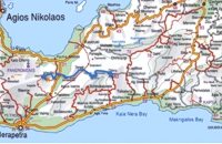
Agios Nikolaos
Elounda
MALIA
Hersonissos
Gouves
Chania
Rethymnon
Heraklion
GORTYN
FESTOS
KNOSSOS
|
|
Crete
List Grid Map
Found
59
- Showing :
21 - 40
 Mirabello, Lasstithi at 11.6km (N) Lato (Gr: Λατώ) was an ancient city of Crete, the ruins of which are located approximately 3 km from the small town of Kritsa. The Dorian city-state was built in a defensible position overlooking Mirabello Bay between two peaks, both of which became acropolises to the city. Although the city probably predates the arrival of the Dorians, the ruins date mainly from the Dorian period (fifth and fourth centuries BC). The city was destroyed ca. 200 BCE, but its port (Lato Etera or Lato pros Kamara), located near Agios Nikolaos was in use during Roman rule. There is some suggestion that the city was named after the goddess Leto (of which Lato is the usual Doric form) and may be mentioned in Linear B tablets as RA-TO. Lato also minted coins in antiquity,[3] bearing the likeness of the goddess Eileithyia who appears to have been the one particularly worshipped at Lato. Nearchus, admiral of Alexander the Great, was born at Lato.  Pahia Ammos, Ierapetra at 12.9km (E) Gournia lies on a small hill, a few hundred metres from the sea in the Gulf of Mirabello, close to the north end of the Ierapetra isthmus ( 2 Km from Pachia Ammos village & 19 Km from Ag.Nikolaos). Gournia - the ancient name of which is not known - is the most characteristic of the excavated medium-size settlements, dated to the period of the peak of the Minoan culture (Late Minoan I period: 1550-1450 B.C.). It is called "Pompeii of Minoan Crete" because of the good state of preservation. It occupies a low hill, close to the sea, at the Isthmus of Ierapetra. Vassiliki - Archaeological Site Pahia Ammos, Ierapetra at 13.5km (E) The ancient settlement of Vasilike is one of the first Minoan settlements with town-planning. It occupies the top and slopes of a low hill near the village Vasilike, in the vicinity of the Minoan settlement of Gournia. The first settlement dates back to the Early Minoan II period (2600-2300 B.C.) and owed its development not only to the strategic position, controlling the Isthmus of Hierapetra, but also to the neighbouring fertile plains. The central building of the settlement was destroyed by fire in around 2300 B.C. 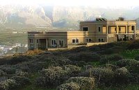 Pachia Ammos at 13.6km (E) The Institute for Aegean Prehistory Study Center for East Crete (or INSTAP-SCEC) is a unique facility for archaeological research, especially in the area of Aegean Prehistory. The Center is committed to stimulating and facilitating publication in the broader field of Cretan studies, with a focus on archaeology and ethnology.
 Agios Nikolaos, Lassithi at 13.7km (NE) Well protected Marina by all weather condition, build to European standards and capable to accommodating up to 255 boats all year round. The Marina of Aghios Nikolaos is located in the heart of the town, provides all the necessary facilities for a pleasant short or long stay for yacht passengers and a safe environment for the boats. Facilities: Water/Electricity:Each berth has access to a service box where fresh water and 220 / 380 volt electricity available.  North East Crete, Lassithi at 14.1km (NE) Agios Nikólaos (GR: Αγιος Νικόλαος), with 9.500 inhabitants, is the capital of the Lassithi province of Crete. It is built around a picturesque lake at the north-western side of the Mirabello bay, the biggest bay in Crete. Major administrative, cultural and communications center, Agios Nikolaos is one of the most developed tourist areas, not only in Crete but in Greece in general. Thanks to the beautiful coasts, the great sights and the cosmopolitan life, this lively city hosts every year thousands of visitors without losing one bit of its tranquility and traditional hospitality.
Image Library
 Agios Nikolaos, Lassithi at 14.1km (NE) Lake Voulismeni (Gr: Λίμνη Βουλισμένη) or just "the Lake" for the locals, is located at the centre of the town of Agios Nikolaos. It has a circular shape of a diameter of 137 m and depth 64 m. The lake connects to the harbour of the town by a channel dug in 1870. A panoramic view of the lake can be seen from a small park situated above it. According to legend, the goddess Athena bathed in it. Every year at midnight turning to Orthodox Christian Easter day, the majority of the population of the town gathers around the lake to celebrate with fireworks, and firecrackers. It was reported that the German army during their withdrawal from the area at WW2, disposed parts of their weaponry and/or vehicles into the deep lake. A local urban legend has it that the lake is bottomless. That notion is potentially based on its impressively disproportional high depth compared to its width (64m depth on only 134m width) or/and on locals noticing disturbances at the surface or also the level of the water during the Santorini (Thera) earthquake of 1956. Because of the latter, many assume a possible geological relation of the two locations, but this claim has not been substantiated by known scientific surveys to date. Image Library
 Agios Nikolaos, Lassithi at 14.2km (NE) The Folk Art Museum of Aghios Nikolaos, in collaboration with the "Cultural Society of Eastern Crete", founded in 1978. All the original and important material was generously offered by the Touring Club of Aghios Nikolaos. Since then more objects have been added to the collection. A visit to the Folk Art Museum will help you to become familiar with the sort of work and activities the people of this area had in the old days. The Museum houses a rich and beautiful collection of hundreds of genuine samples of Cretan popular art and mainly hand woven and embroidered pieces, some of which are unique.  Agios Nikolaos, Lassithi at 14.3km (N) The Archaeological Museum of Aghios Nikolaos is one of the most important in Crete and has been in operation since 1969. It houses collections of very important archaeological finds from the whole of Eastern Crete, an area extending from Malia as far as Zakros. These are displayed in chronological order from the Neolithic period (5700 - 2800 B.C.) to the end of the Roman times (100 B.C. - 400 A.D.) Its showcases include more than 1350 vases from the 3rd millennium B.C. as well as gold and copper finds (the most ancient found in Crete).
 Agios Nikolaos, Lassithi at 14.3km (N) Agios Nikolaos General Hospital (GR: Γενικό Νοσοκομείο Αγίου Νικολάου) is located in Agios Nikolaos in the prefecture of Lassithi. The St. Nicholas Hospital is a large modern hospital that provides full medical treatment and services to the population of the area since 1940.  by Richard Ellis at 18.9km (NW) This was another delightful start to a day’s walking. Rather than tramping round the perimeter which is more or less where the E4 is supposed to go, it is quite possible to take a diagonal line from the south east corner to the north west corner by taking a right, then a left, then a right etc so you end up close to Kato Metochi. This way, you get to see close up the extent of the agricultural activity going on around the plateau in the morning sunshine. You also get to see the newly formed baby frogs – fresh from tadpole status – hopping happily in the sunshine in front of my big boots. Distance: 23.5 km Time: 7 hrs. Mov av 4.7 km/hr Height overnight: 335m.(max 824m.)  Lassithi, Dikti Mountains at 19.5km (NW) The Lassithi Plateau (GR: Οροπέδιο Λασιθίου, Oropedio Lasithiou), is a high endorheic plateau, located in eastern Crete, Greece on the mountain range of Dikti at an average altitude of 840 m, and in a distance of around 55km from Heraklion and 50km from Agios Nikolaos. The plateau is elliptical in shape with an E-W axis of 11km and the N-S of 7km. The plateau of Lassithi is renowned for its exceptional agricultural produce, the thousands (almost 15000) windmills that used to be there in the past, its significant historical role and for the unique cave of Psychro also known as "Diktaion Andron". Image Library
 Mirabello, Lassithi at 20.7km (N) Neapolis is located 15 km westwards of Agios Nikolaos on the way to Heraklion from where it is roughly 50 km far. Neapolis is built in the green valley of Mirabello. In the period of the Venetian domination its two settlements were named "New Village". But when the seat of the Prefecture was transferred from Fourni to the “New Village” this last was renamed to Neapolis. Neapolis was maintained as the capital of the prefecture of Lasithi till 1904. After that date Agios Nikolaos became the new capital.  Psychro, Lassithi Plateau at 21.6km (NW) The cave of Psychro is one of the most important cult places of Minoan Crete. The excavators and several scholars identify the cave as the famous "Diktaian Cave", where Zeus was born and brought up with the aid of Amaltheia and the Kouretes, and which is connected with myths as this of the seer Epimenides who "slept" here, or the coupling of Zeus with Europa.
 Mirabello Bay, Lassithi at 21.7km (N) The area is touristic developed with many shops, restaurants on the shore, bars and several excellent hotels famous for their comforts and the variety of amenities offered. The lagoon of Elounda is shaped between the coast and a small peninsula of 7-8 km length ... Spinalonga, since antiquity, has protected the harbor of ancient Olous.
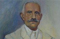 born in Viannos at 22.6km (W) Author and journalist(1862-1920). He was born in the village Ano Viannos in 1862. In his childhood he moved with his family in Piraeus. Quite soon though, only 3 years later, they got back at their special homeland and there, he finished the elementary school. Though he'd started attending high school in Iraklion, he finished it in Varvakeio School, in Athens. His first novel was published in the newspaper 'Estia', in 1884. He was enrolled in the Philosophy School, but he never graduated. In 1885 he got back in Crete, where he took a job as a teacher in Modi, Kydonias. His revolutionary character motivated him into writing patriotic articles in the local paper, an act that infuriated the Turkish occupants to such an extent that he had to flee in Athens, only this time he stayed permanently. In Athens he worked for several newspapers like 'Estia', 'Asty' and 'Embros'. For more than 20 years he kept writing chronicles, which helped him win respect among the intellectuals. He used to use the pseudonym 'Diavatis' (Passer-by). During his long literary career he wrote: 'Gramvoussa, i epanastasis en Kriti' (Gramvoussa, the revolution in Crete), 'I olokaftossis tou Arkadiou' (The Holocaust of Arkadi), 'Otan imoun daskalos' (When I was a teacher), 'Proti Agapi' (First Love), 'Eno diavaina' (When I was passing by), 'O Patouchas', 'Zampeliou Kai Kritovoulidou, Istoria Kritikon Epanastaseon' (Zampeliou and Kritovoulidou, Cretan Revolutions History), 'Imere kindynon kai fovou' (Days in danger and terror). Kondylakis’ entire work is collected in his 'Apanta' (Collected works).Ioannis Kondylakis died in Irakleion, in 1920.  South east Iraklion at 22.7km (W) Historical place with outstanding natural beauty, unspoiled villages and great beaches. The town of Ano Viannos is built amphitheatrically on the southern slopes of Dikti mountain at 560 m. above sea in a distance of 65km from Iraklion and 40km from Ierapetra. It preserves the traditional character with the narrow paved streets, the stone built houses - especially the "Plaka' quarter - the old kefeneios with tables under the plane trees and old churches such as Agios Georgios and Agia Pelagia with wall paintings dating back to the 14th century. There are a few accommodation facilities, banks, medical center, taverns, gas stations, shops etc. Ano Viannos is the seat of the municipality of Viannos.
 Ierapetra at 22.8km (S) A picturesque uninhabited small island of cedar forest, tempting golden beaches and the well preserved old church of Agios Nikolaos, only 8 miles off the port of Ierapetra, to the south. From the middle of May to the end of October, there are daily boat cruises to Chrissi island, departing from Ierapetra and Makrygialos. There is a bar restaurant at the south beach and a beach bar at the northern beach also known as "Golden Beach". The island belongs to the NATURA network due to its rare combination of ecosystems which form the habitats of several endemic species.
Image Library
 Richard Ellis walk: Day 4 at 23.3km (E) June 4th - There now followed two 30-plus kilometer days aggravated by the fact that I wanted to summit each range that I passed through - even though there is no strict E4 requirement to do this. So, I set off from Orino by 7.00 am on the clearly marked dirt road which is the pass through the mountains towards the village of Thripti. Distance:32.2 km Time: 11.5 hrs. Mov av 4.2 km/hr Height overnight: 330m.(max 1,476m.)  Seli Ampelou, Lassithi Plateau at 23.4km (NW) It is the most significant group of windmills preserved on Crete. It occupies the northern entrance to the Lasithi plateau and is the landmark of the whole area. Today 24 windmills are preserved (out of the original 26), 7 of which extend to the south of the road that enters the plateau while the rest are built to the north of it. All the mills belong to the one-sided type of windmill, that grinds in a standard position, always on the same direction of the wind. Windmills of this type are preserved on Crete and on Carpathos but the Cretan ones are generally more carefully built and more elegant. The group of windmills has been declared a work of art since 1986. The mills belong to individuals and some of them have been restored while others still remain half-ruined. Source: The Hellenic Ministry of Culture |

|
|
|
| ||
C
O
N
T
E
N
T
S
O
N
T
E
N
T
S