interkriti®
YOUR GATEWAY TO CRETE
HOME
CRETE FACTS
NAVIGATE
EXPLORE

Agia Galini
Triopetra
Kissamos
Chryssi Isl.
Agia Marina
Balos
Gavdos isl.
Georgioupolis
SAMARIA
IDA Mtn
Palaiochora
Agia Roumeli
Sfakaki
Bali
Kalamaki
Matala
Lassithi
Plateau Lendas
Tsoutsouros
Vianos
Myrtos
Sfakia
Plakias
Ierapetra
Makrygialos
ZAKROS
Vai
Sitia
Agios Nikolaos
Elounda
MALIA
Hersonissos
Gouves
Chania
Rethymnon
Heraklion
GORTYN
FESTOS
KNOSSOS
|
|
Crete
: Regional Interest
List Grid Map
Found
65
- Showing :
21 - 40
 Apokoronas, Hania at 31km (SE) Crete's only freshwater lake, Lake Kournás (GR: Λίμνη Κουρνά), is relatively large, with a perimeter of 3.5 km. Although almost all touristic leaflets say that it is possible to walk around the lake, that is not true. At least not at the end of the rain season (winter). There is a nature preserve on the Southwest of the lake. But there is a rustic road from the North of the lake to the Hills on the West of the lake too. Image Library
 Lefka Ori, Hania at 31.3km (SW) Kallérgi Mountain Refuge is located on the western region of Crete, above the plateau of Omalos, in the White Mountains (Lefka Ori) mountain range at an altitude of 1680 metres. The site is of unique natural beauty and commands great views to the surrounding peaks and the gorge of Samaria. It can be accessed by car or on foot (1 1/2 hour) via the 5km long dirt road from Omalos. The refuge can accommodate up to 50 people. It features a fully equipped kitchen, a lodge with fire place and wood burning stoves, toilets (indoors and outdoors) and a camping area. Electricity is supplied by a generator. Kalergi refuge operates throughout the year (from November to March only on weekends) For more information please visit:Mountaineering Club of Hania  White Mountains, Hania at 31.7km (SW) The famous - mainly due to the gorge of Samaria- plateau of Omalos (GR: Ομαλός) is surrounded by the high crowns of the Lefka Ori (White Mountains) at 1,040 to 1,250 meters and is just 38 km from the town of Chania. It extends to the counties of Sfakia, Selino and Kydonia in the prefecture of Hania. Its shape is nearly rectangular with a perimeter of about 25kms and a diameter of approximately 4 kms. It can be reached by car from the north (Neratzoporo) and from the south (Agios Theodoros).
 Sfakia, White Mountains at 31.9km (S) It is located at an altitude of 750 m, 50 km SE from the city of Hania and 20 km from the village of Vryses. Its population is approximately 500 people. The small villages that constitute the community of Askifou are Kares, Ammoudari, Goni and Petres. The most touristic organised of them is Ammoudari with restaurants, gas station, and some rooms for rent.
 Sfakia, South Hania at 32.2km (SW) The Samaria Gorge is one of the longest ravines in Europe (with a total length of 16 km) and offers one of the most spectacular hiking routes in Europe. Its width ranges from 150 m (widest part) to 3 m (narrowest part). The walk from Xyloskalo in the plateau of Omalos to the shores of Libyan sea at Agia Roumeli, takes 6 to 8 hours. The Samaria Gorge has been designated as a national park in order to protect its flora and fauna. It is one of the last shelters of the mountain goat of Crete (Cretan Ibex, common name : kri-kri). The flora is extensive, ranging from high cypress trees to flowers and herbs. The walking path follows the river which flows to small lakes and waterfalls. The Gorge is open to visitors from May to October. Image Library
 Omalos, Hania at 33.1km (SW) Xylóskalo (Ksyloskalo GR: Ξυλόσκαλο) is the point where the Samarian gorge starts. It is located on the Lefka Ori (White Mountains) in the plateau of Omalos, 43 km from the city of Hania at 1250m above sea level. It is also the entrance to the gorge. There are two tourist lodges where visitors can rest and have food or coffee and take panoramic pictures of the gorge and the White Mountains. There is also the information center of the National Park and a parking area. Xyloskalo means the "wooden stair" and refers to a wooden staircase built by the locals in order to facilitate the entrance to the gorge as at this point the cliffs are very steep. Today this part of the path is made of stones and it has a wooden handrail. About 1km before Xyloskalo a dirt road leads, after 5 km, to the Kallergis mountain lodge at 1680m a.s.l.  Rethymnon North at 34.5km (SE) Episkopi is a small town of the prefecture and county of Rethymno. It is located at the old national road of Rethymno - Hania, 17 km away from the city of Rethymno. The town is built at 120 m a.s.l. overlooking the northern coast of Crete, and the green and fertile valley of Mousselas river.
 Sfakia, South Hania at 36km (S) The ravine begins from the last houses of the village of Imbros and 8 km after it ends at the village of Komitades. Its crossing is smooth and entails no danger...
 Rethymnon North at 38.5km (SE) A beautiful small town in the county of Rethymno with great views, natural water springs and lush vegetation. It's located at 260m a.s.l. between the rivers "Mousselas" and "Petres", 22km from the national road and 5km from Episkopi. Argiroupolis is the site of the ancient city of Lapa.
 Sfakia, South Hania at 38.7km (SE) Kalikratis is a small mountainous village at the foot of the White Mountains (Lefka Ori) at an altitude of 750m above sea level. It is a traditional village with many well preserved stone houses. A German army of two thousand soldiers, invaded the village during the October of 1943 , burned it down and executed twenty men and nine women who did not manage to leave on time. A little to the south of the village starts the gorge of the same name which is part of the European hiking footpath (E4) and after some 4km walking ends at the village of Patsianos.  Rethymnon at 38.7km (SE) Zouridi is a village of the county of Rethymno, located 19,5 km away from the city, built at 260m a.s.l. with 90 inhabitants. Here excavations unearthed findings from the post palace period, and the Roman period as well as many venetian houses. Nowadays the village is characterized as a preservable settlement, and buildings such as the old high school are going to be restored.
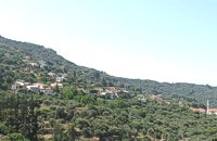
 Sfakia, South Hania at 39.1km (S) Anopolis is a small village, built on a small but fertile plateau, 12 km west from Sfakia at 600 m above sea level. There are still traces of the ruins of the ancient city that prospered around the 3rd century BC, who's port was Phoenix (Loutro). Ancient Anopolis was one of the thirty city - states that signed the peace decree with Eumenes B’ in 183 BC. and thus was able to mint its own coins. During both the Venetian and the Turkish occupations, Anopolis was a center for revolutionary activities. It is the birth place of the freedom fighter Ioannis Daskalogiannis who's statue stands at the center of the village.There are three more small settlements, Limnia, Vigle and Pavliana on the same plateau. The mountainous landscape is of outstanding wild beauty. In the village there are rooms for rent and a tavern.The village is worth visiting not only for its natural beauty but also for the opportunity to explore the White Mountains. One of the best hikes is to descent to the shore through the ravine of Aradena, a five hour walk through an imposing ravine that ends up to the wonderful beach of Marmara. 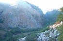 Kissamos at 39.2km (SW) A small village 21km away from Kastelli Kissamou,at 340 m. a.s.l with 57 permanent residents. The village is mentioned by Fr. Barozzi since 1577. A little before the village of Sassalos, starts the gorge of Salasse, a small one which leads to Tyflos river, and is worthy to walk.
 Rethymnon at 39.2km (SE) The village stands 17km away from Rethymno and 6km from Episkopi. It has 160 inhabitants, farmers and stock breeders. The first university of Crete, called VIVI'S ACADEMY operated here in 1540 AD. There are remnands of many Venetian Houses, such as Villa Barocci, a mint, a fountain etc.
 Gonia, Rethymno at 39.3km (SE) The Municipality of Nikiforos Fokas is located in the north of Rethymnon Prefecture. The area is known for its outstanding natural beauty and its historical tradition and architecture. All of the municipality's settlements are steeped in history and contain fine examples of architecture, featuring stone buildings with vaulted entrances (known as "diavatika") and magnificent thresholds. The municipality's jurisdiction extends over the fourteen former community wards of Agios Konstantinos, Ano Valsamonero, Atsipopoulo, Gerani, Gonia (Athanatos), Zouridi, Kalonyktis, Kato Valsamonero, Malaki, Mountros, Prines, Roustika, Saitoures and Frantzeskiana Metochia, which comprise a total of 21 villages.  Sfakia, South Hania at 39.5km (S) Ágios Pávlos (GR: Άγιος Παύλος)is a beach on the shores of Sfakiá between Agia Rouméli and Loutró. The pine trees from the high cliffs above almost reach the sea and form a unique landscape. The beach is sandy with pebbles with no facilities except for a small tavern. It can be reached only on foot ( about 1 hour walk from Agia Roumeli) or by boat. The picturesque small church of Agios Pavlos (Saint Paul) a byzantine basilica of the 10th century A.D. with frescoes, lies just a few meters from the sea. It is built with stones from the beach itself on the spot where Saint Paul reportedly baptised people on his way to Rome.
Image Library
 Sfakia, South Hania at 39.7km (S) Agia Rouméli (GR: Αγία Ρουμέλη)is a small fishing village, approximately two kms from the ending of Samaria Gorge. It is accessible only by boat from Paleohora, and from Hora Sfakion. It serves mainly as a stopover for visitors coming down the Samaria Gorge, and waiting for the boat to take them to Sfakia or Paleohora. However those who decide to stay for a couple of days or more will find apart from the unique scenery, a great beach with crystal clear water, plenty of interesting walks and a good choice of accommodations, taverns, cafés and stores. The place is also rich in history as it was inhabited since the antiquity. It is the site of the ancient city of Tárra (GR: Τάρρα), a famous cult place, that flourished from the Classical to the Roman times. Image Library
 Rethymnon at 39.9km (SE) It is built at 500m a.s.l. and 37km away from the city of Rethymno, with 400 inhabitants most of them farmers and stock breeders. It took its name due to its position, "MYRIOKEFALA" means myriads of heads (here :Hills). It is the birth place of George Maravelakis, a great fighter of the 1866 revolution against the turks. The monastery of Miriokefala, an interesting sight, devoted to the Holly Mother, was established by Ai Kir Giannis (a Cretan Saint) in the 11th century. There are many icons of Byzantine art, among them this of Holly Mother.
 Kissamos, Hania at 40km (SW) Α principal village located at 280m a.sl., on the main road to the southern coast, 47km from Hania and 22km from Kastelli with 370 inhabitants. There are a post Office and police station, workshops, olive press, wheat mill etc. The village lies at the entrance of the gorge of Topolia and 27 km away is the monastery of Chrissoskalitissa. The gorge is lush with plane-trees, wild olive trees, flowers, and bushes. Its walls are 300m high, and the width in some cases is 5m only. Through the gorge flows the river Tiflos. A little after the village, there is a well maintained footpath on the mountain side which reaches the Agia Sophia Cave at 285m a.s.l. The cave is of great scientific interest, has a diameter of 70m and it is 20m high. There are marvelous stalagmites and stalactites of various shapes. At the left end there is a small church with an icon that, as tradition says, came from Constantinople, and has been wedged in a rock. In the cave were discovered many finds from neolithic era. Two patron feasts are taking place there each year: One on Tuesday after Easter and a second on December 24, when the birth of Jesus is represented. 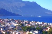 Kissamos, Hania at 40.5km (W) The beautiful town of Kissamos is located 42 km west of Hania and it is the capital of the Kissamos county. Kissamos is surrounded by beautiful landscape and has about 3.000 inhabitants. Kissamos is not a crowdy tourist resort, its development is based mostly in the wine and oil produce, and the agricultural products. Kissamos is built along a wonderful sandy beach. It is located where the ancient city of Kissamos stood. With Kissamos as a starting point you can visit the archaeological sites of Falassarna and Polyrinia, the Gramvoussa isles (pirate isles), the beautiful Georges of Topolia, Sirikari, the lagoon of Balos, the medieval villages, etc. |

|
|
|
| ||

C
O
N
T
E
N
T
S
O
N
T
E
N
T
S