interkriti®
YOUR GATEWAY TO CRETE
HOME
CRETE FACTS
NAVIGATE
EXPLORE

Agia Galini
Triopetra
Kissamos
Chryssi Isl.
Agia Marina
Balos
Gavdos isl.
Georgioupolis
SAMARIA
IDA Mtn
Palaiochora
Agia Roumeli
Sfakaki
Bali
Kalamaki
Matala
Lassithi
Plateau Lendas
Tsoutsouros
Vianos
Myrtos
Sfakia
Plakias
Ierapetra
Makrygialos
ZAKROS
Vai
Sitia
Agios Nikolaos
Elounda
MALIA
Hersonissos
Gouves
Chania
Rethymnon
Heraklion
GORTYN
FESTOS
KNOSSOS
|
|
Crete
List Grid Map
Found
149
- Showing :
101 - 120
 Rethymnon North at 39.1km (NW) A beautiful small town in the county of Rethymno with great views, natural water springs and lush vegetation. It's located at 260m a.s.l. between the rivers "Mousselas" and "Petres", 22km from the national road and 5km from Episkopi. Argiroupolis is the site of the ancient city of Lapa.
 Kenourgiou, Iraklion at 39.2km (NE) Priniás (GR: Πρινιάς) is a small village located 35km southwest of Iraklion town and 4km from Agia Varvara, at a height of 610 m above sea level. The village of Prinias lies on the border of three regions: Malevizi, Kenouriou and Monofatsi, and is recorded as forming part of all three regions in the censi.  Frangokastello at 40km (NW) Vatalos is the long beach to the west of the main beach of Frangokastello. It is a stretch of fine sand interrupted by pebbles and rocks that create small coves. There are no umbrellas and sun beds available for rent and the only shadow can be found under the little tamarisks. It is by far less crowded than the main beach. It is frequented mostly by the guests of the hotels that stand above the beach as it is peaceful, and, quite safe for the kids.
Image Library
 Milopotamos, Rethymno at 40.1km (NE) Anogia is a mountain town with 2500 permanent residents and is 55 km away from Rethymnon and 36 km from Iraklion. The name Anogia, means "high place - Ano Gi", is connected with the location that is built, in altitude of 700 m. Hospitable and pleasant residents have to tell a lot of old stories that have marked the tradition and the culture of the village. Anogia is a well-known village historically for its resident's resistance to the conquerors, Turkish and Germans.
Image Library
 Kenouriou, Iraklion at 40.1km (E) Megali Vrissi (GR: Μεγάλη Βρύση) lies 32km south of Heraklion, at 620 m above sea level. In the Barozzi document of 1577, it is mentioned as forming part of the province of Monofatsi and, in the Archives of Megalo Kastro (Heraklion), it is quoted in 1583 as having 71 inhabitants; there is also a reference to the village in the Basilicata document of 1630. The Turkish census records it with 47 families in 1671, and in the Egyptian one in 1834, it figures with 27 families. In the censi of 1881 and 1900 it is mentioned as a municipality in its own right with, respectively, 240 inhabitants and 307 inhabitants. As of 1928, it becomes a commune and today it counts over 900 inhabitants. Saint Constantine is the patron saint of the village. The churches of Aghia Anna and of the Panagia Almiri are worth visiting. The Aeolian Park, one of the islands pioneering projects, has been installed in Megali Vrisi and produces electricity of 5MW.  Cretan Singer and lyra player from Anogeia at 40.2km (NE) Nikos Xylouris (Greek: Νίκος Ξυλούρης, 7 July 1936 - 8 February 1980), nicknamed Psaronikos (Greek: Ψαρονίκος, "Grey Nick"), was a Greek composer lyra (Cretan lyre) player and singer from the town of Anogeia. He was part of the movement that brought down the Greek military Junta of 1967. His songs and music captured and described the Greek psyche and demeanor, gaining himself the title the archangel of Crete. Image Library
 Gonia, Rethymno at 40.8km (N) The Municipality of Nikiforos Fokas is located in the north of Rethymnon Prefecture. The area is known for its outstanding natural beauty and its historical tradition and architecture. All of the municipality's settlements are steeped in history and contain fine examples of architecture, featuring stone buildings with vaulted entrances (known as "diavatika") and magnificent thresholds. The municipality's jurisdiction extends over the fourteen former community wards of Agios Konstantinos, Ano Valsamonero, Atsipopoulo, Gerani, Gonia (Athanatos), Zouridi, Kalonyktis, Kato Valsamonero, Malaki, Mountros, Prines, Roustika, Saitoures and Frantzeskiana Metochia, which comprise a total of 21 villages.  Sfakia, South Hania at 41.1km (NW) Kalikratis is a small mountainous village at the foot of the White Mountains (Lefka Ori) at an altitude of 750m above sea level. It is a traditional village with many well preserved stone houses. A German army of two thousand soldiers, invaded the village during the October of 1943 , burned it down and executed twenty men and nine women who did not manage to leave on time. A little to the south of the village starts the gorge of the same name which is part of the European hiking footpath (E4) and after some 4km walking ends at the village of Patsianos.  Rethymnon Old Town at 41.1km (N) The Mosque took its name from the Turkish commander of the marine operations to conquer Rethymno, in 1646. During the Venetian Period, the Mosque became a monastery dedicated to St. Barbara. West from the central building, there is the deserted minaret of the mosque. The fountain of the Mosque is attached to the roofed entrance of the Mosque's garden, where believers washed before entering the Mosque and provided the area with fresh spring water. Image Library
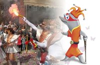 Rethymnon city at 41.1km (N) In winter the town of Rethymno lives in the rhythm of Carnival. Here, the grandest carnival on the island of Crete is organised. Apart from the great parade on Shrove Sunday, a large number of activities complete the framework of the Carnival festivities. The locals devotedly and cheerfully prepare for this season with creativity, they sacrifice their spare time and become young again while rejoicing and celebrating parties almost on a daily basis. More than 4,000 people have worked feverishly for months in order to present their masks and carriages on the great Carnival parade…The following day, on Shrove Monday people from the countryside play a leading part in the festivities. Unique traditions are revived in the villages and everybody is invited to participate in games, street performances and satires as for example “the kidnapping of the bride”, the “Cadi”, the “smudging of people”. These performances in combination with good wine and the music of the lyre are a successful formula for a unique experience. Links: www.carnivalrethymno.com  North West Crete at 41.2km (N) Rethymnon (GR: Ρέθυμνον) is the capital of the Prefecture of the same name and it is built between the two other large cities of Crete. The town still maintains its old aristocratic appearance, with its buildings dating from the 16th century, arched doorways, fountains etc. The Fortezza castle, at the top of a low hill named "Palaiokastro" dominates the town. It was built in 1590 to protect the city from the pirates raids and the Turks.
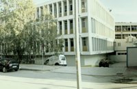 Rethymnon city at 41.2km (N) Rethymnon General Hospital is situated at 17, Trandalidou Str., close to the municipal gardens. The hospital has all major clinical specialties, outpatient clinics, intensive care unit and generally offers sufficient medical services throughout the prefecture of Rethymnon. 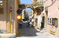 Rethymnon Old Town at 41.3km (N) The Guora Gate (Porta Guora or Grand Gate)) is the main entrance of the Venetian city walls that protected the city of Rethymno. The gate was built in the years of Rector Rettore Jocopo Guoro (1566-1568). Part of the gate is preserved at the beginning of the street "Ethnikis Antistaseos". It is 2,60 m. wide, built with carved stones with skew acnes, creating a semicircular arc on the top. According to traveler J. Gerola, the initial shape of the gate was formed by stepped cornice and pediment where a relief the lion of St. Marcos (the Venetian emblem) existed. Today the relief is preserved in two pieces and is stored at Loggia's courtyard. Old drawings of Guora Gate: inside the walls - outside the walls Image Library
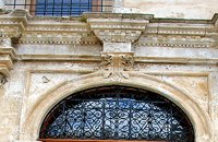 Rethymnon Old Town at 41.4km (N) The church of Saint Francis is one of the most important monuments of Rethymno. It was the main temple of the Monastery of the Franciscan Order. The architecture of the building - a single aisle Basilica type with wooden roof - and its ornaments are very interesting. Next to the east side of the temple two deserted chapels are preserved. Its Corinthian style main doorway is impressive, with capitals of composite order. During recent excavations around the church valuable archeological findings have been discovered, including two tombs of Venetian nobles. During the Turkish occupation the temple was turned into an "Imaret" (a shelter for the poor). It was also used as a cultural center until 1996. It was recently renovated to accommodate the Byzantine and Post-Byzantine Collection of the Prefecture of Rethymno.  Malevizi, Iraklion at 41.4km (NE) Ano Asites (GR: Ανω Ασίτες) lies 24km from Iraklion and 6km from Agios Myron at 480m a.s.l with 423 inhabitants. A big part of the surrounding area is covered by forest on the eastern side of the mountain Psiloritis. Near the village there is the Byzantine chapel of Agios Antonios located in the ravine with the same name a place of exceptional natural beauty. From here passes the European Hiking Path (E4) which leads to the shelter "Prinos" ( of the Mountaineering Club of Iraklion - altitude 1100 m a.s.l.) located in a holly (=prinos) forest.  Malevizi, Iraklion at 41.4km (NE) The monastery of Aghios Georgios the Gorgolainis (GR: Αγιος Γεώργιος Γοργολαΐνι) is located on an altitude of 400 m close to the Kato Asites village. It survived through several revolutions and wars during the Ottoman occupation.  Rethymnon Old Town at 41.5km (N) It is housed in the church of Agios Frangiskos in the center of the old town. It exhibits objects from the Neolithic to the Roman period, found at the prefecture of Rethymno (mainly Eleftherna, Monastiraki and Armeni). Clay figurines, funerary coffers, grave offerings, statues, grave steles, red-figure vases, bronze vessels, jewellery and glass vases, are some of the objects on display. St. Francis Church - 4 Agiou Fragiskou str., Telephone: +30 28310 27506 Email: efareth@culture.gr Open Winter: 08:00 - 15:00 November 1 - March 31 Summer: 10:00 - 18:00 April 1 - October 31, except Tuesday. 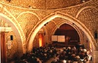 Rethymnon old town at 41.5km (N) During Venetian occupation the mosque Neratzes, which today is used as a conservatory, was the Augustinian church of the Holy Virgin. In 1657 the Turks transformed it into the mosque 'Gazi Housein' or 'Neratze', and in 1890 they added a large minaret with two galleries, which was built from the famous stones from the village of Alfa. The chapel of the Holy Virgin, situated at its west side and dedicated to the Body of Christ, was also transformed into a seminary. Outstanding elements of this building are the doorframe and the three domes.
Image Library
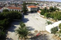 Rethymnon Old Town at 41.5km (N) The square of Mikrasiaton (GR: Πλατεία Μικρασιατών) formerly the 1st primary school square, in Rethymnon town, covers an area of 7,500 square meters, right at the heart of the city's historical center. It is surrounded by valuable monuments and beautiful buildings, mainly used as cultural centers. There, visitors have the opportunity to rest in a peaceful environment and at the same time visit the various monuments and cultural centers located in the area. Image Library
 Rethymnon town at 41.6km (N) Rethymnon old port was of great strategic importance during the Venetian period. It was only able to accommodate small ships. From 1300 until today, the Venetian port has undergone numerous constructions. The 1618 wall that surrounds the port from the east is restored today with some recent interventions and additions. The original lighthouse was constructed during the Turkish period and was later replaced by another one. The building on the southeast part of the port was constructed in 1931 and functioned as a customs office. On the same location it is estimated that there was a quarantine house during the Venetian period. The vaulted spaces on the two or three-floor buildings at the port have been transformed to little and picturesque fish taverns, where visitors can enjoy the secrets of the Cretan cuisine.
|
||
|
| ||


)
)
)
)
C
O
N
T
E
N
T
S
O
N
T
E
N
T
S