interkriti®
YOUR GATEWAY TO CRETE
HOME
CRETE FACTS
NAVIGATE
EXPLORE

Agia Galini
Triopetra
Kissamos
Chryssi Isl.
Agia Marina
Balos
Gavdos isl.
Georgioupolis
SAMARIA
IDA Mtn
Palaiochora
Agia Roumeli
Sfakaki
Bali
Kalamaki
Matala
Lassithi
Plateau Lendas
Tsoutsouros
Vianos
Myrtos
Sfakia
Plakias
Ierapetra
Makrygialos
ZAKROS
Vai
Sitia
Agios Nikolaos
Elounda
MALIA
Hersonissos
Gouves
Chania
Rethymnon
Heraklion
GORTYN
FESTOS
KNOSSOS
|
|
Crete
List Grid Map
Found
163
- Showing :
141 - 160
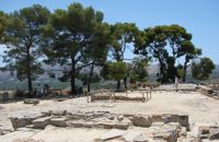
North Wing Phaistos Palace at 47.1km (SE) The North Wing is one of the most important wings of the Palace, as it is believed to have housed the "Royal Apartments". lt also contained sets of rooms, inner courtyards, corridors and staircases leading to the upper floor. The splendid gateway on the north side of the Central Court led to the complex of the "Royal Apartments". It is framed by two magnificent wooden half-columns, now reconstructed. On either side of the gateway are two niches decorated with wall paintings, in which the gate guards may have stood. Behind the gateway is a wide corridor with a drainage duct, which led to an inner courtyard, which in turn led to the "Royal Apartments" complex. The term "Royal Apartments" was established by the excavators, who followed the terminology applied by Evans to similar areas at Knossos. They are undoubtedly official apartments with particular architectural features, such as open balconies and colonnades, polythyra (pier-and-door partitions), lightwells and "Lustral Basins". The gypsum slab flooring and colourful wall paintings gave these apartments a particularly luxurious appearance. 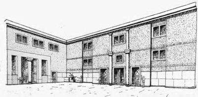 Image Library
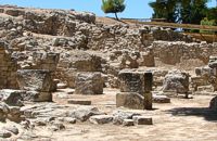
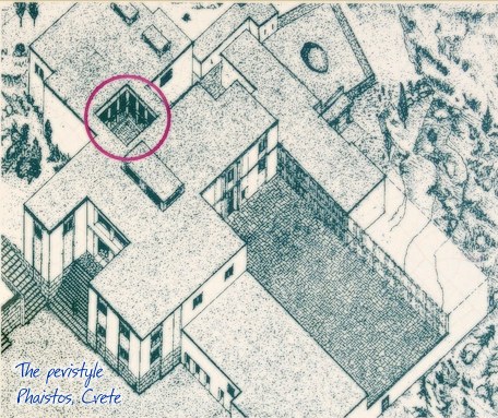
Peristyle Phaistos Palace at 47.1km (SE) The open peristyle court was one of the most elegant inner courtyards of the New Palace. It consisted of an impressive peristyle with four columns on each side supporting the corresponding colonnades, while the central area remained open. The same construction appears to have continued on the upper floor, with a second row of columns. The peristyle court was a focal point of the Palace with access routes leading from here to the "Royal Apartments", the Propylaea and the Central Court. The ruins visible on a lower level in the centre of the peristyle belong to a house of the Prepalatial settlement (3200-1900 BC).
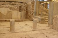
 Phaistos Palace at 47.1km (SE) The northernmost of the "Royal Apartments" has been identified as the King's Megaron and bears a striking resemblance to the corresponding "King's Megaron" at the Palace of Knossos. It consists of a spacious central hall with impressive polythyra (pier - and - door partitions) on the north and east sides. The east polythyron communicates with a second room with two columns, which opens onto a large light-well to the east. The gypsum slab flooring with red plaster filling, the interstices, gave the whole complex a particularly sumptuous air. The north side of both rooms opens onto a spacious colonnade with columns set far apart, offering a magnificent view of Mount Psiloritis and the sacred Kamares Cave. A long corridor at the back of the polythyron room leads to the impressive "Lustra1 Basin" of the Megaron. The whole apartment was decorated with colourful wall paintings depicting linear and plant motifs. Image Library
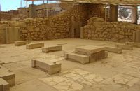
 Phaistos Palace at 47.1km (SE) The southernmost of the "Royal Apartments" ofPhaistos has been identified as the Queen'sMegaron. It consists of a beautiful, spacioushall with a double colonnade opening ontoa light-well. The floors are paved with gypsum slabswith red plaster filling the interstices. Gypsumwas also widely used for the benches runningaround the walls of the Megaron and the facingof the lower part of the walls. The upper walls aredecorated with frescoes depicting plant motifs. Twobeautiful rhyta (libation vessels) were found here: one is decorated with the cult symbols of thedouble axe and sacral knot, while the other bears areed pattern. The two staircases to west and north led to the upper floorof the Megaron and the peristyle, where one of the mainentrances to the "Royal Apartments" was located. Image Library
 Messara, Iraklion South at 47.2km (SE) Kamilari is a quiet, traditional village, with a panoramic view to the endless olive groves of the Messara valley on the one side, and to the Libyan sea on the other side. It has been inhabited since the Minoan period. One of the seven wise men of the ancient world, Epimenidis, a great wise man and a soothsayer, lived in a small community outside Kamilari, called Metohi.
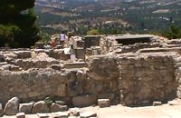 Phaistos Palace at 47.2km (SE) Almost the whole south part of the West Wing was dedicated to the shrines of the New Palace. The main architectural types of shrine are the "Bench Shrine" and the "Lustral Basin". The first type consists of small, rectangular rooms with low benches running round the walls, perhaps to support cult objects and figurines of the deity. On some of them were found female figurines, ritual vessels and "Offering Tables" (small altars). On the walls of some rooms are incised sacred symbols, such as the double Axe and the star. The "lustral Basin" type consists of rooms which are set somewhat lower than the surrounding structures, with a few steps leading down into them. The were usually lined with slabs of gypsum, giving them a highly - finished appearance. Although it is doubtful that these structures contained water, it is thought that they were used for purification rituals. There is a third type of Minoan shrine in the S-E part of the shrine wing. Its is a room with central pillars (Square, stone - built columns) thought to be a cult area, similar to the "Pillar Crypts" of the Palace of Knossos, where the sacred pillar was worshiped by pouring libations. 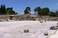 Phaistos Palace at 47.2km (SE) The great Central Court is a basic architectural element of Minoan palaces and the core around which the different wings are set. It was the focus of the economic, social and religious activity of the palace, the setting for events which could be watched from the windows and balconies. The Central Court of the Palace of Phaistos was built in the time of the Old Palace (1900-1700 BC). It was also used in the New Palace with minor alterations to its orientation and dimensions. It is a rectangular paved, open area with colonnades running along both its long sides, with alternating pillars and columns which supported open colonnades.On the west side of the court, two adjoining rectangular rooms with benches, open on to the Central Court, may have been "sitting rooms" for the spectators watching the events taking place in the Central Court. In the east colonnade of the court, some stone-built benches next to a water cistern may have formed islands of rest and recreation. The stepped structure in the NW corner of the court may have been an altar for the ceremonies which were held here. The pithoi (large storage jars) in front of it were found in buildings founded in the site of the Great Court after the destruction of the Palace. Image Library
 Phaistos Palace at 47.2km (SE) The complex of four rooms on the northeast edge of the Palace does not belong to the Old Palace, although it directly adjoins it. In the westernmost building is an elongated rectangular room with partitions of vertical clay slabs. Similar "cists" in the Palaces of Knossos and Zakros were used to store valuable ritual vessels. Here they were found empty. Next door, in the narrow rectangular room to the southeast, was found a clay tablet inscribed in Linear A and the famous "Phaistos Disc" bearing hieroglyphic writing. The building was therefore named the Palace "Archive" The building east of the Archive is thought to be a shrine or the archivist's residence, while the easternmost building is known as the "Potter's Workshop" because a large number of unfinished pots were found there. The intermediate building has an impressive peristyle of alternating pillars and columns. A staircase on the south side of the peristyle building connects the whole complex to the NE entrance to the Palace, which stood in this spot. Image Library
 Phaistos Palace at 47.2km (SE) The east part of the North Wing forms the workshop area of the Palace. It consists of the East Court and a complex of small rooms which are believed to be the workshops of the New Palace (1700-1450 BC). Approximately in the centre of the court are the ruins of a horseshoe-shaped kiln. The elongated rectangular building with 6 rooms on the west side of the court appears to have been used for the workshops of the kiln craftsmen. The square room on the north side of the court was the gatehouse of the northeast entrance to the Palace. It has gypsum slab flooring and benches around the walls. Behind it is a long corridor leading to the inner courtyard of the North Wing and thence to the "Royal Apartments" Image Library
 Messara Bay, Iraklion at 47.5km (SE) One of the most beautiful sandy beaches of Crete, extends from a clump of rocks riveted in the shallow waters in the south to the Kalamaki settlement in the North. In Minoan times there used to be the ancient port of Phaistos. The antiquities lie just a few meters away from the sea.
Image Library
 Kenouriou, South Iraklion at 47.6km (SE) Zaros (Greek: Ζαρός), at an altitude of 340 metres, is a town with a lake and gorge nearby. It has a couple of hotels and it is 44 km from Heraklion at the southern foothills of Mountain Psiloritis. The population of 3,400, produce olive oil, sultanas, vegetables and spring water. There are a couple of fish farms that serve both trout and salmon. In Zaros, there are cafes near Lake Votomos, as well as a tavern that serves fresh trout called I Limni (The Lake). Close by is Rouvas Gorge, which is part of the Psiloritis mountain range and is on the hiking route known as the E4 European Walking Path. Nearby Zaros are traditional water mills which have been working since the 16th century, as well as archaeological sites and monasteries. Zaros is also famous for its water "ZAROS" bottled by a company called Votomos SA.  Sfakia, South Hania at 47.8km (W) Agia Rouméli (GR: Αγία Ρουμέλη)is a small fishing village, approximately two kms from the ending of Samaria Gorge. It is accessible only by boat from Paleohora, and from Hora Sfakion. It serves mainly as a stopover for visitors coming down the Samaria Gorge, and waiting for the boat to take them to Sfakia or Paleohora. However those who decide to stay for a couple of days or more will find apart from the unique scenery, a great beach with crystal clear water, plenty of interesting walks and a good choice of accommodations, taverns, cafés and stores. The place is also rich in history as it was inhabited since the antiquity. It is the site of the ancient city of Tárra (GR: Τάρρα), a famous cult place, that flourished from the Classical to the Roman times. Image Library
 Malevizi, North - West Iraklion at 48km (E) Ahláda (GR: Αχλάδα) is a small village located 24 kms west of Iraklion at an altitude of 300 meters a.s.l. It is close to the tourist resorts of Agia Pelagia and Ligaria, and it has approximately 500 inhabitants, most of them farmers and stock breeders. The name of the village meaning wild pear tree is given probably due to the huge wild pear tree that used to be at the village.  Moires, Messara at 48.3km (SE) The monastery of Panagia Kaliviani is located at the 59th km on the road Iraklion-Phaistos. The monastery was built during the second Byzantine period. The small Byzantine chapel was painted with frescoes but most of them are today destroyed. The chapel was deserted until, during the Turkish occupation in 1873, an old small icon of the Annunciation of the Holy Mother was miraculously found there.and the monastery became a place of worship.  Messara, Iraklion South at 48.3km (SE) The village of Pitsidia is located 65 km southwest of Iraklion at an altitude of 80 m a.s.l, just before the magnificent bay of Messara. The village with aproximately 700 inhabitants is the oldest village of the area and is refered (by S. Spanakis) that it was the place where the soldiers of Nikiforos Fokas, commander of the Byzantine army, settled. The army, famous for its bravery, came from Pisidia of the south Asia Minor, and this is probably the origin of the name Pitsidia.
Image Library
 Lefka Ori, Hania at 48.4km (W) Kallérgi Mountain Refuge is located on the western region of Crete, above the plateau of Omalos, in the White Mountains (Lefka Ori) mountain range at an altitude of 1680 metres. The site is of unique natural beauty and commands great views to the surrounding peaks and the gorge of Samaria. It can be accessed by car or on foot (1 1/2 hour) via the 5km long dirt road from Omalos. The refuge can accommodate up to 50 people. It features a fully equipped kitchen, a lodge with fire place and wood burning stoves, toilets (indoors and outdoors) and a camping area. Electricity is supplied by a generator. Kalergi refuge operates throughout the year (from November to March only on weekends) For more information please visit:Mountaineering Club of Hania  by Richard Ellis at 48.4km (W) 1st September - The last two days of the walk were rather low key after the drama of the White Mountains. I left Kallerghi at 0800 after a proper Austrian mountain breakfast served up by my new Bulgarian friend Daniel. It is about an hour down the dirt road to the Omalos plateau and half way down I realised I had left my beloved katsouna (shepherd's crook) at the hut. I couldn't bear the prospect of going all the way back up so I rang Joseph to say that I would collect it the following week. I have learnt that it is now forbidden to cut sticks from the wood of the rare ambelitsia tree so mine is now a museum piece (with the distinction of having walked 450 kms across Crete). Distance: 28.4 km Time: 8 hrs. 20 mins. Mov av 4.2 km/hr Height: 405m.  Messara, Iraklion South at 48.7km (SE) Gallia is one of the oldest villages of the area. It is mentioned as a location in the Venetian records as early as 1577, and as a village with 120 residents since 1583. The renaissance tower in the village (still imposing although rundown) and the water fountains in the Kapeloniana area are proof of the passing of the Venetians. Part of the village, called Monohoro, is mentioned as early as 800 A.D.  Messara, South - West Iraklion at 48.8km (SE) Matala (GR: Μάταλα) was the ancient port of Phaistos and Gortys and a former fishing community which has developed into a modern holiday center. It is located 4 km south-west of the village of Pitsidia and 75 km from Iraklion. It is built on the coast line of the Messara bay inside a small and picturesque inlet. During the 60's the caves of Matala were hosting a hippie commune.
 Malevizi, North - West Iraklion at 49.3km (E) Kroussónas (GR: Κρουσώνας) is an historical town built in a semi-circle on the eastern slopes of the Psilortis (the highest mountain in Crete), between the hills of Koupos and Livadiotis, at 460 meters above sea-level. It is at a distance of 21 kilometres from Heraklion. A magnificent 10kms route, ideal for nature-lovers is that from Kroussonas to the wood of Vromonero at 1300m a.s.l.
|
|||
|
| |||


C
O
N
T
E
N
T
S
O
N
T
E
N
T
S