interkriti®
YOUR GATEWAY TO CRETE
HOME
CRETE FACTS
NAVIGATE
EXPLORE

Agia Galini
Triopetra
Kissamos
Chryssi Isl.
Agia Marina
Balos
Gavdos isl.
Georgioupolis
SAMARIA
IDA Mtn
Palaiochora
Agia Roumeli
Sfakaki
Bali
Kalamaki
Matala
Lassithi
Plateau Lendas
Tsoutsouros
Vianos
Myrtos
Sfakia
Plakias
Ierapetra
Makrygialos
ZAKROS
Vai
Sitia
Agios Nikolaos
Elounda
MALIA
Hersonissos
Gouves
Chania
Rethymnon
Heraklion
GORTYN
FESTOS
KNOSSOS
|
|
Crete
List Grid Map
Found
37
- Showing :
21 - 37
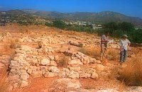
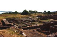 Sitia, East Lassithi at 17.7km (N) At the northernmost edge of the eastern coast of Crete lie the ruins of a settlement which flourished during the Late Minoan period (1550-1220 B.C.). At the same site, however, are preserved remains of the Early and Middle Minoan periods (3000-1550 B.C.), mostly cemeteries with well-built ossuaries, and ruins of spacious houses. The site ceased to be inhabited at the same time when Zakros was abandoned (1450 B.C.) but was reoccupied during the Late Minoan III period (1300-1200 B.C.). The city covered a total area of more than 50,000 sq.m., was densely inhabited but not fortified. To the NE of one of the city's sectors lies the sanctuary of Diktaian Zeus, which belonged administratively to the city of Itanos. Cult practice was continuous from the Geometric period (8th century B.C.) until the Roman conquest. It seems that the sanctuary was plundered and destroyed by fanatic Christians at the end of the 4th century A.D. Image Library
 Sitia, East Lassithi at 19.7km (NW) Piskokéfalo (GR: Πισκοκέφαλο), a principal village located 3 km south of Sitia. Piskokefalo is the birth place of the great poet Vincentzos Kornaros, who wrote the masterpiece of Medieval poetry, "Erotokritos". The village is mentioned at the census of 1577 by Fr. Barozzi, and became the seat of the commanding officer, after the destruction of the town of Sitia in 1538 by the pirate Chairentin Barbarossa. Nowadays Piskokefalo is a beautiful village where a stop is worthwhile. The visitor can see the house of Kornaros, enjoy a coffee or a meal at the village's square, visit the spring at Zou, the old water mill, the church of "Agia Anna" and the small chapel of "Panagia Trapezounta".  masterpiece of the Cretan Renaissance at 19.7km (NW) Erotokritos (GR: Ερωτόκριτος) has been characterized as a masterpiece of the Greek language which unites the magic of myth and a deep understanding of everyday life. It expresses the "threefold ideal which is bravery, beauty and wisdom." A work rooted deeply in authentic Greek traditions, humanity, true feeling and pure love for life and freedom. The story takes place in Athens where King Herakles lives with his wife Artemis and their very beautiful daughter Aretousa, with whom the handsome and brave young man Erotokritos, son of the king's advisor, has fallen in love. After many difficulties and trials, the couple is married amidst celebrations and magnificent contests. The world of this work is the ideal Greek world of friendship, pure feelings, authentic Greek traditions. It is the world of the beauty of Athens and Crete which is "the throne of virtue and the river of wisdom." The language of this work is authentic Greek and Cretan, a synthesis and conscious effort of the poet to express lofty human feelings and values with simplicity, directness and truth. The poem was written by Vitsentzos Kornaros (1553-1613/14) a noble Cretan from Sitia with a very strong presence in Greek letters.  Cretan poet of the Greek Renaissance at 19.7km (NW) Vitsentzos or Vikentios Kornáros (GR: Βιτσέντζος or Βικέντιος Κορνάρος) or Vincenzo Cornaro (March 29, 1553 – 1613/1614) was a Cretan poet of the Greek Renaissance who wrote the romantic epic poem Erotokritos. He was a leading figure of the Cretan Renaissance. Not many biographical sources exist about Kornaros himself apart from the last verses of Erotokritos. It is believed that he was born to a wealthy family in Trapezonda near Sitia, in 1553, and lived there roughly up to 1590. He then moved to Candia (present Iraklion), where he married to Marietta Zeno. Together they had two daughters named Helen and Katerina. Image Library
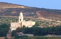 Sitia at 20.2km (N) It is an historical monastery of the 15th century, which collapsed in the earthquake of 1612 and was rebuilt with the financial aid of the Venetians. During the Ottoman conquest of Crete, the monastery was destroyed and devastated by the Turks. In 1704 the monastery was declared stauropegion. During the Ottoman occupation there was a school in the monastery, while, after 1870, it was founded there a school of mutual teaching. The Monastery is a stauropegion fortress. The main building of 800 m2 has three floors, which are divided into cells, guest - houses, kitchens, the abbot' s residence and warehouses. The katholicon is a two-aisled church; the northern aisle is dedicated to the Virgin, and the southern posterior aisle, to St John the Theologian. The monastery' s characteristic bell tower bears relief crowns and crosses with inscriptions and the date 1558. In the Monastery, there is also an interesting Museum.
Image Library
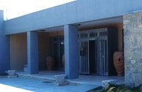 Sitia town at 21.5km (NW) Rich displays cover the periods 3500 B.C to 500 A.D. The oldest artifacts come from the wider region of Sitia. The museum is divided into five chronological parts and displays include a valuable collection of vases, clay tablets in Linear A script which were found in the archives at Zakros, figurines from peak sanctuaries, a wine press from the neo-palatial period and a Hellenistic wheat mill. Of special interest is the ivory and gold male figurine which was found in Roussolakkos near Palekastro.
 Sitia, East Lasssithi at 21.9km (NW) The easternmost town in Crete. A small and pleasant coastal town, built in a semicircle on the western side of the Bay of Sitia (Si̱teía GR: Σητεία), a typical, peaceful Mediterranean port. It is the capital of the county with the same name and is sited 69 km east of Agios Nikolaos.
Image Library
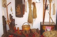 Sitia town at 21.9km (NW) The Folklore Museum of Sitia (Siteia, GR: Σητεία) displays items from the 19th and early 20th centuries. It includes some unique embroidery, examples of traditional weaving, wood carvings, local dress and household items, all displayed in an authentic Sitian house setting. Address : 28, Kapetan Sifi Str., 72300 Sitia 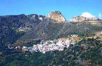 Sitia, East Crete at 22km (W) Péfkoi (GR: Πεύκοι). A typical Cretan village, built at 420m above sea level, with narrow paved streets and old stone built house. There are many places worth to visit in the area. The folklore museum, housed in a small well preserved building located by the old school, provides information on the history and the day to day life of the village. At the top of the overlooking hill, named "Kastelopoulo" there is a building of the Late Minoan period which used to be a watchtower or a beacon. The 7km long road from Makrygialos to Pefkoi passes through the "Pefkiano" gorge, a wonderful landscape with plenty of pine trees (=pefko) who gave their name to the village. Approaching the village we see the dirt road that leads to the miracle working church of Agios Georgios Semekides, celebrating every year at November 3rd. 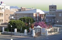 Sitia, Lassithi at 22km (NW) The hospital provides full medical treatment and services. Website: www.ghsitia.gr Xerokamares, 72300 SitiaTel : 2843 3 40 100 FAX : 2843 0 25 352 - 2843 3 40 200 E-mail: ghsitia@ghsitia.gr 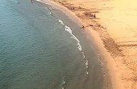 Sitia south at 23km (W) A one kilometre long beach, with fine gold sand and shallow waters, lies right in front of the town of Makry Gialos. It is accredited with the blue flag and is considered to be one of the safest beaches for swimmers of all experience and children due to its soft and gently shelving. It is an organised beach with sun-beds, umbrellas and most sea sports facilities. 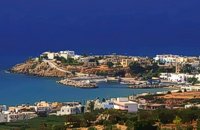 Sitia south at 23.4km (W) Makry Gialos (Long shore GR:Μακρύ Γιαλός) is a small beach resort on the south-east coast of Crete, located 60km from Agios Nikolaos, 25km from Ierapetra, and 33 km from Sitia. Makry Gialos features a small fishing harbour and a nice 1km long sandy beach that stretches from the harbour to the east. Four more lovely beaches can be found in the immediate area. Accommodation is available mostly in family-run studio and apartment complexes and there is a good choice of bars, restaurants, tavernas, some of them right on the beach front or at the small fishing harbour. Makry Gialos is the administrative centre of the wider area which comprises some picturesque traditional villages built on the tree covered mountain sides. The area has been inhabited since the Minoan times as many ruins from this as well as the Roman and the Venetian periods prove.  Sitia south at 23.6km (W) In Makry Gialos, at the place Katovigli, near the church of the Dormition of the Virgin, have been unearthed remains of a Roman Villa. Pendlebury (BSA XXXIII p. 100) had already noted the existence of a Roman settlement here. Excavations begun in 1977 (not yet completed), have shown that there were indeed large domestic establishments, dated from the 1st century BC to the 3rd century AD, but it is not possible at this stage of the excavations to draw definite conclusions. One room after another has been discovered and the whole excavation so far, covers an area of roughly 1500 sq.m.  Sitia, East Lassithi at 24km (N) A palm tree forest stretching on a marvelous valley and sandy beach. It consists of self planted palm trees of Theophrastus (Phoenix Theophrasti). It is unique of its kind in Greece, Europe and probably the world. Vai because of its special value and beauty is protected by the Greek state, European Union and international contracts. The protected area covers 23.4 ha. The sandy beach of Vai is amongst the most beautiful in Crete and Greece and attracts thousands of visitors every year since Vai is a top destinations especially for the new comers. The small islets opposite the beach add a lot to the beauty of the place. There is a parking area, a tavern, a canteen, umbrellas and seabeds. There is regular public bus connection with the towns of Sitia and Palaikastro during the summer and many organised day trips by travel agencies. If you don't like crowds, you can walk a little to the south from Vai to Psili Ammos a lovely small beach with fine gold sand which is nested in a small cove. Image Library
 Sitia south at 24km (W) In 1971 systematic excavations were begun by the Ephor of Antiquities Kostis Davaras north-west of the village at Plakakia. Here he located an important villa of the lateminoan period. The dig was completed in 1977 having shown that the villa had been destroyed by fire.It had strong outer walls, inner courts, many rooms with thresholds, flagged floors and areas perhaps connected with the worship of the Sacred Tree. It must have been roofed with bamboo canes covered by a layer of clay (as a number of the older traditional village houses still are). Among the most important movable finds were vessels of pottery and stone, figurines and an amygdaloid seal-stone of steatite engraved with a representation of a Sacred Ship. On the ship a sacred precinct or altar is shown with a tall palm-like tree standing like a mast. On the prow of the ship a worshiper or a priestess stands facing the altar, clenched fist raised to the brow in the recognized Minoan attitude of worship. This is the first clear evidence of the existence of Sacred Ships or Boats connected with the Minoan religion; it has its parallels in the ancient religions of Egypt and Mesopotamia. Source: "Sitia" by Nikos Papadakis - archaeologist Image Library
 Richard Ellis walk: Day 4 at 29.1km (W) June 4th - There now followed two 30-plus kilometer days aggravated by the fact that I wanted to summit each range that I passed through - even though there is no strict E4 requirement to do this. So, I set off from Orino by 7.00 am on the clearly marked dirt road which is the pass through the mountains towards the village of Thripti. Distance:32.2 km Time: 11.5 hrs. Mov av 4.2 km/hr Height overnight: 330m.(max 1,476m.)  Sitia, East Crete at 29.7km (NW) The village of Tourloti (GR: Τουρλωτή) is located in Eastern Crete, on the road from Agios Nikolaos to Sitia. Tourloti is 42 km from Agios Nikolaos and 27 Km from Sitia. Tourloti is a small, traditional village, the largest of a group of four, dotted across the hillsides in this area. It has changed little in the past few decades, and remains untouched by tourism. However, it retains a healthy vibrant Greek community, of families living and working in the local area. The village has a prominent church, primary school, two small mini-markets, a bakery, chemist, post office, two kafenions and one small traditional taverna. The narrow streets with white washed houses, flower filled alleyways, and glimpses of spectacular views, give the village a unique, timeless sense of tranquility, far removed from modern city life. It is the centre for several religious celebrations and festivals, especially over Easter and the summer months. |
||
|
| ||


C
O
N
T
E
N
T
S
O
N
T
E
N
T
S