interkriti®
YOUR GATEWAY TO CRETE
HOME
CRETE FACTS
NAVIGATE
EXPLORE

Agia Galini
Triopetra
Kissamos
Chryssi Isl.
Agia Marina
Balos
Gavdos isl.
Georgioupolis
SAMARIA
IDA Mtn
Palaiochora
Agia Roumeli
Sfakaki
Bali
Kalamaki
Matala
Lassithi
Plateau Lendas
Tsoutsouros
Vianos
Myrtos
Sfakia
Plakias
Ierapetra
Makrygialos
ZAKROS
Vai
Sitia
Agios Nikolaos
Elounda
MALIA
Hersonissos
Gouves
Chania
Rethymnon
Heraklion
GORTYN
FESTOS
KNOSSOS
|
|
Crete
List Grid Map
Found
175
- Showing :
121 - 140
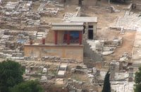
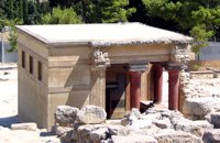
 Knossos Palace at 25.5km (S) The magazine to the north of the Grand staircase took its name from the pithoi (large storage jars) that were found here. The jars have relief disk and rope decoration, a characteristic of the beginning of the New palace period (1700-1450 B.C.). A variety of finds show that the place had also been used as a magazine in the Old Palace period (1900-1700 B.C.). Next door is the "Corridor of the Bays", where three small openings were used for storage. Many vases and religious artefacts were found here. The magazines were buried at the end of the New Palace period(1700-1459 B.C.). Image Library
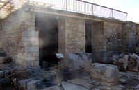
 Knossos Palace at 25.5km (S) Here is the so-called "School Room", an area where, according to Evans, scribes were taught to write on clay tablets. He supposed that they kneaded the clay in the built mortar next to the bench. It is more likely, however that it was a workshop for ceramics or wall-painting. Behind the "School Room" is the "Lapidary's Workshop", where blocks of crude or semi-worked lapis lacedaemoniae (spartan basalt) and stone tools were brought to light. According to Evans, the main workshop lay on the upper floor from which vases and large stone amphora had fallen to the ground floor. 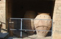 Knossos Palace at 25.5km (S) Here the excavators found a number of very large storage jars (Pithoi) and Evans named the place the "Magazines of the Giant Pithoi". These magazines are one of the older parts of the palace. The pithoi stand out for their size, the number of handles and the richness of their relief decoration with ropes and discs. To the right of the magazines a staircase which has been reconstructed by Evans descends to the east entrance of the Palace. The entrance is a robust construction that gives the impression of a "bastion". From this point it would have been easy to reach an important building of the palatial period, the so-called "Royal Villa" which lies outside the main archaeological site. Image Library
 Knossos Palace at 25.5km (S) The Royal Gaming Board was found here, a kind of board game made of ivory, rock crystal, Egyptian blue, silver and gold, now in Heraklion Museum. To the right of the corridor are the "Royal Pottery Stores", where Kamares pottery of the Old Palace period (1900-1700 B.C.) was uncovered, and to thee left, storage and workshop areas. Image Library
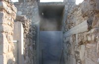
 Knossos Palace at 25.5km (S) An open air narrow passage linked the Central Court with the North Entrance. It was paved and had a strong inclination towards the north. Right and left were two raised colonnades known as "Bastions". Arthur Evans reconstructed the "Bastion" on the west side. He also placed a copy of a restored relief fresco of a bull here. The wall painting may have formed part of hunting scene. The passage ends in a large hall with ten square pillars and two columns. The pillars and columns probably supported a large hall on the upper floor. Evans suggested that, due to its position on the seaward side, it was here that the produce of seaborne trade would have been checked when it reached the Palace. It was therefore named the "Customs House". Image Library
 Knossos Palace at 25.5km (S) This room, located beside the north entrance, resembles a cistern. Its floor is lower than the surrounding area and is reached by steps. The "Lustral Basin" was surrounded by columns and was lined with slabs of gypsum giving it a luxurious appearance. In its present form, the area has been completely reconstructed by Evans. Areas with a similar arrangement have been found in other parts of the palace of Knossos, as well as other palaces and important Minoan buildings of the period (1700-1450 B.C.). It is not known how these places were used. However, from their construction it seems that theu would not have been filled with water, nor was there any drainage. Evans thought that they were used in purification ceremonies and therefore called these places "Lustral Basins". Evans also believed that the Palace was a sacred place. That is why, in his opinion, the "Lustral Basin"in question was used to purify visitors going into th Palace via neighbouring North Entrance. Image Library
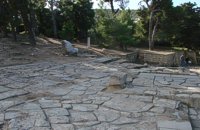 Knossos Palace at 25.5km (S) This area, sited at the north-west edge of the palace, was called the "Theatre" by Evans because its shape reminded him of later theatres. It is a platform and rows of steps that form a right angle. At the base of the stairs is the end of a narrow elevated road that crosses a paved court. Evans believed that the court was used for ceremonies watched by the standing viewers. The elevated paved road continues in the opposite direction. It passes underneath the modern road to Heraklion, connecting the Palace with the Minoan town, which extended to the West and North. Evans named the road the "Royal Road". Along the length of the road are town houses with workshops on the ground floor and residential areas on the upper floor. Image Library
 Knossou Av. Iraklion at 25.7km (NE) The General Hospital of Heraklion "Venizeleio & Pananio", named after the great statesman Eleftherios Venizelos, is one of the largest hospitals in Crete with 500 organic beds. It is located 4km away from Heraklion center on the road to Knossos, and occupies an area of 25,000 sq. meters. Venizeleio hospital provides high quality health services to citizens in a friendly and human environment. It was established in 1953 by a donation of Cretans of America and worked initially for Pulmonary Diseases. It was for many years the major hospital in East Crete. Telephone: (+30) 2813 408000 Website: www.venizeleio.gr/  Malevizi, Iraklion at 25.8km (N) Dóxa (GR: Δόξα) is a pretty village built on a height of 400 metres above sea-level and 20 kilometres to the west of Heraklion on the road to the mountainous Milopotamos. The historical cave of Dóxa (GR: Δόξα) is located in a short distance from the village of Marathos on the road to Heraklion. It is at a height of 490 metres above sea-level, near a well-known taverna also called DOXA. The cave has a total length of 50 metres and impressive stalactites and stalagmites.  Messara, South - West Iraklion at 25.9km (SW) Matala (GR: Μάταλα) was the ancient port of Phaistos and Gortys and a former fishing community which has developed into a modern holiday center. It is located 4 km south-west of the village of Pitsidia and 75 km from Iraklion. It is built on the coast line of the Messara bay inside a small and picturesque inlet. During the 60's the caves of Matala were hosting a hippie commune.
 Iraklion at 25.9km (N) Ammoudara (GR: Αμμουδάρα) is four kilometre long sandy beach that stretches from the west end of Heraklion to Linoperamata near the village of Gazi. The sand is fine and blond and extends several metres to the land and the sea is clear and safe. The predominant winds during the summertime are N, N-W usually "meltemi" that get more fresh at the western end of the beach, where the windsurf school is located. Along the shore there are hotels, some of them very large complexes, taverns, restaurants, bars, cafes etc that offer umbrellas and sun-beds on the beach. There are also lifeguards in some spots. The area in general is touristic and offers a full range of facilities, among them the modern multiplex "Technopolis" with cinema and an open-air theater. Image Library
 Iraklion at 26.3km (NE) The monastery of Agaráthou (GR: Μονή Αγκαράθου), dedicated to the Virgin, stands at an altitude of 538m, on "Soros Panteli", a rocky hill between the villages of Sgourokefali and Sabas, 23 km from Heraklion. During the period of Venetian rule it was a centre of learning, producing many famous churchmen including the Patriarchs Cyril Lucaris, Meletius Pegas and Sylvester the Cretan. The church was rebuilt in 1894 and flourished once more after the end of the Turkish occupation. Young, educated monks with university degrees have recently settled in the monastery, restoring it to its former glory.  North - Central Crete at 26.4km (NE) Iraklion (Heraklion or Herakleion GR: Ηράκλειον) is the largest urban centre in Crete, the capital of the region and the economic centre of the island. The first European civilisation, the Minoan civilisation, flourished on this land 5000 years ago. Currently the population of Iraklion is approximately 150.000 people. It is a very dynamic and cosmopolitan town, particularly during the summer period when thousands of visitors can be seen shopping in the market or visiting the museums and other places of interest. Today Heraklion is the top choice for tourist destinations in the Mediterranean. The city is also the commercial and scientific centre of the island. During the last 20 years the city has made remarkable progress in the academic and technological fields...
Image Library
 Matala, South - West Iraklion at 26.4km (SW) The Red beach is located around 700m south from Matala. It is a beautiful secluded beach with fine reddish sand originating from the rocks of the area. The name "Red Beach" is given by the visitors due to its reddish color while its original name is Ammoúdia (GR: Αμμούδια). The sea gets a lovely blue-green color, making the landscape really unique. The only way to access Red Beach is on foot or by boat from Matala. The walk from Matala takes about 20 minutes and it can't be considered as an easy one. Red Beach however can get pretty crowded in the high season. There is a small stone-wall canteen offering snacks and drinks and a few umbrellas and sun-beds. Nudism is tolerated at the two ends of the beach. Image Library
 Iraklion at 26.7km (N) Capacity: 26,240 (seated)- Location: The stadium is located in Heraklion (also: Iraklio) 3 km west of the city centre (at Lido beach)... The building began 15 years ago and the 2004 Olympic Games proved to be the golden opportunity for the Pancretan, as the Athens Organising Committee named it as one of the venues of the football tournament. It was inaugurated on 31 March 2004, when it hosted an international friendly match between the National teams of Greece and Switzerland. The stadium is currently the second largest stadium of the country. The stadium is actually part of a sports complex. A training ground with an 8-lane athletics track, Lido Indoor Hall, and a swimming pool are located right next to the Pancretan Stadium. Image Library
 Iraklion at 26.7km (NE) Established in 1927, AGRUNION is one of the largest agricultural cooperative unions of Greece, with 167 members of 1st degree and over 47.000 members (farmers). Its range of products include olive oil, wines, vinegar and table grapes, sold into the Greek and foreign markets. They are produced in new-built factories equipped with foremost technological equipment, totally owned by AGRUNION.  Iraklion at 27.2km (NE) The bastion heart shaped in plan with an acute angle, has two "piazza bassa" and one cavalier. It defines the southeast and the highest part of the fortification. Its name is due to Gabriele Tadini Martinego (1520) who started the construction of a circular tower at the place of the later bastion. It was one of the strongest bastions (the others were that of Pantocratora and that of Vittouri) which also suffered the main attack and most of the bombardment from the Turks. On the top of the bastion itself there was made a cavalier (which looks like a smaller bastion), whose main purpose was the better defense and control of the area around the bastion. The grave of Nikos Kazantzakis, the famous Cretan writer, is situated on the highest point of the Venetian fortification at the Martinego cavalier. The inscription by the wooden cross reads: " I hope for nothing. I fear nothing. I am free ", a phrase taken from "The Odyssey" which Kazantzakis considered as one of his most significant works. The playgrounds of the Academy of the local football team "Ergotelis" are located today on the main bastion and in the ditch around the bastion are the botanical gardens of the city. Image Library
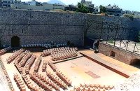
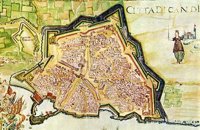 Iraklion at 27.3km (NE) The fortified enclosure of the Venetian Chandakas of the 15th century, which is still preserved today, is one of the most significant monuments of its kind in the whole Mediterranean basin. Triangular in shape, with its base at the sea, the mighty enceinte has a perimeter of about 5.5 kilometres. The hallmark of the defensive layout are the bastions, linked by curtain walls decorated at many points by escutcheons and the lion of St. Mark, symbol of Venetian omnipotence. The gates in the enceinte, which served to link the town to the countryside, still stand as important architectural monuments. To this day, the walls that withstood the Ottoman siege in the mid-17th century mark out the boundary of the old town. 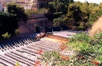 Iraklion at 27.3km (NE) Oasis is the part of the ditch of the new Venetian fortification that corresponds to the Rampant of Jesus. East of the entry of Oasis is the Cyprus square, roughly 600m from the centre of the city. For the first time, Oasis functioned as a small theatre during the 2nd world war when enough pines were cut. Then, up to 1963, a lot of assemblies took place here, mainly political. In 1963, the first serious effort of exploitation of Oasis as summer theatre, which was maintained up to 1976. In 1976 the theatre was created with the form that it has today. It became a modern open theatrical space of 1200 seats with all the necessary comforts.
 Iraklion at 27.4km (NE) Behind the "N.Kazantzakis open theatre", in the low square of the Gate of Jesus, was made after the proposal of Manos Hatzidakis and the design of Dionysis Fotopoulos, the Small Open Theatre, that recently named after the famous composer. It is constructed in a way so that is not caused damage in the Venetian Walls, that have been characterized as preservable monuments. In the "Manos Hatzidakis open theatre" (400 - 450 seats), as in "N.Kazantzakis open theatre" a lot of important events took place during the Heraklion Summer Festival. |

|
|
|
| ||
';top.fotoWin('/dbsf/pages_pics/15/1512321/giant_pithoi01.jpg');)
C
O
N
T
E
N
T
S
O
N
T
E
N
T
S